ML13095A196
| ML13095A196 | |
| Person / Time | |
|---|---|
| Site: | Turkey Point |
| Issue date: | 03/11/2013 |
| From: | Martinchich P Enercon Services |
| To: | Florida Power & Light Co, Office of Nuclear Reactor Regulation |
| References | |
| L-2013-087 FPL062-PR-001, Rev 0 | |
| Download: ML13095A196 (139) | |
Text
L-2013-087 Enclosure Turkey Point Units 3 and 4 Flood Hazard Reevaluation Report In Response to 50.54(f) Information Request Regarding Near-Term Task Force Recommendation 2.1
FLOODING HAZARDS REEVALUATION REPORT FPL062-PR-001, Rev. 0 IN RESPONSE TO THE 10 CFR 50.54(f) INFORMATION REQUEST REGARDING NEAR-TERM TASK FORCE RECOMMENDATION 2.1:
FLOODING for the Turkey Point Nuclear Generating Station Units 3 & 4 (PTN) 9760 SW 344th Street Florida City, FL 33035 Presented to:
Florida Power & Light Company 700 Universe Boulevard Juno Beach, FL 33408 Prepared by:
ENERCON Services, Inc.
4490 Old William Penn Highway Murrysville, Pennsylvania 15668 (724) 733-8711 March 2013 Printed Name/Title Affiliation Signature Date Preparer:
PAVL 5' [A ((L--
I"AQN 0-,_1_")1
- 0. C/lN-]_.
Reviewer:
.--f5 J P-R Ta31*- i" -
.CO&.
Approver:
r
].
e4;t
,2C *D f,
1-3 Site Sponsor:
e-erO *lm>.-r,
NTTF Recommendation 2.1 (Hazard Reevaluations): Flooding O
ENERCON Florida Power & Light Company - PTN March 2013 Excellence-Every project. Every day.
FPL062-PR-001, Rev. 0 Table of Contents Page 1.0 PURPO SE...........................................................................................................................................
I 1.1 Background......................................................................................................................................
1 1.2 Requested A ctions...........................................................................................................................
2 1.3 Requested Inform ation............................................................................................................
3 1.4 A pplicable G uidance D ocum ents................................................................................................
4 1.5 N otes on Term inology............................................................................................................
5 2.0 SITE IN FO RM A TIO N..............................................................................................................
6 2.1 D atum s and Projections..........................................................................................................
6 2.1.1 H orizontal D atum s and Projections...................................................................................
6 2.1.2 V ertical D atum s..............................................................................................................
6 2.1.3 V ertical D atum Relationships and Conversions................................................................
8 2.2 PTN Plant D escription............................................................................................................
8 2.3 Flood-Related and Flood Protection Changes to the Licensing Basis Since License Issuance....... 8 2.3.1 Current Licensing Basis.......................................................................................................
9 2.3.2 H urricane Readiness Procedure...........................................................................................
9 2.3.3 Flood Protection Features and Protected Equipm ent..........................................................
9 2.3.4 Flooding W alkdow n Sum m ary........................................................................................
11 2.4 Hydrosphere...................................................................................................................................
11 2.4.1 The Everglades......................................................................................................................
11 2.4.2 Everglades National Park-South Dade Conveyance System...........................................
12 2.4.3 B iscayne Bay.........................................................................................................................
13 3.0 Current License Basis for Flooding H azards...............................................................................
15 3.1 CLB - Local Intense Precipitation (LIP).................................................................................
15 3.2 CLB - Riverine (Rivers and Stream s) Flooding........................................................................
16 3.3 CLB - D am Breaches and Failure Flooding.............................................................................
16 3.4 CLB - Storm Surge................................................................................................
16 3.5 CLB - Seiche.................................................................................................................................
17 3.6 CLB - Tsunam i Flooding.........................................................................................................
17 3.7 CLB - Ice Induced Flooding.....................................................................................................
17 3.8 C LB - Channel M igration or D iversion....................................................................................
17 i
NTTF Recommendation 2.1 (Hazard Reevaluations): Flooding O
ENERCON Florida Power & Light Company - PTN March 2013 Excellence-Every project Every day.
FPL062-PR-001, Rev. 0 3.9 CLB - W ind-Generated W aves...............................................................................................
18 3.10 CLB -Hydrodynamic Loads....................................................................................................
18 3.11 CLB - W aterborne Projectiles and Debris Loads......................................................................
18 3.11.1 W ind-Generated M issile Hazard.......................................................................................
18 3.12 Debris and Sedimentation.........................................................................................................
19 3.13 CLB - Combined Events...........................................................................................................
19 3.14 CLB - Low-W ater Considerations..........................................................................................
19 4.0 FLOODING HAZARDS REEVALUATION.............................................................................
20 4.1 Local Intense Precipitation.......................................................................................................
21 4.1.1 LIP Intensity and Distribution...........................................................................................
22 4.1.2 Scenario A - LIP Occurring During Normal Plant Operations.........................................
22 4.1.3 Scenario B - LIP Occurring During Hurricane Preparedness Readiness Implementation..... 26 4.2 Flooding in Streams and Rivers................................................................................................
27 4.3 Dam Breaches and Failures.......................................................................................................
28 4.4 Storm Surge...................................................................................................................................
29 4.4.1 Overview - Numerical Surge M odel.................................................................................
29 4.4.2 Overview - Design Hurricane...........................................................................................
30 4.4.3 DELFT3D M odeling System.............................................................................................
30 4.4.4 Numerical Surge M odel Development.............................................................................
33 4.4.5 Physical Parameters...........................................................................................................
35 4.4.6 Numerical parameters......................................................................................................
36 4.4.7 Antecedent W ater Level.....................................................................................................
38 4.4.8 Parameter Calibration......................................................................................................
40 4.4.9 Probable M aximum Hurricane M odel...............................................................................
45 4.4.10 Storm Surge Computations...............................................................................................
53 4.4.11 Storm Surge Results.........................................................................................................
54 4.4.12 Coincident W ind-W ave Runup........................................................................................
55 4.4.13 Probable Maximum Storm Surge (PMSS) Maximum Water Level..................................
56 4.5 Seiche.............................................................................................................................................
56 4.6 Tsunam i..........................................................................................................................................
58 4.6.1 Antecedent W ater Level Estimate for PTN Units 6 & 7 SAR..........................................
59 4.6.2 10 Percent Exceedance High Tide for PTN Units 6 & 7 SAR..........................................
59 4.6.3 Sea Level Rise Estimate for PTN Units 6 & 7 SAR..........................................................
59 ii
NTTF Recommendation 2.1 (Hazard Reevaluations): Flooding q
ENERCON Florida Power & Light Company - PTN March 2013 Excellence-Every project Every day.
FPL062-PR-001, Rev. 0 4.6.4 A ntecedent W ater Level A djustm ent...............................................................................
60 4.6.5 Tsunam i A nalyses - O verview...........................................................................................
60 4.6.6 H istorical Tsunam i Record................................................................................................
60 4.6.7 Tsunam i A nalysis...................................................................................................................
61 4.6.8 Sum m ary of Tsunam i A nalyses Results..........................................................................
61 4.7 Ice-Induced Flooding.....................................................................................................................
63 4.8 Channel D iversion and M igration..............................................................................................
64 4.9 W ind-G enerated W aves...........................................................................................................
66 4.10 Hydrostatic and Hydrodynam ic Loads......................................................................................
67 4.11 W aterborne Projectiles and D ebris Loads..................................................................................
67 4.12 D ebris and Sedim entation.........................................................................................................
67 4.12.1 Summary of Debris and Sedimentation Mechanisms.......................................................
68 4.12.2 Sedim entation and D ebris Protection...............................................................................
69 4.13 Low W ater Considerations.......................................................................................................
70 4.14 Com bined Events Flooding.......................................................................................................
70 5.0 COMPARISON WITH CURRENT DESIGN BASIS.................................................................
71 5.1 Local Intense Precipitation (LIP)..............................................................................................
71 5.1.1 Local Intense Precipitation (LIP) Scenario A...................................................................
71 5.1.2 Local Intense Precipitation (LIP) Scenario B...................................................................
71 5.2 Riverine (Rivers and Stream s) Flooding....................................................................................
72 5.3 D am Breaches and Failure Flooding.........................................................................................
72 5.4 Storm Surge...................................................................................................................................
72 5.5 Seiche.............................................................................................................................................
72 5.6 Tsunam i Flooding..........................................................................................................................
72 5.7 Ice Induced Flooding.....................................................................................................................
73 5.8 Channel M igration or D iversion...............................................................................................
73 5.9 W ind-G enerated W aves...........................................................................................................
73 5.10 H ydrodynam ic Loads.....................................................................................................................
73 5.11 W aterborne Projectiles and D ebris Loads..................................................................................
73 5.12 D ebris and Sedim entation.........................................................................................................
74 5.13 Low -W ater Considerations.......................................................................................................
74 5.14 Com bined Events...........................................................................................................................
74 6.0 IN TERIM EV A LU A TION A ND A CTION S...............................................................................
75 iii
NTTF Recommendation 2.1 (Hazard Reevaluations): Flooding O
ENERCON Florida Power & Light Company - PTN March 2013 Excellence-Every project. Every day.
FPL062-PR-00 1, Rev. 0 6.1 Local Intense Precipitation.......................................................................................................
75 6.2 Riverine (Rivers and Stream s) Flooding..................................................................................
75 6.3 D am Breaches and Failure Flooding.........................................................................................
75 6.4 Storm Surge...................................................................................................................................
75 6.5 Seiche.............................................................................................................................................
76 6.6 Tsunam i..........................................................................................................................................
76 6.7 Ice Induced Flooding.....................................................................................................................
76 6.8 Channel D iversion & M igration...............................................................................................
76 6.9 W ind-G enerated W aves...........................................................................................................
76 6.10 H ydrostatic and Hydrodynam ic Loads......................................................................................
77 6.11 W aterborne Projectiles and D ebris Loads..................................................................................
77 6.12 D ebris and Sedim entation.........................................................................................................
77 6.13 Low W ater Considerations.......................................................................................................
77 6.14 Com bined Events Flooding.......................................................................................................
77 7.0 A D D ITIO N A L A CTIO N S...........................................................................................................
78 8.0 REFEREN C ES.................................................................................................................................
79 iv
NTTF Recommendation 2.1 (Hazard Reevaluations): Flooding
) E N E RC O N Florida Power & Light Company - PTN March 2013 Excellence-Every project. Every day.
FPL062-PR-001, Rev. 0 List of Tables Table 2-1.
Site Tidal Datum Conversions Table 2-2.
East Miami-Dade County Drainage Subbasin Areas and Outfall Structures Table 2-3.
NOAA Tide Gages Near PTN and Corresponding Tidal Range Table 3-1.
PTN Tornado Generated Missiles Table 3-2.
SRP Defined Missiles Table 4-1.
1-Minute Precipitation Depths, 1-Hour LIP Center Temporal Distribution Table 4-2.
Table of Results for Flow Depth, Peak Water Surface Elevation (WSEL), and Maximum Flow Velocity (Scenario A)
Table 4-3.
Summary of Results for the Analysis of the Flood Protected Areas (Scenario B)
Table 4-4.
Topographic and Bathymetric Characteristics of Datasets Used as Input for Hurricane Modeling Table 4-5.
Vertical Unit and Datum Conversions for Datasets within the Site Grid Table 4-6.
Station Results for 10% Exceedance High and Low Tide Table 4-7.
Tide Station Trend Model Results Table 4-8.
Calibrated Tidal Station Constituents Table 4-9.
Hurricane Andrew Storm Attributes Table 4-10.
Hurricane Donna Storm Attributes Table 4-11.
Domain Geometry Summary of Parameters for Delft3D Grids Table 4-12.
Range of Storm Parameters for PMSS Table 4-13.
The Saffir-Simpson Hurricane Scale Table 4-14.
Category 4 & 5 Hurricanes within 100 Nautical Miles of PTN Table 4-15.
Central Pressure (Po) and Radius of Maximum Winds (R) for Extreme Hurricanes Table 4-16.
Summary of Historical Tsunami Runup Events in the Eastern of U.S.
Table 4-17.
USGS Stations Used to Characterize the Typical Water Temperatures Near PTN Table 4-18.
Subfreezing and Corresponding Daily Average Temperatures at NCDC Stations Near PTN v
O ENERCON Excellence-Every project. Every day.
NTTF Recommendation 2.1 (Hazard Reevaluations): Flooding Florida Power & Light Company - PTN March 2013 FPL062-PR-001, Rev. 0 List of Figures Figure 2-1.
Figure 2-2.
Figure 2-3.
Figure 2-4.
Figure 2-5.
Figure 2-6.
Figure 2-7.
Figure 2-8.
Figure 3-1.
Figure 3-2.
Figure 4-1.
Figure 4-2.
Figure 4-3.
Figure 4-4.
Figure 4-5.
Figure 4-6.
Figure 4-7.
Figure 4-8.
Figure 4-9.
Figure 4-10.
Figure 4-11.
Figure 4-12.
Figure 4-13.
Figure 4-14.
Figure 4-15.
Figure 4-16.
Figure 4-17.
Figure 4-18.
Figure 4-19.
Figure 4-20.
Figure 4-21.
Figure 4-22.
Figure 4-23.
Figure 4-24.
Figure 4-25.
Figure 4-26.
Figure 4-27.
Figure 4-28.
PTN Site Location Schematic Illustrating Relationships Between Fixed and Tidal Datums PTN Site Survey Map of South Florida Watershed Subregions Surface Water Conveyance System in the South Florida Region in (A) 1970 and (B) 1990 Location of Eastern Miami-Dade County Surface Water Management Basins Locations of ENP-SDCS Canals, Flow Control Structures on Canal Outlets, and Biscayne Bay Planning Regions Locations of NOAA Tide and USGS Streamflow Gages Near PTN Network of Barriers for Main Plant External Flood Protection (Drawing Number 5610-C-1695)
Missiles Generated by Wind Simulated for Tormis Code HMR52 - I-Hour 1-Square Mile PMP 60 Minute Local Intense Precipitation (LIP) Curve Local Intense Precipitation (LIP) Distribution Elevations Rendered on the Study Area Grid Manning's n Value Maximum Flow Depth (ft)
Points of Interest Overlaid with the Maximum Flow Depth (ft)
Points of Interest Overlaid with Main Plant Site Drawing Points of Interest Overlaid with the Peak Flow Velocity (fr/s)
Approximate Flood Protection Areas DELFT3D Grid Model Domain Sea Level Rise - Linear Trend Sea Level Rise - 2nd Order Trend Tidal Stations Used for Storm Surge Model Calibration Tidal Stations Calibration Results at IHO Station Miami Harbor Entrance, Florida Storm Tracks for Calibration/Validation Observed Storm Surge Water Levels for Hurricane Andrew DELFT3D Computed Hurricane Andrew Storm Surge at Time Step 1 in the Fine Grid 2 Model Domain DELFT3D Computed Hurricane Andrew Storm Surge at Time Step 2 in the Fine Grid 2 Model Domain DELFT3D Computed Hurricane Andrew Storm Surge at Time Step 3 in the Fine Grid 2 Model Domain DELFT3D Computed Hurricane Donna Storm Surge at Time Step I in the Fine Grid 2 Model Domain Observed Storm Surge Water Levels for Hurricane Donna Coastal Distance Intervals in Nautical Miles and Kilometers Central Pressure for the Probable Maximum Hurricane (PMH)
Adopted Upper and Lower Limits of Radius of Maximum Winds for the Probable Maximum Hurricane (PMH)
Adopted Probable Maximum Hurricane (PMH) Upper and Lower Limits of Forward Speed Maximum Allowable Range for the Probable Maximum Hurricane Track Direction Tracks of Historical Hurricane (Intensities of Category 4 & 5) in the Region of PTN vi
O ENERCON Excellence-Every project Every day.
NTTF Recommendation 2.1 (Hazard Reevaluations): Flooding Florida Power & Light Company - PTN March 2013 FPL062-PR-00 1, Rev. 0 Figure 4-29.
Figure 4-30.
Figure 4-31.
Figure 4-32.
Figure 4-33.
Figure 4-34 Figure 4-35 Figure 4-36 Figure 4-37 Figure 4-38.
Figure 4-39.
Figure 4-40.
Figure 4-4 1.
Figure 4-42.
Figure 4-43.
Figure 4-44.
Figure 4-45.
Figure 4-46.
Figure 4-47.
Figure 4-48 Synthetic Storm Tracks Plot Central Pressure (P0) Versus Radius of Maximum Winds (R) for Extreme Hurricanes Plot Central Pressure (Po) Versus Radius of Maximum Winds (R) for Extreme Hurricanes, Revised 2013 Hurricane Pressure Field Wind Field and Wind Speed Plots Barrier Island Breakwater Relationship of Breakwater to Power Block Maximum Wave Height Over the Breakwater Structure Representative Cross Section for Wave Analysis Location Map Showing the Extent of the AGMTHAG Study Area and Geologic Features that May Influence Landslide Distribution along the U.S. Atlantic Margin Distribution of Different Landslide Types along the U.S. Atlantic Margin Location Map Showing the Size, Distribution, and Composition of Landslides in the Gulf of Mexico Plate Tectonic Setting and Bathymetry of the Eastern Azores-Gibraltar Region The Caribbean Plate Boundary and its Tectonic Elements Simulated Tsunami Marigram Near PTN (with Manning's n of 0.02 and non-reflective boundaries)
Tsunami Water Level Contours Near PTN 4.5 Hours in the Model Simulation Corresponding to the Time Close to the Maximum Water Level at the Site Meteorological and USGS Stations Near PTN Water Temperatures at the USGS Stations Near PTN Historic Shoreline Changes at PTN Hydrostatic and Hydrodynamic Pressure vii
NTTF Recommendation 2.1 (Hazard Reevaluations): Flooding
) EN ERC O N Florida Power & Light Company - PTN March 2013 Excellence-Every project. Every day.
FPL062-PR-001, Rev. 0 1.0 PURPOSE This report provides the Florida Power and Light (FPL) response to the U.S. Nuclear Regulatory Commission's (NRC) March 12, 2012 request for information pursuant to the post-Fukushima Near-Term Task Force (NTTF) Recommendation 2.1 flooding hazards reevaluation of Turkey Point Nuclear Generating Station (also known as Plant Turkey Nuclear, or PTN).
1.1 Backaround In response to the Fukushima Dai-ichi nuclear facility accident resulting from the March 11, 2011 earthquake and subsequent tsunami, the NRC established the NTTF to conduct a systematic review of NRC processes and regulations, and to make recommendations to the NRC for its policy direction. The NTTF reported a set of recommendations that were intended to clarify and strengthen the regulatory framework for protection against natural phenomena.
On March 12, 2012, the NRC issued an information request pursuant to Title 10 Code of Federal Regulations (CFR) 50.54(f) (NRC, 2012a) which included six enclosures:
- 1. NTTF Recommendation 2.1: Seismic
- 2. NTTF Recommendation 2.1: Flooding
- 3. NTTF Recommendation 2.3: Seismic
- 4. NTTF Recommendation 2.3: Flooding
- 5. NTTF Recommendation 9.3: Emergency Preparedness
- 6. Staffing
- 7. Licensees and Holders of Construction Permits In accordance with Enclosure 2 of the NRC 10 CFR 50.54(f) letter request (NRC, 2012a), licensees are required to reevaluate the flooding hazards at their sites against present-day regulatory guidance and methodologies being used for early site permits (ESP) and combined license applications (COLA).
I
NTTF Recommendation 2.1 (Hazard Reevaluations): Flooding SE N E RC O N Florida Power & Light Company - PTN March 2013 Excellence-Every project. Every day.
FPL062-PR-001, Rev. 0 1.2 Requested Actions Per Enclosure 2 of the NRC 10 CFR 50.54(f) letter request (NRC, 2012a),
Addressees are requested to perform a reevaluation of all appropriate external flooding sources, including the effects from local intense precipitation on the site, probable maximum flood (PMF) on stream and rivers, storm surges, seiches, tsunami, and dam failures. It is requested that the reevaluation apply present-day regulatory guidance and methodologies being used for ESP and COL reviews including current techniques, software, and methods used in present-day standard engineering practice to develop the flood hazard. The requested information will be gathered in Phase 1 of the NRC staff's two phase process to implement Recommendation 2.1, and will be used to identify potential vulnerabilities.
For the sites where the reevaluated flood exceeds the design basis, addressees are requested to submit an interim action plan that documents actions planned or taken to address the reevaluated hazard with the hazard evaluation.
Subsequently, addressees should perform an integrated assessment of the plant to identify vulnerabilities and actions to address them.
The scope of the integrated assessment report will include full power operations and other plant configurations that could be susceptible due to the status of the flood protection features. The scope also includes those features of the ultimate heat sinks (UHS) that could be adversely affected by the flood conditions and lead to degradation of the flood protection (the loss of UHS from non-flood associated causes are not included). It is also requested that the integrated assessment address the entire duration of the flood conditions.
FPL submitted a 90-day response letter (Letter L-2012-237) to the U.S. NRC, titled "Response to NRC Request for Information Pursuant to 10 CFR 50.54(f) Regarding the Flooding Aspects of Recommendations 2.1 and 2.3 of the Near-Term Task Force Review of Insights from the Fukushima Dai-ichi Accident," dated June 11, 2012 (FPL,2012b). In the letter, FPL committed to providing the information requested in the RFI.
2
NTTF Recommendation 2.1 (Hazard Reevaluations): Flooding O
EN ERC O N Florida Power & Light Company - PTN March 2013 Excellence-Every project. Every day.
FPL062-PR-00 1, Rev. 0 1.3 Requested Information This report provides the following requested information for PTN, in accordance with Enclosure 2 of the NRC 10 CFR 50.54(f) letter request (NRC, 2012a):
- a. Site information related to the flood hazard. Relevant structure, systems and components (SSCs) important to safety and the UHS are included in the scope of this reevaluation, and pertinent data concerning these SSCs should be included. Other relevant site data includes the following:
Detailed site information (both designed and as-built), including present-day site layout, elevation of pertinent SSCs important to safety, site topography, as well as pertinent spatial and temporal data sets (Section 2.0);
ii.
Current design basis flood elevations for all flood causing mechanisms (Section 2.3);
iii.
Flood-related changes to the licensing basis and any flood protection changes (including mitigation) since license issuance (Section 2.3.3);
iv.
Changes to the watershed and local area since license issuance (Section 2.4);
- v.
Current licensing basis flood elevations for all flood causing mechanisms (Section 3.0);
vi.
Additional site details, as necessary, to assess the flood hazard (i.e., bathymetry, walkdown results, etc.)
- b.
Provide evaluations of the flood hazard for each flood causing mechanism, based on present-day methodologies and regulatory guidance. Analyses are provided for each flood causing mechanism that may impact the site including local intense precipitation and site drainage, flooding in streams and rivers, dam breaches and failures, storm surge and seiche, tsunami, channel migration or diversion, and combined effects. Mechanisms that are not applicable at the site may be screened-out; however, a justification should be provided. Provide a basis for inputs and assumptions, methodologies and models used including input and output files, and other pertinent data (Section 4.0).
- c.
Comparison of current and reevaluated flood causing mechanisms at the site. Provide an assessment of the current design basis flood elevation to the reevaluated flood elevation for each flood causing 3
NTTF Recommendation 2.1 (Hazard Reevaluations): Flooding EN ERC O N Florida Power & Light Company - PTN March 2013 Excellence-Every project. Every day.
FPL062-PR-001, Rev. 0 mechanism. Include how the findings from Enclosure 2 of the 10 CFR 50.54(f) letter (i.e.,
Recommendation 2.1 flood hazards reevaluation) support this determination. If the current design basis flood bounds the reevaluated hazard for all flood causing mechanisms, include how this finding was determined (Section 5.0).
- d.
Interim evaluation and actions taken or planned to address any higher flooding hazards relative to the design basis, prior to completion of the integrated assessment described below, if necessary (Section 6.0).
- e.
Additional actions beyond Requested Information Item 1.d taken or planned to address flooding hazards, if any (Section 7.0).
1.4 Applicable Guidance Documents The following documents were used as guidance in performing the flooding hazards reevaluation analyses:
ANSI/ANS, 1992, American Nuclear Society (ANSI/ANS), "Determining Design Basis Flooding at Power Reactor Sites ANS 2.8-1992," La Grange Park, Illinois, 1992.
NRC, 1977, United States Nuclear Regulatory Commission (NRC), "Design Basis Floods for Nuclear Power Plants," Regulatory Guide 1.59, Revision 2 Washington, D.C., 1977.
NRC, 1978, United States Nuclear Regulatory Commission (NRC), "Standard Format and Content of Safety Analysis Reports for Nuclear Power Plants," Regulatory Guide 1.70, Revision 3, Washington, D.C., 1978.
NRC, 2007, United States Nuclear Regulatory Commission (NRC), "Standard Review Plan for the Review of Safety Analysis Reports for Nuclear Power Plants: LWR Edition," NUREG-0800, Washington, D.C.,
March, 2007.
NRC, 2009, United States Nuclear Regulatory Commission (NRC), "Tsunami Hazard Assessment at Nuclear Power Plant Sites in the United States of America - Final Report," NUREG/CR-6966, PNNL-17397, Richland, WA, March 2009.
NRC, 2011, United States Nuclear Regulatory Commission (NRC), "Design-Basis Flood Estimation for Site Characterization at Nuclear Power Plants in the United States of America," NUREG/CR-7046, Washington, D.C., November, 2011.
NRC, 2013, United States Nuclear Regulatory Commission (NRC), "Guidance for Performing a Tsunami, Surge and Seiche Flooding Safety Analysis Revision 0," Japan Lessons-Learned Project Directorate Interim Staff Guidance, JLD-ISG-2012-06, January 4, 2013.
4
O ENERCON Excellence-Every project. Every day.
NTTF Recommendation 2.1 (Hazard Reevaluations): Flooding Florida Power & Light Company - PTN March 2013 FPL062-PR-001, Rev. 0 1.5 Notes on Terminology JLD-ISG-2012-06 suggests that the term "probable maximum" should be replaced with "design basis" for flood-causing mechanisms (e.g., "probable maximum storm surge" would be replaced with "design basis storm surge"). However, to avoid confusion with the current design basis, "probable maximum" terminology will be used to describe the reevaluated flood-causing mechanisms, as the new analyses are not adopted as the plant's "design basis." Also, in discussing storm surge, the terms "storm" and "hurricane" may be used interchangeably.
5
NTTF Recommendation 2.1 (Hazard Reevaluations): Flooding EN ERC O N Florida Power & Light Company - PTN March 2013 Excellence-Every project Every day.
FPL062-PR-001, Rev. 0 2.0 SITE INFORMATION The PTN site is located on the western shore of Biscayne Bay approximately 25 miles south of Miami, 8 miles east of Florida City, and 9 miles southeast of Homestead, Florida. Miami-Dade County is bounded on the north by Broward County, on the west by Monroe and Collier Counties, on the east by Biscayne Bay and the Atlantic Ocean, and on the south by the Florida Bay and the Florida Keys (Monroe County). Miami-Dade County is located along the southeast tip of the Florida Peninsula and covers approximately 2,000 square miles of land area with approximately one-third of the area consisting primarily of the Everglades National Park. The site location map is presented as Figure 2-1.
2.1 Datums and Projections Various horizontal and vertical datums and mapping projections are referenced throughout this Report. This section describes the horizontal and vertical datums and mapping projections used, their definitions and relationships, and the methods used to convert from one datum or projection to another.
2.1.1 Horizontal Datums and Progections A horizontal datum is a system which defines an idealized surface of the earth for positional referencing.
The North American Datum of 1983 (NAD83) is the official horizontal datum for United States surveying and mapping activities. Latitude and longitude are typically used to identify location in spherical units.
A map projection is a mathematical transformation that converts a three-dimensional (spherical) surface onto a flat, planar surface. Different projections cause difference types of distortions, and depending on their intended use, projections are chosen to preserve different relationship of characteristics between features.
Projections in the United States are typically defined as State Plane coordinate systems with units of Northing and Easting. The extent of State Plane coordinate systems are limited by the acceptable distortion.
The United States is divided into many State Plane maps; large states can be defined by several maps. The PTN site survey uses the NAD83 horizontal datum and project onto the State Plane Florida East coordinate system.
2.1.2 Vertical Datums There are two types of vertical datums: tidal and fixed. Fixed datums are reference level surfaces that have a constant elevation over a large geographical area. Tidal datums are standard elevations that are used as 6
NTTF Recommendation 2.1 (Hazard Reevaluations): Flooding O
E N E R C O N Florida Power & Light Company - PTN March 2013 Excellence-Every project Every day.
FPL062-PR-00 1, Rev. 0 references to measure local water levels. The following is a list of tidal and fixed datums, as defined by NOAA (NOAA, 201 lc):
" Mean Higher High Water (MHHW) - the average of the higher high water height.
Mean High Water (MHW) - the average all high water heights.
Mean Sea Level (MSL) - the arithmetic mean of hourly heights.
Mean Low Water (MLW) - the average of all the low water heights.
Mean Low Water (Site Datum) (MLW-Site) - a site datum that is referenced on plant drawings and license documents, tied to Site Benchmarks determined to be 2.307 feet below NAVD88 datum during recent site survey (Ford, 2012a).
" Mean Lower Low Water (MLLW) - the average of the lower low water height.
North American Vertical Datum of 1988 (NAVD88) - fixed vertical control datum, referenced to the tide station and benchmark at Pointe-au-Pere, Rimouski, Quebec, Canada.
" National Geodetic Vertical Datum of 1929 (NGVD29) - fixed vertical control datum, affixed to 21 tide stations in the United States and 5 in Canada.
The CLB and historical PTN survey drawings are typically referenced to "Mean Low Water" vertical datum, to which site benchmarks are referred. However, during a recent survey (Ford, 2012b), it was discovered that this datum does not coincide with a local tide station mean low water; thus, this site datum is referred to as "MLW-Site." This has been entered in the corrective action program. The level of protection exceeds the possible difference with margin, and this is not an immediate concern.
The updated site survey and reevaluation are in NAVD88 datum, therefore this issue has no impact on the results presented in this report.
The NRC has expressed a preference for flood level reporting in NAVD88. The most recent PTN site survey datum is referenced to NAVD88. Other datums are referenced or used where appropriate. For example, the storm surge modeling is performed in the MSL datum, as the model domain is the Atlantic Ocean where a fixed topographic datum (i.e., NAVD88) would be inappropriate. For convenience of applicability, when other datums are referenced, the equivalent elevation in NAVD88 will also be provided.
7
NTTF Recommendation 2.1 (Hazard Reevaluations): Flooding q
EN ERC O N Florida Power & Light Company - PTN March 2013 Excellence-Every project. Every day.
FPL062-PR-001, Rev. 0 2.1.3 Vertical Datum Relationships and Conversions Where required, vertical transformations were performed using NOAA's vertical transformation tool, VDatum (NOAA, 2011 a). VDatum converts data from different vertical references into a common reference coordinate system, both horizontally and vertically.
For reference in this report, the relative relationships of the various vertical datums are provided in Figure 2-2. Also, vertical datum conversion relationships and equations are provided in Table 2-1. Note that these conversions only apply in the vicinity of PTN, and conversions would vary at other locations.
2.2 PTN Plant Description The PTN Site is part of the larger Turkey Point plant property located in unincorporated Miami-Dade County, Florida. The approximate 9000-acreTurkey Point plant property includes two gas/oil-fired steam electric generating units (Units 1 & 2), one natural gas combined cycle plant (Unit 5), and two nuclear powered steam electric generating units (Units 3 & 4), and an extensive 6700-acre cooling water canal system. FPL has also submitted a Combined Operating License Application (COLA) Safety Analysis Report (SAR) for the proposed construction of two more nuclear reactors (Units 6 & 7). The SAR included flooding analyses for the proposed Units 6 & 7 reactors (NEE, 2012). The Turkey Point plant property facility layout is presented as Figure 2-1.
Topographic relief at the site is low and relatively flat. The plant floor is at Elevation +15.7 feet-NAVD88 at the power block, which includes the Turbine Building, Auxiliary Building, and Control Building. The plant area is significantly higher than the surrounding topography as shown on Figure 2-1.
The site survey completed on October 26, 2012 is shown on Figure 2-3.
2.3 Flood-Related and Flood Protection Changes to the Licensing Basis Since License Issuance Since the issuance of the license, several protective features and procedures have been implemented at PTN.
These include:
Seals have been installed around piping that penetrates the flooding barriers Procedures are in place to install temporary pumps to dewater closed in areas for a severe hurricane Procedures are in place to plug drains and prevent backflow from exterior catch basins
" Procedures are in place to fortify and seal stoplogs (moveable barriers) with sandbags 8
NTTF Recommendation 2.1 (Hazard Reevaluations): Flooding O
EN ERC O N Florida Power & Light Company - PTN March 2013 Excellence-Every project Every day.
FPL062-PR-001, Rev. 0 2.3.1 Current LicensinE Basis The probable maximum hurricane (PMH) is the design basis external flood condition considered for PTN.
The CLB maximum flood stage resulting from the maximum probable hurricane is elevation +16 feet-NAVD88 (+18.3 feet-MLW-Site Datum in licensing documents) (FPL, 1999). Stillwater physical protection is provided to an elevation of 17.7 feet-NAVD88 and wave protection is provided to an elevation of 19.7 feet-NAVD88 on the east side of the plant.
2.3.2 Hurricane Readiness Procedure During hurricane season (June through November), the hurricane season readiness procedure is implemented 72 hours8.333333e-4 days <br />0.02 hours <br />1.190476e-4 weeks <br />2.7396e-5 months <br /> prior to the projected arrival of tropical storm force winds (39 mph). Actions taken by plant staff for flood protection include:
Installation of portable dewatering pumps, electric generators with fuel supplies, and associated suction and discharge hoses in various plant areas.
Installation of mechanical and inflatable plugs in plant drainage system drains.
Installation of stoplogs at door openings on plant flood protection walls.
Filling sandbags and building sandbag dikes at specified plant doors, drains, and manhole covers.
During the flooding protection features walkdown effort performed as part of the request for information pursuant to the post-Fukushima Near-Term Task Force (NTTF) Recommendation 2.3, the ability to perform the above actions, well within the available warning time, was demonstrated.
2.3.3 Flood Protection Features and Protected Eguipment For most flooding hazards, equipment is protected by the elevation of the plant relative to the surrounding topography. In addition equipment is located on raised curbs and much of the critical equipment is located in the upper floors of the structures. Penetrations through flood barriers are sealed to prevent floodwaters from penetrating through the barriers. This includes piping seals, conduit seals, and sealing of manholes.
For severe hurricanes, the Hurricane Season Readiness Procedures provide for a continuous flood protection perimeter around equipment vital to safety that is located on the lower levels. Grade level of the plant structures at PTN is +15.7 feet-NAVD88 (+18 feet-MLW-Site).
Through the implementation of the hurricane readiness procedure, external flood protection is provided to +17.7 feet-NAVD88 (+20 feet-MLW-Site) to the north, south, and west of the facility by a continuous barrier consisting of exterior building walls, flood walls, a flood embankment, and stoplogs at the door openings. External flood protection is 9
NTTF Recommendation 2.1 (Hazard Reevaluations): Flooding EN ERC O N Florida Power & Light Company - PTN March 2013 Excellence-Every project Every day.
FPL062-PR-001, Rev. 0 provided to +19.7 feet-NAVD88 (+22 feet-MLW-Site) to the east of the facility with flood protection stoplogs in place. The protection to the east is provided to protect against the maximum wave runup (FPL, 1999).
Also, during potential storm surge-related flooding events (i.e., tropical storms and hurricanes), drain plugs are installed to prevent flooding within the flood-protected areas due to backflow from the storm surge through the drainage system.
Temporary dewatering pumps are installed to remove any rainwater accumulation in these areas while the drains are plugged.
In summary, hurricane preparation actions taken that are credited for flood protection include: installation of portable dewatering pumps, drain plugs, stoplogs, and small sandbag dikes. The Auxiliary Building, which houses the Emergency Core Cooling, Containment Spray, Charging, Component Cooling Water, Boric Acid Injection systems and their corresponding support systems is protected to still water levels of up to +17.7 feet-NAVD88 and wave runup up to +19.7 feet-NAVD88.
The Control Building houses the DC Power equipment located at 27.8 feet and 39.7 feet-NAVD88, the Control Room located at 39.7 feet-NAVD88, and the Control Rod system located at 27.8 feet-NAVD88. All of this equipment is located well above the flood level.
The Turbine Building Area, which houses the Auxiliary Feedwater system4160 V switchgear, and 480 V Motor Control Centers, is protected by the Auxiliary, Control and Containment Buildings to the East and by flood walls and stop logs up to +17.7 feet-NAVD88 to the north, south and west. The 480 V load centers are located at elevation 28.7 ft-NAVD88, well above the flood level.
The Unit 3 Emergency Diesel Generators are located in a structure that is protected to 19.7 feet-NANVD88 to the east and by flood walls and stoplogs on the west to 17.7 feet-NAVD88. The Unit 4 Emergency Diesel Generators are located in a newer structure protected to a minimum of 20.7 feet-NAVD88.
The spent fuel cooling equipment is housed in the Spent Fuel Pool Building and protected to 19.7 feet-NAVD88.
The intake cooling water (ICW) pump motor bases are located at +20.2 feet-NAVD88 (+22.5 feet-MLW-Site), and are therefore protected by their elevation (FPL, 1999).
10
NTTF Recommendation 2.1 (Hazard Reevaluations): Flooding O
EN ERC O N Florida Power & Light Company - PTN March 2013 Excellence-Every project Every day.
FPL062-PR-00 1, Rev. 0 2.3.4 Floodin! Walkdown Summary FPL has submitted a Flooding Walkdown report in response to the 50.54(f) information request regarding NTTF recommendation 2.3: Flooding for PTN (FPL, 2012a). The walkdowns were performed in accordance with NEI 12-07 (Rev. 0-A), "Guidelines for Performing Verification of Plant Flood Protection Features,"
dated May, 2012 (NEI, 2012c). This document was endorsed by the NRC on May 31, 2012. No operability issues were identified. Minor deficiencies were identified and entered in the corrective action program.
There are no planned flood protection enhancements or flood mitigation measures at PTN resulting from the flood protection walkdowns.
2.4 Hydrosphere PTN is located adjacent to Biscayne Bay within the Everglades drainage basin of the South Florida Watershed - Everglades Subregion, as shown on Figure 2-4. The physical geographic features in the subregion that govern surface water flows southward from Lake Okeechobee include the Immokalee Rise, Big Cypress Spur, Atlantic Coastal Ridge, and the Everglades physiographic sub-provinces. Flood control structures and an elaborate drainage canal system constructed in the past century have since modified the natural drainage pattern, its freshwater discharge, and its interaction with the coastal bays in the Atlantic Ocean and Gulf of Mexico (McPherson and Halley, 1997; Wolfert et al., 2007; and Godfrey and Catton, 2006). Changes in the surface water conveyance systems since the construction of PTN (1970 versus 1990) are depicted on Figure 2-5. Additional descriptions of the Everglades and the development and usage of the drainage canal systems are described below.
2.4.1 The Everglades The Everglades is the largest wetland in the continental United States and was part of the larger, natural Kissimmee-Okeechobee-Everglades watershed that once extended south from Lake Okeechobee to the southernmost extremity of peninsular Florida. Elevations within the Everglades, which were formed on limestone bedrock, are lower than the elevations in the Flatwoods or Atlantic Coastal Ridge physiographic provinces and slope toward the south with an average gradient less than 2 inches per mile (Godfrey and Catton, 2006; Galloway et al., 1999). The park is approximately 15 miles west of the plant property and is adjacent to the southeast Florida drainage canal system.
11
NTTF Recommendation 2.1 (Hazard Reevaluations): Flooding C EN ERC O N Florida Power & Light Company - PTN March 2013 Excellence-Every project. Every day.
FPL062-PR-001, Rev. 0 The Atlantic Coastal ridge that separates the Everglades from the Atlantic coastline has a maximum elevation of approximately 20 feet above MSL datum (Galloway et al., 1999), which is equivalent to the National Geodetic Vertical Datum of 1929 (NGVD 29). Applying the datum conversion, the maximum elevation of the Atlantic Coastal Ridge is approximately 18.4 feet-NAVD88. Historically, nearly all of southeast Florida, except for the Atlantic Coastal ridge, was flooded annually (Galloway et al., 1999).
Land reclamation for agriculture, construction of flood control levees and drainage canals, and urbanization irreversibly modified the hydrology of the region. Before flood control, agriculture, and urbanization development, which began in the late nineteenth century, the natural water level in Lake Okeechobee overflowed its southern bank at elevations 20 to 21 feet NGVD 29 (18.4 to 19.4 feet-NAVD88). Currently, the lake water level is maintained at approximately 13 to 16 feet NGVD 29 (11.4 to 14.4 feet-NAVD88)
(Galloway et al., 1999). Surface water flows are maintained by pumping.
In 2000, the Federal Water Resources Development Act authorized a Comprehensive Everglades Restoration Plan (CERP) to provide a framework and guide the restoration, protection, and preservation of the water resources of central and southern Florida, including the Everglades (CERP, 2012). The CERP projects intend to restore water flows that have changed over the past century, and plan on capturing and storing freshwater flows in surface and subsurface reservoirs, which are currently released to the Atlantic Ocean and Gulf of Mexico. The freshwater would be directed to the wetlands, lakes, rivers, and estuaries of southern Florida while also ensuring future urban and agricultural water supplies (CERP, 2012). The surface and subsurface reservoirs would mainly be located within the low-lying areas. Failure of these reservoirs would not adversely affect the functioning of the safety-related structures and components at PTN based on distance to the plant and the relative elevation of these low-lying water bodies to the higher plant grade elevation.
2.4.2 Everglades National Park-South Dade Conveyance System The Everglades National Park-South Dade conveyance system provides agricultural water supply, control flooding, and mitigating saltwater intrusion (Renken et al., 2005). The existing north-south directed borrow canals L-30 and L-31N/L-31W convey water from the Miami Canal (C-6) to the Everglades. The west-east running canals provide drainage from the southern Dade development corridor to the Biscayne Bay by control structures at the mouth of the canals (Renken et al., 2005). The western borrow canal of the L-31E Levee (L-31E Canal) runs parallel to the coastline of Biscayne Bay in southern Miami-Dade County, separating the coastal wetlands along the bay from the mainland. Starting north of Black Creek Canal (C-1) and extending to Card Sound Road in the south, the L-31E Levee has a crest elevation of approximately 12
NTTF Recommendation 2.1 (Hazard Reevaluations): Flooding O
EN ERC O N Florida Power & Light Company - PTN March 2013 Excellence-Every project Every day.
FPL062-PR-001, Rev. 0 7 feet-NAVD88. The levee and canal are located immediately west of the Turkey Point cooling canals (SFWMD, 2006).
Based on hydrology of the area, the U.S. Army Corps of Engineers (USACE) delineated water management subbasins in southern Miami-Dade County (Cooper and Lane, 1987). The water management area includes 17 subbasins that contribute flow to Biscayne Bay and the Everglades, as shown on Figure 2-6. Surface water that flows from the drainage subbasins to Biscayne Bay or the Everglades is controlled by numerous flow control structures. Flow control structures also regulate flow between the subbasin areas. The subbasins' names are based on the major canal in the subbasin. A summary of the subbasins (with names corresponding to the primary canal servicing each of the areas), drainage areas, and the control structures at basin outlets that regulate flow to Biscayne Bay is provided in Table 2-2. The locations of the control structures are shown on Figure 2-7. As noted previously, these control structures are located a relatively far distance from PTN, and are situated at lower elevations relative to the PTN plant grade elevation.
2.4.3 Biscayne Bay Biscayne Bay is a shallow coastal lagoon located on the lower southeast coast of Florida (Langevin, 2001).
The bay is approximately 38 miles long, approximately 11.2 miles wide on average, and has an area of approximately 428 square miles (USGS, 2004 and Wingard et al. 2004). The bay began forming between 5000 and 3000 years ago as sea level rose and filled a limestone depression (Wolfert et al., 2007). The eastern boundary of Biscayne Bay is composed of barrier islands that form a part of the Florida Keys and separates the bay from the Atlantic Ocean (Cantillo et al., 2000). Several canals on the western shore discharge surface water into the bay. Biscayne Bay is connected to the Atlantic Ocean by a wide and shallow opening of coral shoal near the middle of the bay that is known as the Safety Valve, and by several channels and cuts (Cantillo et al., 2000). The principal circulation forces in Biscayne Bay are tidal, although winds that persist for longer than a complete tidal cycle of 12 to 13 hours1.50463e-4 days <br />0.00361 hours <br />2.149471e-5 weeks <br />4.9465e-6 months <br /> cause relatively large water movements.
Because Biscayne Bay is not a drowned river valley, unlike most estuaries, sediment inflow to the bay from rivers/canals is insignificant. Near the plant property, part of Biscayne Bay is within the designated boundaries of the Biscayne National Park that contains a narrow fringe of mangrove forests along the mainland. Similar mangrove zones are present along the southern expanse of Biscayne Bay, and in the northernmost islands of the Florida Keys including Elliott Key (NPS, 2013).
13
NTTF Recommendation 2.1 (Hazard Reevaluations): Flooding C EN ERC O N Florida Power & Light Company - PTN March 2013 Excellence-Every project Every day.
FPL062-PR-001, Rev. 0 The average depth of Biscayne Bay is approximately 6 feet, with a maximum depth of approximately 13 feet (Caccia and Boyer, 2005). NOAA maintains tidal stations in Biscayne Bay and surrounding areas. A list of selected stations near PTN, and their estimated tidal ranges, is presented in Table 2-3. The stations currently in operation with more than 10 years of records include Virginia Key, Florida (NOAA Station 8723214);
Vaca Key, Florida (8723970); and Key West, Florida (8724580) (NOAA, 2013a; NOAA, 2013b; NOAA, 2013c). The Virginia Key, Florida, station is located approximately 25 miles north-northeast of PTN. The Vaca Key, Florida, and Key West, Florida, stations are located approximately 70 miles and 110 miles southwest of PTN, respectively. Other stations, as listed in Table 2-3, are located within the Biscayne Bay and Card Sound with only short periods of tidal data and are no longer active. The locations of the tidal stations are shown on Figure 2-8.
Within Biscayne Bay, the great diurnal tide range, which is the difference between the mean higher high and mean lower low tide levels, is higher near the entrance of the bay, as shown in Table 2-3. At Cutler Station in Biscayne Bay, the great diurnal range is 2.13 feet; near Turkey Point, the range is 1.78 feet; and in the southern Biscayne Bay at the Card Sound Bridge station, the range is reduced to 0.63 foot.
14
NTTF Recommendation 2.1 (Hazard Reevaluations): Flooding C EN ERC O N Florida Power & Light Company - PTN March 2013 Excellence-Every project. Every day.
FPL062-PR-00 1, Rev. 0 3.0 Current License Basis for Flooding Hazards The following describes the flood causing mechanisms and their associated water surface elevations and effects that were considered for the PTN CLB. This section also describes the Plant's current flood protection systems and procedures.
3.1 CLB - Local Intense Precipitation (LIP)
There are two scenarios for LIP at PTN:
Scenario A - LIP occurring during normal plant operations (i.e., localized thunderstorm); and Scenario B - LIP occurring when the plant is operating under Hurricane Season Readiness procedures.
In the CLB, Scenario A is not numerically analyzed, rather the CLB states: "Flooding from rain water is prevented by an elaborate system of storm drains, catch basins, and sump pumps. All outdoor equipment is designed for such service." Based on operating experience, the plant drainage system functions adequately during intense thunderstorms, which are frequent in South Florida. Localized puddling occurs, but there have been no significant drainage problems or water from buildup or runup in the power block areas that would threaten equipment.
Intense precipitation (Scenario B) is considered for interior drainage conditions affected during hurricane operating procedures.
The Turbine Building, Unit 3 Component Cooling Water (CCW3), and Unit 4 Component Cooling Water (CCW4) are open-air structures. During implementation of the hurricane season readiness procedures for severe hurricanes (Category 4 and 5 on the Saffir/Simpson scale), floor drains are plugged and stoplogs are inserted in doorways. Thus, rainwater cannot escape by passive drainage. For this scenario, pumps are provided to fully evacuate rainwater from the Turbine Building and CCW 3 and CCW 4 building areas. The rainfall rates are based on a 100-year, 30-minute precipitation event, with a total depth of 3.8 inches. The pumps are sized for the peak rainfall inflow rates for each of the three areas.
The following are the pumping capacity requirements:
" Turbine Building Area = 4900 GPM Unit 3 CCW Area
=
250 GPM Unit 4 CCW Area
=
250 GPM 15
NTTF Recommendation 2.1 (Hazard Reevaluations): Flooding O
EN ERC O N Florida Power & Light Company - PTN March 2013 Excellence-Every project. Every day.
FPL062-PR-001, Rev. 0 3.2 CLB - Riverine (Rivers and Streams) Flooding PTN does not connect directly with any major rivers or streams; therefore, a PMF runoff analysis was not performed.
3.3 CLB - Dam Breaches and Failure Floodina A detailed dam breach flooding analysis was not performed because there are no upstream or downstream dams that would pose a flooding potential to PTN.
3.4 CLB - Storm Surge The predicted maximum flood stage resulting from the maximum probable hurricane has been calculated to be +18.3 feet-MLW-Site (+16.0 feet-NAVD88). This was based on postulating that the maximum probable hurricane hovers at the most critical position in proximity to the site long enough to establish steady state conditions (FPL, 1967). Model tests were done at the University of California (FPL, 1967) to obtain information on possible flooding of the cooling pumps on the intake structure as a result of 8.7 foot high waves with periods of 6.8 and 8.5 seconds occurring with a water stage of Elevation +18.3 feet-MLW-Site.
Model tests were also performed to determine adequate wave protection heights above the maximum water surface. The maximum wave runup elevation was measured at +21 feet-MLW-Site (+18.7 feet-NAVD88);
thus, wave runup was 2.7 feet. Four-foot and six-foot wave protection barriers were evaluated. It was determined that a four-foot barrier was adequate. The storm surge analysis evaluated a +8 feet-MLW (+5.7 feet-NAVD88) for buoyancy based upon the flood protection for Turkey Point Units 1 and 2. These flood criteria were considered by the Army Corps of Engineers to be adequate for a 100-year hurricane flood tide (FPL, 1967). ACRS (FPL, 1967) and AEC (FPL, 1967) required additional evaluation for the hurricane flood protection requirements for the Turkey Point Site.
Additional analysis and model testing were performed. A summary of the results of the analysis and testing was presented to the AEC in Supplement No. 13 of the PSAR (FPL, 1967).
Based on the conclusions derived from the analysis and model testing, the following actions were taken:
- 1. A 4 foot high concrete wall was provided at the seaward extremity (east side) of the intake structure deck. The wall provides wave break protection to +20 feet-MLW-Site (+17.7 feet-NAVD88).
16
NTTF Recommendation 2.1 (Hazard Reevaluations): Flooding O EN ERC O N Florida Power & Light Company - PTN March 2013 Excellence-Every project Every day.
FPL062-PR-001, Rev. 0
- 2. A 2 foot high opening was provided along the east wall of the intake structure between elevations
+11 and +13 feet-MLW-Site (+8.7 to +10.7 feet-NAVD88). Refer to Section 3.12 for an additional description of these openings.
- 3. The intake cooling water pump motor bases were raised from +20 feet-MLW-Site to +22.5 feet-MLW-Site (+20.2 feet-NAVD88), and are therefore protected by their elevation.
- 4. The concrete intake structure deck has been designed for an uplift pressure of 500 lbs./sq. ft., and the overhanging lip of the intake for an uplift pressure of 1000 lbs./sq. ft. These pressures are created by wave surge.
- 5. External flood protection has been provided to +20 feet-MLW-Site (+17.7 feet-NAVD88) to the north, south, and west of the facility by a continuous barrier consisting of building exterior walls, flood walls, a flood embankment, and stoplogs for the door openings as shown in Figure 3-1 (FPL, 1999).
- 6.
External flood protection has been provided to +22 feet-MLW-Site (+19.7 feet-NAVD88) to the east of the facility by a continuous barrier consisting of building exterior walls and stoplogs for the door openings as shown in Figure 3-1 (FPL, 1999). Stoplogs on the east side of the building extend to Elevation +22 feet-MLW (+19.7 feet-NAVD88) to provide protection from maximum wave runup.
3.5 CLB - Seiche Seiche flooding was not considered in the CLB.
3.6 CLB - Tsunami Floodin!
Tsunami flooding was not considered in the CLB.
3.7 CLB - Ice Induced Floodint!
Ice induced flooding is not specifically addressed in the CLB; however, south Florida's climate precludes ice formation.
3.8 CLB - Channel Migration or Diversion No channel migration or diversion evaluations are documented in any Plant licensing documents.
17
NTTF Recommendation 2.1 (Hazard Reevaluations): Flooding EN E RC O N Florida Power & Light Company - PTN March 2013 Excellence-Every project Every day.
FPL062-PR-001, Rev. 0 3.9 CLB - Wind-Generated Waves Wind generated waves are considered in the CLB in conjunction with storm surge. A 1:10-scale physical model of the intake structure was built and analyzed to determine design-basis wind effects (FPL, 1967).
The model considered 8.7 foot high waves with periods of 6.8 and 8.5 seconds occurring with a water stage of Elevation +18.3 feet-MLW-Site (+16.0 feet-NAVD88). Model tests were also performed to determine effects on the cooling water pumps and intake structure, as well as adequate wave protection heights above the maximum water surface. The maximum wave runup elevation was measured at +21 feet-MLW-Site
(+18.7 feet-NAVD88); thus, wave runup was 2.7 feet. Four-foot and six-foot wave protection barriers were evaluated (at the intake structure). It was determined that a four-foot barrier was adequate in conjunction with raising the ICW pumps.
3.10 CLB - Hydrodynamic Loads Hydrodynamic pressures from wave surge are considered in the CLB as follows:
" The concrete intake structure deck has been designed for an uplift pressure of 500 lbs./sq. ft., and
" The overhanging lip of the intake is designed for an uplift pressure of 1,000 lbs./sq. ft. This value is the uplift pressure of 500 lbs./sq. ft. times a factor of safety of 2 to account for debris loading.
" These pressures were determined from the physical model study (FPL, 1967).
3.11 CLB - Waterborne Projectiles and Debris Loads Waterborne projectiles were not considered in the CLB; however, windblown projectiles were analyzed. The plant was designed to withstand the effects of tornado-generated missiles.
Tropical cyclone-generated missiles were also evaluated. Debris loading was not addressed, except at the intake structure, as discussed in Section 3.10 above.
3.11.1 Wind-Generated Missile Hazard The effects of both tropical cyclone (hurricane) wind-generated missiles and tornado-generated missiles have been investigated.
PTN was originally designed to withstand the effects of tornado-generated missiles.
Cyclone-generated missiles were also evaluated in the PRA-IPE (FPL, 1991). Although the missile field generated by the tornado is smaller than the cyclone-generated missile spectrum, the tornado hazard is associated with much higher winds than the cyclone. Although the number of cyclone-generated missiles can be expected to be larger, their energies and damage potential is less. One of the prime objectives of the 18
NTTF Recommendation 2.1 (Hazard Reevaluations): Flooding O
EN ERC O N Florida Power & Light Company - PTN March 2013 Excellence-Every project Every day.
FPL062-PR-001, Rev. 0 missile-hazard analysis is to determine if the hurricane missile hazard is bounded by the tornado missile hazard.
The Turkey Point FSAR uses a simple spectrum of missiles as input to its tornado hazard analysis. This spectrum is presented in Table 3-1.
The hurricane-generated missile hazard is bounded by the tornado-generated missile hazard. However, the tornado-generated missile hazards, as depicted on Figure 3-2, are considered to be representative of the hurricane missile hazard for PTN for comparison to the effects of waterborne projectiles.
3.12 Debris and Sedimentation Debris control is provided at the intake structure. Based on the intake structure physical model study, it was concluded that the use of 2-foot high by 11.7-foot wide openings in the front wall of the intake were effective in creating a jet action outward through the opening, which was estimated to be about 15 feet per second in the physical model prototype. This jet action created a seaward (outward) current which was extremely effective in causing floating debris to be forced away from the intake structure face.
There is no mention of sedimentation control in the CLB documents; however, a program is in place to maintain the cooling canals and sedimentation has not been a problem at the plant intakes.
3.13 CLB - Combined Events The CLB considers maximum storm surge occurring at mean high tide. Combination events involving tsunami were not considered.
3.14 CLB - Low-Water Considerations As described in "Supplement 13 to Application for License of Turkey Point" (FPL, 1967), it was concluded that the lowest water level that could occur is -3.0 feet-MSL (-2.1 feet-NAVD88). Note that the current cooling water canal system configuration is not hydraulically connected to the Ocean or Biscayne Bay; therefore, low-water conditions would not impact the cooling water supply.
19
NTTF Recommendation 2.1 (Hazard Reevaluations): Flooding EN ERC O N Florida Power & Light Company - PTN March 2013 Excellence-Every project Every day.
FPL062-PR-001, Rev. 0 4.0 FLOODING HAZARDS REEVALUATION The following sections discuss the flood causing mechanisms and the associated water surface elevations that were considered in the PTN flooding hazards reevaluation. Extensive flooding evaluations were performed for the preparation of the proposed Units 6 & 7 SAR (NEE, 2012). Many of these analyses are applicable to the existing Units 3 & 4. The Turkey Point Units 6 & 7 results for the following flooding mechanisms are directly applicable to the existing Units 3 & 4:
Flooding in Streams and Rivers Dam Breaches and Failures Tsunamis Ice Induced Flooding
" Channel Diversion and Migration The above-listed mechanisms are described herein based primarily on the results of the proposed Units 6 & 7 analyses.
Some flooding mechanisms and effects are germane to specific, localized plant conditions; thus analyses performed for the Units 6 & 7 SAR are not transferable to the PTN plant. These mechanisms and effects include:
" Local Intense Precipitation
" Storm Surge and related effects (see below)
Seiche Low Water Effects Combination Flooding Storm surge and runup were evaluated for the proposed Units 6 & 7 SAR; however, the Units 6 & 7 analyses applied a number of conservatisms and margins intrinsic to the modeling and analysis techniques used in evaluating storm surge flooding and related wave runup. The SLOSH model was used to predict storm surge. In using the model, a 20 percent increase in storm surge was applied to account for potential inaccuracies in the program. A more detailed, numerically rigorous model would obviate the need for such conservatisms.
Also, the analyses considered a 100-year sea level rise due to climate change.
These conservatisms result in maximum water elevation (surge level and wave runup) that would be appropriate for construction of a new plant that will be in service for several decades. However, for an existing plant with limited license life remaining, a more rigorous analysis is appropriate. Additionally, because the Units 6 & 7 20
NTTF Recommendation 2.1 (Hazard Reevaluations): Flooding O
EN ERC O N Florida Power & Light Company - PTN March 2013 Excellence-Every project. Every day.
FPL062-PR-001, Rev. 0 site is designed as a "dry site" (the base site grade is above the peak surge/runup water level), effects such as hydrostatic and hydrodynamic loading and waterborne projectiles were precluded and thus not analyzed.
Also, because the Units 6 & 7 technology configuration does not rely on the ocean as a cooling water source, low water was not evaluated in the Units 6 & 7 SAR.
For all of the reasons given above, the more detailed modeling approach was used for the PTN storm surge reevaluation.
Therefore, the following flooding mechanisms associated with wind storms are performed specifically for the existing Units 3 & 4:
Storm Surge Seiche Wave Runup Hydrostatic and Hydrodynamic Loading Waterborne Projectiles and Debris Loads Debris and Sedimentation Low-water is discussed but not evaluated in detail because the current PTN cooling water canal system is not hydraulically connected to the Ocean or Biscayne Bay.
The following sections discuss the flood causing mechanisms and the associated water surface elevations and potential effects of related mechanisms.
4.1 Local Intense Precipitation Local Intense Precipitation (LIP) is the measure of the extreme precipitation (high intensity/short duration) at a given location. Generally, for smaller basin areas, shorter storm durations produce the most critical runoff scenario as the amount of extreme precipitation decreases with increasing duration and increasing area.
Also, for small areas, high intensity rainfall will result in a short time of concentration which results in a higher intensity runoff. Therefore, the shorter storm over a small watershed will result in higher flow rates for the PTN LIP.
There are two scenarios for LIP at PTN:
Scenario A -
LIP occurring during normal plant operations (i.e., localized thunderstorm)
Scenario B -
LIP occurring when the plant is operating under Hurricane Season Readiness procedures 21
NTTF Recommendation 2.1 (Hazard Reevaluations): Flooding C EN ERC O N Florida Power & Light Company - PTN March 2013 Excellence-Every project Every day.
FPL062-PR-001, Rev. 0 4.1.1 LIP Intensity and Distribution As prescribed in NUREG/CR-7046 (NRC, 2011), the LIP used will be the 1-hour, 1-square mile (2.56-square kilometer) probable maximum precipitation (PMP) at the PTN site location. Parameters to estimate the local intense precipitation are from the U.S. Army Corps of Engineers (USACE) Hydrometeorological Report 51 (HMR-51) and Hydrometeorological Report 52 (HMR-52). Point rainfall (I-square mile) LIP values for durations of I-hour and less are determined using the charts provided in HMR 52 (NOAA, 1982). HMR 52 (NOAA, 1982) is used to determine the i-hour duration LIP estimates based on the location of the drainage basin. Using Figure 24 in HMR-52 and the site location (Figure 2-1), the I-hour, 1-square mile precipitation depth estimate is 19.4 inches per hour.
HMR-52 also provides incremental intensities of the 5-minute, 15-minute, and 30-minute 1-square mile precipitation depths, as provided on Figure 4-1. A depth-duration curve is then developed from the 5-minute, 15-minute, 30-minute, 1-hour 1-square mile precipitation depths as shown on Figure 4-2.
A synthetic hyetograph is then developed from the depth-duration curve. A one-minute time step and a center temporal mass distribution is used such that the most intense 1-minute interval is placed at the center of the distribution, and then the successively diminishing depth intervals are alternately placed on either side of the center of the distribution. This technique envelops the most intense depths for a series of distributions (i.e.,
the 5-minute, 15-minute, 30-minute and 1-hour maximum intensity events are all included within one distribution).
The center temporal distribution synthetic hyetograph for the 1-hour (60-minute) LIP is presented graphically in Figure 4-3 and numerically in Table 4-1.
4.1.2 Scenario A - LIP Occurring Durine Normal Plant Operations Scenario A is the condition when LIP occurs while the plant is in normal operating mode (i.e., not in hurricane preparedness mode). Under the Scenario A conditions, excess or accumulated runoff could enter openings, penetrations, or pathways to SSCs. For this analysis, a two-dimensional runoff model of the PTN property is created. The model is capable of simulating complex precipitation run-on and runoff processes using full mass and energy conservation methods. The plant drainage system including catch basins, floor drains, and associated piping are conservatively assumed to not be functional for the analysis. As noted previously, operating experience is that the drainage system performance is adequate to prevent significant buildup.
22
NTTF Recommendation 2.1 (Hazard Reevaluations): Flooding C) EN ERC O N Florida Power & Light Company - PTN March 2013 Excellence-Every project Every day.
FPL062-PR-001, Rev. 0 This section describes:
Runoff model development; Selection of surface infiltration and roughness characteristics; Impediments and obstructions to flow; Runoff transformation, translation, and conveyance processes; Precipitation input; and Model results: maximum water depths and flow velocities.
4.1.2.1 LIP Model development FLO-2D PRO software (FLO-2D, 2012) is used to create an elevation grid and render the results of the Local Intense Precipitation (LIP).
FLO-2D is a physical process model that routes rainfall-runoff and flood hydrographs over unconfined flow surfaces or in channels using the dynamic wave approximation to the momentum equation. It has a number of components to simulate sheet flow, buildings and obstructions, sediment transport, spatially variable rainfall and infiltration, floodways, and many other flooding details.
Predicted flow depth and velocity between the grid elements represent average hydraulic flow conditions computed for a small time-step (on the order of seconds). Typical applications have grid elements that range from 25 feet to 500 feet on a side and the number of grid elements is unlimited (FLO-2D, 2009). The resultant output files or.OUT files will yield individual grid element results for surface water velocities and elevation to be displayed as a bathymetric or flow velocity map.
To create the grid, bathymetry and topography data points were imported into FLO-2D and a five-foot grid system was then interpolated from these points. The plant area topography is based on the recent site survey (Ford, 2012b). Topography outside of the plant survey area is augmented with regional topography from SFDEM (SFDEM, 2009). The SFDEM topographic mapping was created using a Light Detection Radar (LiDAR) survey performed in 2008 for the Miami-Dade County. The study area, with the rendered elevation grid system, is presented as Figure 4-4.
To determine the LIP values, the drainage area for PTN is first determined. The model grid is developed from the topographic mapping described above. Based on the site topography, the surrounding topography (Elevations +0 to +2 feet-NAVD88) is much lower than the PTN site area (Elevations +10 to +16 feet-NAVD88). Therefore, the drainage area for PTN is limited to the site itself, and there is no runon from other 23
NTTF Recommendation 2.1 (Hazard Reevaluations): Flooding E N ERC O N Florida Power & Light Company - PTN March 2013 Excellence-Every project Every day.
FPL062-PR-001, Rev. 0 areas during precipitation events. The drainage area for PTN is less than I square mile. Refer to Figure 2-1 for a topographic map of the PTN site and the surrounding area.
4.1.2.2 Surface Infiltration Because most of the site surface is covered by asphalt and concrete, the entire model domain area is considered to be impervious.
4.1.2.3 Surface Roughness Using ArcGIS, a shapefile is created to associate Manning's n values for surfaces within the model area.
Manning's n values were chosen using the FLO-2D Reference Manual (FLO-2D, 2009). The shapefile is then imported into FLO-2D and the Manning's n values were extracted into the respective five foot grid elements. The FLO-2D PRO program routinely varies the coefficients from the initial input to achieve stability in the model. Figure 4-5 shows the Manning's n shapefile overlaid on the PTN site. Manning's values for concrete/asphalt areas ranged from 0.02 to 0.03 while non-concrete/asphalt areas ranged from 0.08 to 0.12. Non-concrete/asphalt areas consisted of open ground and fields.
4.1.2.4 Obstructions and Impediments to Flow To account for reduced surface area and blocked obstacles caused by structures within FLO-2D, the program uses Area Reduction Factors (ARF) (FLO-2D, 2009).
ARF's represent structures by making the grid elements associated with structure locations completely blocked. The areas blocked using the ARF values do not allow any storage or flow on that particular grid element.
To assign the ARF values to the associated grid elements, an ArcGIS shapefile is created from the site survey data to represent the location of each structure on the PTN site survey (Ford, 2012b). The shapefile is then imported into FLO-2D and the ARF values were assigned to the grid elements associated with the structure locations based on the shapefile.
4.1.2.5 Runoff Processes FLO2D uses finite difference methods to resolve runoff transformation, translation, and conveyance processes. The program algorithms utilize the principals of conservation of energy, mass, and momentum.
24
NTTF Recommendation 2.1 (Hazard Reevaluations): Flooding O
EN ERC O N Florida Power & Light Company - PTN March 2013 Excellence-Every project Every day.
FPL062-PR-001, Rev. 0 4.1.2.6 Precipitation Input The precipitation distribution described in Section 4.1.1 is used as input to the model.
An incremental precipitation time step of one minute is used.
4.1.2.7 Model Results The FLO-2D program displays the results by storing attributes within each grid element. Attributes such as flow depth, flow velocity, and flow direction can then be rendered and displayed as a map to give an overview of the results or an individual element can be selected to reveal the results at that particular grid cell.
The resultant flow depths for each grid element are Figure 4-6. A blue color ramp is used to indicate water depth. The darker blue areas indicate greater flow depth whereas the lighter areas indicate a shallower flow depth.
As shown in Figure 4-7 and Figure 4-8, 33 points of interest are selected. The points of interest are related to potentially vulnerable areas at PTN such as doors and entryways where water could enter the SSC buildings.
Flow depths, peak water surface elevations (WSEL), and velocities associated with the points of interest are shown on Table 4-2.
The points of interest overlaid on the Main Plant Site Drawing are shown on Figure 4-8. Three points are excluded from Figure 4-8 because they are outside the drawing boundaries.
Peak flow velocities at PTN during the LIP are shown on Figure 4-9. A red color ramp is used to indicate velocity magnitude. The darker red regions indicate areas of higher velocities whereas the lighter regions indicate areas of lower velocities. Velocity values range from 0 feet per second to approximately 16 feet per second.
4.1.2.8 Open-Air Structures During LIP Scenario A Conditions The PTN Turbine Building Area and CCW3 and CCW4 Areas are open-air structures. During normal operating conditions, rainwater is evacuated through floor drains and open doorways. However, during extreme events, the floor drains cannot adequately evacuate rainwater without accumulation. Also, the pumps implemented for hurricane preparedness procedure would not be in place.
An analysis is performed for the condition where Turbine Building Area and CCW3 and CCW4 Areas drains are assumed (conservatively) to be clogged during LIP. Runoff in the Turbine Building Areas would drain to 25
NTTF Recommendation 2.1 (Hazard Reevaluations): Flooding E N E RC O N Florida Power & Light Company - PTN March 2013 Excellence-Every project Every day.
FPL062-PR-001, Rev. 0 and accumulate in the Units 3 & 4 Condenser Pits. Floor drains are conservatively considered to be clogged.
During the one-hour, 19.4-inch LIP event, the 22-foot deep Units 3 & 4 Condenser Pits could fill up to a maximum water depth of 13 feet. A maximum water depth of approximately 1.6 feet could accumulate in the CCW3 and CCW4 Areas.
4.1.3 Scenario B - LIP Occurring During Hurricane Preparedness Readiness Implementation This section describes the effects of the Local Intense Precipitation (LIP) in several flood protected areas that require pumping to remove excess water during the event at PTN. The PTN Turbine Building Area and CCW3 and CCW4 Areas are open-air structures. During hurricane season readiness procedures, floor drains are plugged and stoplogs are inserted in doorways. Thus, rainwater cannot escape by passive drainage.
Pumps are provided to fully evacuate rainwater from the Turbine Building and CCW3 and CCW4 building areas.
4.1.3.1 Pumps Used For Evacuating Rainwater from Turbine Building and CCW3 and CCW4 Areas The following pumping capacity requirements are specified in the Hurricane Readiness Procedure:
Turbine Building Area = 4900 GPM Unit 3 CCW Area
=
250 GPM Unit 4 CCW Area
=
250 GPM These pump rates were sized to handle the rainfall associated with a 100-year, 30-minute rainfall with a total depth of 3.8 inches.
4.1.3.2 Scenario B LIP Calculations Calculations are conducted to quantify the accumulated water depth in each of the protected areas as a result of incoming precipitation and outgoing pumping. It is assumed that all subsurface drainage is blocked and no water could exit the enclosed areas. The results of the calculation are used to assess the adequacy of current pumping equipment to manage the updated LIP runoff volumes.
The PTN Turbine Building Area is one large area. The Turbine Building Area drains directly into the PTN Condenser Pits. The Condenser Pits are large: approximately 53 feet by 73 feet wide, and 22 feet deep (bottom elevation 0 feet-NAVD88). The rainwater evacuation pumps are placed in the PTN Condenser Pits.
26
NTTF Recommendation 2.1 (Hazard Reevaluations): Flooding O
EN ERC O N Florida Power & Light Company - PTN March 2013 Excellence-Every project. Every day.
FPL062-PR-001, Rev. 0 Unit 3 Component Cooling Water (CCW3), and Unit 4 Component Cooling Water (CCW4) flood protected areas are analyzed to determine accumulated water depths. This is because they have building openings where water intrusion could present a risk to equipment. Area layouts are shown in Figure 4-10.
4.1.3.3 Scenario B LIP Results With the current pump capacity, a water depth of approximately 8 feet would accumulate in the 22-foot deep PTN Condenser Pits to a water elevation +8 feet-NAVD88. A water depth of approximately 0.9 feet and 1.0 feet would accumulate in CCW3 and CCW4, respectively. The floor elevations in CCW3 and CCW4 are Elevation +15.7 feet-NAVD88, thus maximum water surfaces could reach +16.6 feet-NAVD88 and +16.7 feet-NAVD88 in CCW3 and CCW4, respectively. A summary of results of the Scenario B LIP analysis for the flood protected areas is presented in Table 4-3.
4.2 Flooding in Streams and Rivers PTN is located adjacent to the Biscayne Bay shoreline. There are no major natural streams or rivers nearby.
In accordance with American National Standards/American Nuclear Society 2.8-1992 (ANSI/ANS, 1992),
nuclear power reactor sites located on shorelines only need to consider flooding as a result of the probable maximum hurricane. There is no additional need to consider the impacts of flooding as a result of the PMP on adjacent streams or rivers as a result of the controlling nature of coastal water levels along a shoreline.
The topography of the area is extremely flat with natural elevations ranging from Elevation +2 to +5-feet-NAVD88 (USGS, 1994 and 1997). Although there are no major natural streams or rivers nearby, there are several man-made canals located west of PTN extending from Florida City and Homestead to Biscayne Bay.
A storm event with the magnitude of the probable maximum precipitation (PMP) would likely be associated with a tropical storm event and accompanied by a strong low-pressure system and a storm surge in Biscayne Bay. NOAA Hydrometeorological Report No. 51 (HMR-51) (NOAA, 1978) indicates that PMP estimates in Florida were developed by adjusting rainfall events associated with tropical storms for a looping track, a known occurrence with tropical storms along the Atlantic Ocean and Gulf of Mexico coasts where rainfall is concentrated over a specific area. Near the shoreline, where PTN is located, the seawater level in Biscayne Bay would control the floodwater level in these canals. The Federal Emergency Management Agency Flood Insurance Study, Dade County, Florida and Incorporated Areas (FEMA, 1994), provides still water elevations in Biscayne Bay at the Turkey Point plants and near the mouths for these canals for various return period frequencies. These still water levels range between elevation +8.5 feet-NGVD29 (+6.9 feet-NAVD88) 27
NTTF Recommendation 2.1 (Hazard Reevaluations): Flooding O
EN ERC O N Florida Power & Light Company - PTN March 2013 Excellence-Every project Every day.
FPL062-PR-001, Rev. 0 (NGS, 2008) for the 10-year return period still water elevation (FEMA, 1994, Table 2, Transect 31) to +12.4 feet-NGVD29 (+10.8 feet-NAVD88) (NGS, 2008) for the 500-year return period still water elevation (FEMA, 1994, Table 2, Transect 30).
All historical flooding events listed in the Dade County Flood Insurance Study are a result of tropical storms, which indicates that flooding in the county is primarily a result of tropical storm and hurricane events (FEMA, 1994).
Water levels in Biscayne Bay will control the water levels in the canals. Because the topography near the site and the canals is flat for many miles in all directions, it provides a large amount of storage volume for canal flooding with very little increase in water level.
As an example, the floodplain width for the Florida City Canal, located north of the site, is more than 45,000 feet wide upstream of the site as measured from the Florida City Canal to the Little Card Sound shoreline south of the site (USGS, 1994 and 1997). As indicated above, the elevations in the vicinity of the site range from +2 to +5 feet-NAVD88. Using this information, every 1000-foot reach of the Florida City Canal floodplain contains approximately 1030 acre-feet of storage for every foot of vertical rise above elevation +5 feet-NAVD88.
With the flat topography and wide floodplains described above, there would be no concentration of the flood discharge as the runoff and canal overflows would spread out laterally in the floodplain areas near the site.
Consequently, the flood level from 32 inches of precipitation would not reach levels above those estimated for the probable maximum hurricane level indicated in Section 4.4, or levels that would impact the site.
4.3 Dam Breaches and Failures As stated in Section 4.2, there are no major natural streams or rivers near PTN; and, therefore, there are no dams located upstream or downstream of the site. The nearest embankment dam is the Herbert Hoover Dike that surrounds Lake Okeechobee.
The dike and lake are located more than 90 miles northwest of PTN (USGS, 1989). There is no direct channel or stream path from Lake Okeechobee to PTN (USGS, 1989).
Any breach of the Herbert Hoover Dike would result in floodwaters from the breach quickly spreading out laterally from the breaching location, as the topography between the lake and PTN is relatively flat. Herbert Hoover Dike Breach Inundation Area maps published in the Unified Local Mitigation Strategy for Palm Beach County, Florida and produced by the U.S. Army Corps of Engineers (Palm Beach County, 2009) indicate that flooding, as a result of a Herbert Hoover Dike breach, does not extend beyond the drainage 28
NTTF Recommendation 2.1 (Hazard Reevaluations): Flooding 1
EN ERC O N Florida Power & Light Company - PTN March 2013 Excellence-Every project Every day.
FPL062-PR-001, Rev. 0 canals located along the Palm Beach-Broward County line, which is between Lake Okeechobee and PTN Thus, flood water from a Herbert Hoover Dike breach has no impact on the PTN site.
Besides the cooling water canals, there are no water storage reservoirs near PTN. The water levels in the cooling water canals are at or near sea level, significantly below the Site Grade (EL. +15.7 feet-NAVD88),
thus any potential breach of the cooling water system could not affect the PTN site.
4.4 Storm Surge For the storm surge at PTN, a computer-based numerical model is used to estimate the surge and wave effects from a suite of sufficiently large design storms to determine the probable maximum storm surge. The numerical model is developed using the DELFT3D software package (Deltares, 2011 a).
The design hurricanes are developed from the National Weather Service (NWS) Technical Report 23 (NWS23) probable maximum hurricane methodology (NWS, 1979).
Numerical modeling and probable maximum hurricane development are described in Sections 4.4.1 and 4.4.2, respectively.
Subsequent sections provide:
Description of the DELFT3D modeling system (Section 4.4.3);
Development of the numerical model (Section 4.4.4);
Physical and numerical parameters (Sections 4.4.5 and 4.4.6);
Selection and treatment of antecedent water levels, tides, and sea level rise (Section 4.4.7);
" Calibration and validation of the numerical model (Section 4.4.8);
Methodologies and development of design hurricane parameters (Section 4.4.9);
Suite of storm scenarios analyzed (Section 4.4.10);
Final results of storm surge analyses (Section 4.4.11);
Coincident wind-wave runup (Section 4.4.12); and PMSS maximum water level (Section 4.4.13).
4.4.1 Overview - Numerical Surge Model The storm surge analyses are performed using the DELFT3D software package. DELFT3D is an advanced numerical modeling program that is capable of simulating flows, sediment transports, waves, water quality, morphological developments and ecology.
For these
- analyses, the DELFT3D-FLOW and DELFT3D-WAVE modules are used to simulate the coupled effects of flow movement (surge) and wave propagation (wave spectra, height, period, and setup) through a water body (Atlantic Ocean and Gulf of 29
NTTF Recommendation 2.1 (Hazard Reevaluations): Flooding EN ERC O N Florida Power & Light Company - PTN March 2013 Excellence-Every project Everyday.
FPL062-PR-001, Rev. 0 Mexico) when acted upon by external forcing functions (wind fields, atmospheric pressure fields, and tides) at the planetary boundary. The physical features of the numerical model are created from regional and local bathymetry and topography. The model is calibrated and validated to observed tides and historical storms (Hurricanes Andrew and Donna). The antecedent water level conditions including 10 percent exceedance high and low tides and potential sea level rise are included in the numerical model.
Sea level rise is estimated for the remaining 20-year licensed life of PTN.
4.4.2 Overview - Design Hurricane For these analyses, the design hurricane is selected in accordance with applicable guidance documents (NUREG/CR-7046, NUREG 0800, JLD-ISG-2012-06), which prescribe that the PMH methodology of NWS23 (NWS, 1979) is acceptable for PMSS analyses. Using the NWS23 methodology, the critical PMH parameters of storm size, pressure and wind fields are determined for a storm making landfall near PTN. A sufficient number of storm radii, headings, and forward speeds are analyzed to determine the critical storm (i.e., the PMH).
4.4.3 DELFT3D Modeling System The DELFT3D uses a gridded domain to solve two-dimensional and three-dimensional flow problems with the capability of coupling a model with wave simulation algorithms. The gridded domain is created with the DELFT3D-RGFGRID module; flow processes are simulated with the DELFT3D-FLOW module; and wave simulations are computed with the DELFT3D-WAVE module.
The DELFT3D-RGFGRID uses an open form approach where curvilinear or orthogonal grids can be used.
DELFT3D can employ a nested grid approach when models extend over large domains. Large-spaced grids are used in the overall domain, and successively finer detailed grids are used nearer the area of interest. In this model, three nested grids are used.
In DELFT3D-FLOW, the hydrodynamics in storm surge conditions are simulated by solving the system of two dimensional shallow water equations that consists of two horizontal momentum equations and one continuity equation (IHE, 2003). For each control volume in the computational grid, the depth-averaged shallow water equations are solved. These are derived from Navier-Stokes equations for incompressible free surface flow. DELFT3D solves these equations to compute the storm surge water level.
The conservation of momentum in the x-direction (depth and density averaged):
30
NTTF Recommendation 2.1 (Hazard Reevaluations): Flooding O
E N E R C O N Florida Power & Light Company - PTN March 2013 Excellence-Every projecL Every day.
FPL062-PR-001, Rev. 0 aaudu ou (1
ldOp.
glUlu
/0 2u 02u2 (1)
+U
+
+9 fv-++/--
0 at OxOxx-p---X C2(d+i/) pw(d+q7)
E-\\idx 2 ay 2 The conservation of momentum in the y-direction (depth and density averaged):
ov OV d d7 o"
ul[
Y 02 dv ý 0zv (2) av av av aq
+ 1ap.
glUlv Ta.,
(a.
a-f-
+-v-)
at Ox + V p ay C2 ( d + j7) pw (d + )
+)
W(
[1]
[2]
[3]
[4]
[5]
[6]
[7]
[8]
[9]
The depth and density averaged continuity equation is given by:
at) a(d + q)u 0(d + rt)v (3)
S+
+
-o at Ox ay
- Where,
[1]
= local accelerations
[2], [3] = convective accelerations
[4]
= surface slope
[5]
= Coriolis force
[6]
= atmospheric pressure gradient
[7]
= bottom friction
[8]
= external force by wind
[9]
= depth averaged turbulent viscosity C
= Ch6zy coefficient d
= bottom depth f
= Coriolis parameter E
= diffusion coefficient (eddy viscosity)
U
= absolute magnitude of total velocity, U= (u2+ v2)1/2 77
= water level above reference level U, v
= depth averaged velocity Pw
= mass density of water
-r"'
= components of wind shear stress, Tw = paCdV 31
NTTF Recommendation 2.1 (Hazard Reevaluations): Flooding C
E N ERC O N Florida Power & Light Company - PTN March 2013 Excellence-Every project Every day FPL062-PR-001, Rev. 0 Pa
= density of water Cd
= wind drag coefficient W
= wind speed at 10m above the free surface DELFT3D-WAVE - Wave transformation is performed using Simulating WAves Nearshore (SWAN).
SWAN is a spectral wave model that evaluates the refracted wave height and wave angle based on a spectrum of waves using linear wave theory he main inputs to SWAN include the water depth, the wave spectra, and the friction factor. The SWAN model accounts for (refractive) propagation due to current and depth and represents the processes of wave generation by wind, dissipation due to whitecapping, bottom friction and depth-induced wave breaking, and non-linear wave-wave interactions (both quadruplets and triads) explicitly with state-of-the-art formulations. Wave blocking by currents is also explicitly represented in the model. Output from the model includes significant wave height, wave period, wave dissipation, and wave direction at each point within the computational grid (Deltares, 2009).
The SWAN model is based on the discrete spectral action balance equation and is fully spectral (in all directions and frequencies).
The latter implies that short-crested random wave fields propagating simultaneously from widely different directions can be accommodated (e.g. a wind sea with super imposed swell).
SWAN computes the evolution of random, short-crested waves in coastal regions with deep, intermediate and shallow water and ambient currents.
Coastal surges are driven primarily by momentum transmitted to the water column towards the coast by winds and momentum. Waves propagate energy and momentum toward the coast due to the processes of refraction, diffraction, and dissipation. This momentum transfer causes a horizontal variation of the water column, commonly called wave setup. This variation is obvious in the variation of a significant wave height.
The corresponding variation in momentum transport is less obvious.
This notion of spatially varying momentum transport in a wave field is called "radiation stress" (Deltares, 2009). Wave setup that occurs due to the momentum transfers from waves must also be included in maximum surge elevations.
The momentum transfer and loss rate from wave breaking is dependent on the slope and depth of the sea bottom, and varies considerably throughout a region of interest and from site to site. The wave forces will, among others, enhance the energy dissipation near the bottom in the storm surge model and generate a net mass flux affecting the current, especially in the cross-shore direction. These effects are accounted for by passing on radiation stress gradient determined from the computed wave parameters to the storm surge flow 32
NTTF Recommendation 2.1 (Hazard Reevaluations): Flooding O
EN ERC O N Florida Power & Light Company - PTN March 2013 Excellence-Every project Every day FPL062-PR-001, Rev. 0 model. The water levels and currents computed by the storm surge model are then passed on to the wave model after this interval, which is then used by the wave model to compute the wave parameters (Vatvani et al., 2012).
DELFT3D-WAVE allows for accurate representation of the coastline near and surrounding the PTN station, and includes the ability to model refraction, diffraction, generation, and dissipation. The maximum wave setup calculated with a detailed DELFT3D-FLOW and DELFT3D-WAVE coupled model system was determined by comparing coupled model storm surge results with standalone DELFT3D-FLOW storm surge (i.e., without wave effect).
4.4.4 Numerical Surge Model Development A numerical model is created using the DELFT3D computer software program (Deltares, 2011 a). A two-dimensional flow simulation is adequate for coastal surge modeling. The following subsections describe the model geometry; physical and numerical parameters, and boundary conditions.
4.4.4.1 Model Geometry The numerical model uses a spherical-coordinate horizontal grid (WGS84 latitude and longitude), and because the primary domain of the model is the Atlantic Ocean, the vertical datum is referenced to MSL (meters).
A sufficiently detailed numerical model is created from local and regional bathymetric and topographic data sources:
Deep-ocean bathymetry is acquired from General Bathymetric Chart of the Oceans (GEBCO). The grid data are in WGS 1984 Geographic Coordinate System (GCS), referring to MSL in meters (GEBCO, 2008).
Vicinity topography is acquired from USGS 1/3-Arc Second NEDs (USGS, 2009) bounding coordinates 80.2930* to 80.6820* West to 25.2740* to 25.7890* North. The 10-m NEDs are referenced to the NAD83 GCS using a NAVD88 vertical datum with units in meters.
Additional vicinity topography is acquired from County-wide LiDAR-derived 10-ft DEMs for Miami-Dade County, Broward County, and the Florida Keys (SFWMD, 2007a & b). The 10-ft DEMs are in the State Plane Florida East coordinate system referenced to the NAD83 horizontal datum and the NAVD88 vertical datum, all units are in feet.
33
NTTF Recommendation 2.1 (Hazard Reevaluations): Flooding EF N E RC O N Florida Power & Light Company - PTN March 2013 Excellence-Every project. Every day.
FPL062-PR-00 1, Rev. 0 Site topography is acquired from Ford, Armenteros & Manucy, Inc. (Ford, 2012b). The site survey is in the State Plane Florida East coordinate system referenced to the NAD83 horizontal datum and the NAVD88 vertical datum, all units are in feet.
Near shore bathymetry (Biscayne Bay and Florida Keys) is acquired from NOAA Electronic Navigational Charts (NOAA ENC) sounding data (NOAA, 2008c). NOAA's ENC sounding data are in WGS84, referring to mean low low water (MLLW) in meters (NOAA, 2008c).
Bathymetry beyond the Florida Keys and within the Continental Shelf is acquired from National Ocean Survey (NOS) hydrographic surveys (NOAA, 2005). NOAA's NOS surveys are in the North American Datum 1983 GCS, referring to mean low water (MLW) in feet (NOAA, 2005).
Characteristics of these data sets are summarized in Table 4-4. These data required conversion to consistent horizontal (WGS84) and vertical (MSL) datums and units for use as the base geometry for the numerical model, as presented in Table 4-5.
The numerical model extends to the middle of the Atlantic Ocean to the east, to North Carolina to the north, the entire Gulf of Mexico to the west, and the shore of South and Central America to the south. The domain size was chosen such that the boundaries are of sufficient distance so that influences at the model boundaries do not affect the results at the area of interest. The numerical model domain is shown on Figure 4-11.
The numerical model uses a nested grid approach to account for the regional (deep ocean) and local characteristics (i.e., coastal features such as barrier islands, inlets, bays, and wetlands) of the study area. A triple-nested grid is used as follows:
The coarse (regional) grid, herein referred to as Overall, consists of 103,959 squares approximately 10 km x 10 km in size extending from 98.79' W, 35.890 N (mid Atlantic) to 49.96' W, 4.450 N (Gulf of Mexico).
The medium-fine grid, herein referred to as FineGridl, consists of 40,492 squares approximately 520 m x 520 m in size extending from 80.560 W, 25.96' N (North Miami) to 79.660 W, 24.97' N (north of Plantation Key).
The fine grid, herein referred to as FineGrid2, consists of 46,361 squares approximately 150 m x 150 m in size extending from 80.42°W, 25.68' N (Pinecrest, FL) to 80.140 W, 25.270 N (Key Largo.)
In the deep ocean, a larger spaced grid is sufficient for bulk calculation of flow across the model domain. In areas of more complex and/or shallow geometry (near shore shallow areas, shoals, varying bathymetry, keys, and islands) a more refined grid is needed to obtain accurate calculation of more complex processes. An 34
NTTF Recommendation 2.1 (Hazard Reevaluations): Flooding O
EN ERC O N Florida Power & Light Company - PTN March 2013 Excellence-Every project Every day.
FPL062-PR-001, Rev. 0 even finer resolution grid is used to obtain accurate simulation of flow and waves at the area of interest (i.e.,
the site). The numerical model's nested grids are shown on Figure 4-11.
4.4.5 Physical Parameters The physical parameters are values associated with the conditions and properties of the physical world. The physical parameters of the model are selected as follows:
Gravitational Acceleration - A constant gravitational acceleration of 9.81 m/s 2 is used.
The National Geodetic Survey (NGS), Office of Charting and Geodetic Services, the National Ocean Service (NOS),
NOM, establishes and maintains the basic national horizontal, vertical, and gravity networks of geodetic control.
The gravitational constant varies slightly across the study area; however, a constant value of 9.81 m/s2 is selected for use in the model.
Water Density - Water density of 1025 kg/m3 is used. In a study of tide stations along the Atlantic Coast of North America and South America, the sea water density is approximately 1025 kg/m3 (USDC, 1953). The density of surface sea water varies from 1020 to 1030 kg/m3 depending on the water depth, water temperature, and influence of freshwater sources; however, an average value of 1025 kg/m3 is appropriate for this study given the large size of the study area encompassed within the grids.
Air Density - Air density of 1.229 kg/m3 is used. The density of air depends on the location on the earth, altitude and the temperature. The typical value of the density of air at sea level static conditions for a standard day is 1.229 kg/m3 (NASA, 2010).
Wind-Drag Coefficient - The wind drag coefficient is dependent on the wind speed, reflecting increasing roughness of the water surface with increasing wind speed.
The wind-drag coefficient range used is calibrated as described in Section 4.4.8.4.
Bottom Roughness - The Chdzy roughness formula with a spatially varied Ch6zy roughness coefficient is selected to represent the bottom roughness of the ocean floor. This coefficient is used to determine the bed shear stress induced by the flow. The Ch6zy coefficient is a smoothness coefficient. The higher its value, the smoother the bottom becomes. A decrease of the Ch6zy smoothness coefficient therefore implies a roughening of the bottom (Hasselaar, 2012). The range of the Ch6zy coefficients is calibrated as described in Section 4.4.8.4.
35
NTTF Recommendation 2.1 (Hazard Reevaluations): Flooding O
EN ERC O N Florida Power & Light Company - PTN March 2013 Excellence-Every projecL Every day.
FPL062-PR-001, Rev. 0 Wall Roughness - Due to the large size of the two domains, the free slip condition is used, in other words, zero tangential shear stress is applied in the model at walls. In very large scale hydrodynamic simulations, the tangential shear stress for all lateral boundaries or vertical walls can be safely neglected (Deltares, 201 lb).
Horizontal Eddy Viscosity and Diffusivity - In DELFT3D-FLOW, for the Reynolds-averaged Navier-Stokes equations, the Reynolds stresses are modeled using the eddy viscosity concept. The horizontal eddy-viscosity is mostly associated with the contribution of horizontal turbulent motions and forcing that are not resolved (sub-grid scale turbulence) either by the horizontal grid or a priori removed by solving the Reynolds-averaged shallow-water equations (Deltares, 2011 b). The value for both horizontal eddy viscosity and horizontal eddy diffusivity depends on the flow and the grid size of the simulation. For large tidal areas with a grid that is hundreds of meters or more, the values for eddy viscosity and eddy diffusivity typically range from 0 m2/s to 100 m2/s. Herbert (Herbert, 1987) found that horizontal eddy viscosity is approximately 50 m2/s for the Gulf Stream due to internal waves. Therefore, 50 m2/s is used in the overall model domain for horizontal eddy viscosity and 50 m2/s was used for horizontal eddy diffusivity. For the Fine Grid model domains, a horizontal eddy viscosity of 5 m2/s was used. Deltares (Deltares, 2011 b) recommends a value of 1-10 m2/s as typical values for grid sizes on the order of tens of meters. Secondary flow, which adds the influence of helical flow to the momentum transport, was ignored due to the large size of the domain area, as these flows are insignificant.
4.4.6 Numerical parameters Numerical parameters are specified based on the physics of flow.
In DELFT3D-FLOW, three primary algorithms are available: Cyclic, WAQUA, and Flooding Schemes.
The Cyclic Scheme (also known as the Alternating Direction Implicit [ADI]), can also be used to solve the continuity and horizontal momentum equations. This is a method which is computationally efficient, at least second order accurate, and stable at Courant numbers of up to approximately 10. The applied scheme has been tested and applied in a wide range of conditions, varying from wave-dominated to tide-dominated, in 2D and 3D mode, and is proven to be very stable (Deltares, 201 ib).
The Flooding Scheme can be applied for problems that include rapidly varying flows such as hydraulic jumps and bores (Deltares, 201 lb). For this scheme, the accuracy in the numerical approximation of the critical discharge rate for flow with steep bed slopes can be increased by the use of a special approximation 36
NTTF Recommendation 2.1 (Hazard Reevaluations): Flooding C) EN IERC O N Florida Power & Light Company - PTN March 2013 Excellence-Every project. Every day.
FPL062-PR-001, Rev. 0 (slope limiter) of the total water depth at a velocity point downstream. The limiter function is controlled by the threshold depth for the critical flow limiter (Deltares, 2011 b).
The flooding scheme with a threshold depth of 0.005 m is used in the overall model domain, while the cyclic scheme with a threshold depth of 0.0002 m is used in the nested fine grid model domains for the. The threshold depth is the depth above a grid cell which is considered to be wet. The threshold depth is defined in relation to the change of the water depth per time step to prevent the water depth from becoming negative in just one simulation time step (Deltares, 2011 b).
4.4.6.1 Boundary Conditions Boundary conditions represent the influence of the outer world beyond the model area which is not modeled.
This model uses both external and internal boundary definitions.
The internal boundaries include the planetary boundary between the atmosphere and the water surface, which is described by wind and pressure fields. Also, because the nested-grid option is used in the model, internal boundaries are also described at the interface between the Overall to FineGridl and FineGridl to FineGrid2 boundaries. These boundaries are described by the water level and flow output from one grid used as input to the nested grid.
In this model, there essentially three external model boundaries:
The open boundary of the Atlantic Ocean on the north and east edges of the model; The atmospheric boundary beyond the limits of the hurricane pressure field, and The land boundaries on the west and south edges of the model.
The open ocean boundaries are described by tidal forcing functions. The hydrodynamic forcing functions are defined by tidal constituents. From the calibration, the astronomic tidal constituents used at the model open boundaries and boundary segment for the tidal forcing are found reasonable and resulted in good agreement with the water levels at the tidal observation stations.
The open water boundary also needs to have a defined reflection coefficient. The reflection coefficient should be sufficiently large to dampen the short waves introduced at the start of the simulation. During the calibration process, it was found that a value of 1000 S2 for the reflection coefficient best suited the model area and gave the best tidal estimates for the overall model. For the fine grid models, since they are nested grids, a value of 0 S2 was used to ensure no reduction of the tidal amplitudes.
37
NTTF Recommendation 2.1 (Hazard Reevaluations): Flooding EN ERC O N Florida Power & Light Company - PTN March 2013 Excellence-Every project Every day.
FPL062-PR-001, Rev. 0 Pressure gradients are also input at the ocean boundaries. An average pressure 1020 mbar is used as the peripheral pressure in the pressure field of the hurricane pressure field.
Land boundaries are also defined in the model. Key parameters include surface roughness and wetting depth thresholds.
4.4.7 Antecedent Water Level The antecedent water level includes the 10 percent exceedance high (or low) tide and the sea level rise due to climate change. In summary, +1.41 feet-NAVD88 is adopted as the 10 percent exceedance high tide and -
2.7 feet-NAV88 is adopted for use as the 10 percent exceedance low tide (see Section 4.4.7.1 below for derivation). The 20-year second-order nonlinear trend sea level rise of 0.39 feet at the Virginia Key tide station is adopted for use in the storm surge analyses tide (see Section 4.4.7.2 below for derivation). These values will represent the antecedent water level (AWL) condition in the numerical model simulations:
AWLhigh (10% exc. high tide + sea level rise) = +1.8 feet-NAVD88= +2.7 feet-MSL
" AWL,., (10% exc. Low tide, neglect sea level rise) = -2.7 feet-NAVD88= -1.8 feet-MSL 4.4.7.1 10 Percent Exceedance High and Low Tides The antecedent water level for storm surge estimations should include the 10 percent exceedance high spring tide, including initial rise. The 10 percent exceedance high spring tide is defined as the high tide level that is equaled or exceeded by 10 percent of the maximum monthly tides over a continuous 21-year period. For locations where the 10 percent exceedance high spring tide is estimated from observed tide data, a separate estimate of initial rise (or sea level anomaly) is not necessary (NRC, 2012a).
Long-term records of measured tidal levels are available at Virginia Key, FL, Vaca Key, FL, Naples, FL, Miami Beach, FL and Key West, FL. Each of these stations is evaluated for suitability of use: the Virginia Key station is closest to PTN; however, the Virginia Key station has a record of only 19 years of data; the Miami Beach station is inactive since 1981 for recording monthly high and monthly low tidal data; and Vaca Key, Naples and Key West are located far (greater than 70 miles) from PTN. The calculated results for the 10 percent exceedance high and low tides are presented in Table 4-6.
Given these station limitations, Virginia Key station contains the best available data (i.e. is the closest station to PTN with a continuous recording and present data for the year 2012) for estimating the 10 percent 38
NTTF Recommendation 2.1 (Hazard Reevaluations): Flooding O
EN ERC O N Florida Power & Light Company - PTN March 2013 Excellence-Every project Every day.
FPL062-PR-001, Rev. 0 exceedance high and low tides. At the Virginia Key tidal station, the 10 percent exceedance high tide equals Elevation + 1.41 feet-NAVD88, and the 10 percent exceedance low tide equals Elevation -2.7 feet-NAVD88.
These values will represent part of the initial water level condition in the numerical model simulations.
4.4.7.2 Sea Level Rise Measured tidal levels indicate that global sea level rise is occurring; however, there is no scientific consensus on the causal mechanisms and the long-term projections of sea level rise. Most of the debate related to long-term climate change is based on the argument that the global surface temperature is increasing at an accelerated rate over the last few decades.
Sea level rise is monitored and reported by the NOAA National Ocean Service, the U.S. Global Change Research Program, and the Intergovernmental Panel on Climate Change (IPCC) and should be included in probable maximum flood analysis for coastal sites (IPCC, 2007).
The IPCC defines climate change as a change in the state of the climate that can be identified by detecting changes in the mean and/or the variability of its properties that persists for an extended period, typically decades or longer. The IPCC's definition of climate change includes changes because of both natural variability and human activity (NRC, 2011), where the natural variability is the combined effect of water level change and land subsidence.
Sea level rise due to climate change is considered in determination of antecedent water level conditions.
Observed sea level rise data at local tide stations are extrapolated to estimate future sea level rise. Linear and second-order statistical trends are estimated out to 100 years in the future.
At PTN, the sea level rise estimate for the remaining license life (20 years, out to 2033) is adopted as a contributing factor to the antecedent water level.
Regional/global sea level rise trends are added to the antecedent water level in storm surge simulations based on the site/regional observed trend. For PTN, parameters to estimate sea level rise are determined from the National Oceanic Atmospheric Administration (NOAA) tide gauge stations. Measurements at any given tide station include both global sea level rise and vertical land motion, such as subsidence, glacial rebound, or large-scale tectonic motion. NOAA maintains several tide gage stations along the Atlantic Ocean shoreline near PTN. However, for the NOAA tidal data to be usable in predicting sea level rise, a long record of data must be available. The long term sea level rise was derived for the expected life of the nuclear power plant 39
NTTF Recommendation 2.1 (Hazard Reevaluations): Flooding 1
EN ERC O N Florida Power & Light Company - PTN March 2013 Excellence-Every project. Every day.
FPL062-PR-001, Rev. 0
[in the case of PTN, 20 years (NRC, 2012b)]. The NOAA stations used to develop water level trends are shown in Table 4-7.
Two approaches were used for estimating sea level rise at PTN. The first approach fitted a linear trendline to monthly mean sea level tidal gage data using linear regression. The second approach fitted a non-linear second-order trendline to monthly mean sea level tidal gage data using non-linear regression. The linear trend model is based on NOAA's approach (NOAA, 2012f; NOAA, 2012g; NOAA, 2012h; NOAA, 2012i) to estimating sea level rise using the mean monthly sea level record and fitting a linear trend model to the data. The nonlinear second-order trend model is based on Walton (Walton, 2007). Walton (Walton, 2007) used a second-order polynomial for projecting sea level rise in Florida.
The stations used to estimate sea level rise are:
Key West (Station ID 8724580) (NOAA, 2012d),
Virginia Key (Station ID 8723214) (NOAA, 2012a),
Miami Beach (Station ID 8723170) (NOAA, 2012c),
Vaca Key (Station ID 8723970) (NOAA, 2012b), and Naples (Station ID 8725110) (NOAA, 2012e).
The projected 20-year and 100-year sea level rises for the linear and nonlinear models are presented in Table 4-7 for all the stations analyzed. The second-order 20 year non-linear trend at Virginia Key produces the most conservative estimate of the stations examined and is one of the closest stations to PTN. The estimated linear and second-order nonlinear long-term sea level rise for PTN, based on the Virginia Key tidal station, are shown on Figures 4-12 and 4-13, respectively. The 20-year second-order nonlinear trend sea -
level rise of 0.39 feet at the Virginia Key tide station is adopted for use in the storm surge analyses.
4.4.8 Parameter Calibration The numerical model is calibrated to the local tidal record and historical hurricanes. The model parameters are adjusted until the simulated water levels are close to observed tidal and hurricane observed levels. The calibration is performed in three steps:
- 1. Calibrate model to simulate tides
- 2.
Calibrate model to accurately simulate a historical hurricane (Hurricane Andrew in combination with the tides) 40
NTTF Recommendation 2.1 (Hazard Reevaluations): Flooding O
EN ERC O N Florida Power & Light Company - PTN March 2013 Excellence-Every project. Every day.
FPL062-PR-001, Rev. 0
- 3. Validate the model by reproducing the observed water levels for an additional historical hurricane (Hurricane Donna) 4.4.8.1 Parameters Calibrated The following physical parameters are calibrated:
Wind drag coefficients
" Ch~zy roughness coefficient The results are described in the sections below.
4.4.8.2 Tidal Calibration Water level results at select tidal stations are calibrated to observed tidal water levels to ensure that the model is correctly modeling the tidal forcing conditions of the study area. A simulation is run using only the tidal forcing of the open boundary to simulate tides throughout the overall domain. The calibration is carried out by adjusting the open boundary reflection coefficient, and tidal amplitude and phase, as necessary, at various open boundary locations. Predicted time series of tidal water surface elevations are compared with measured tidal amplitude, phase, and elevations at select locations throughout the domain.
Thirteen historical tidal stations (Figure 4-14) are used as observation points for the model calibration. The tidal signals used in the model are represented by resynthesized tidal constituents, as obtained the International Hydrographic Office (IHO), which maintains harmonic constituent data for tidal stations around the world.
Each tidal constituent represents a periodic change or variation in the relative positions of the Earth, Moon, and Sun. The tidal water level at a particular location can be described by a series of harmonic equations with different amplitudes and periods.
Tidal constituents quantify the phase and amplitude of these equations.
Tidal signals are represented by a total of thirty-seven tidal constituents. The dominant tidal constituents include M 2, S2, N2, K1, OI, M 4, M 6, S 4 and MS 4.
The other tidal constituents do not necessarily contribute greatly to the tidal signal. The tidal constituents for the tidal stations used in the calibration are presented in Table 4-8.
41
NTTF Recommendation 2.1 (Hazard Reevaluations): Flooding O
EN E RC O N Florida Power & Light Company - PTN March 2013 Excellence-Every project. Every day.
FPL062-PR-001, Rev. 0 To read Table 4-8:
The first column presents the tide station name.
The second column presents the symbol of the tidal constituent. The numerical subscript in the symbol shows total number of ebbs and flows, e.g. the subscript one shows ebb and flow occur approximately once a day, and the subscript two means there are about two times of ebbs and flows per day.
The third column presents the amplitude corresponding to the tidal constituents.
The fourth column defines the phase angle of the tidal constituents.
Note that not every station uses all the tidal constituents. Some constituents do not contribute significantly to the definition of individual tidal signals.
Resynthesized tidal constituents are used to drive the tidal fluctuation at the model boundary. At each of the observation tidal stations, the calculated tidal water levels are compared to the historical record tidal water levels. The model is then calibrated to obtain a good correlation between the calculated and actual tidal records.
After the tidal model is calibrated, a historic storm (Hurricane Andrew) is simulated to accurately calibrate the physical parameters of the model. The tidal and storm calibrations are run iteratively to obtain a good fit in both calibrations. The storm calibration is described below.
A representative output plot of the calculated versus actual tidal records is presented as Figure 4-15. As can be seen on the plot, the tidal signals are well synchronized in terms of phase and amplitude.
4.4.8.3 Calibration Hurricane Hurricane Andrew is defined at its most intense point as having a minimum central pressure of 922 mbar, maximum wind speed of 150 knots, radius of maximum winds of 13.5 nautical miles, and a forward speed of 7.12 knots. The path of Hurricane Andrew in relation to the overall model domain is shown as Figure 4-16.
The simulated hurricane's parameters as it progresses from the ocean toward land are presented in Table 4-9.
It is also important to note that this is a design storm intended to recreate the actual parameter conditions of Hurricane Andrew. Although knowledge of various parameters such as the radius of maximum winds, central pressure and maximum winds speeds will better represent the design storm to actual conditions, the 42
NTTF Recommendation 2.1 (Hazard Reevaluations): Flooding
) E N E RC O N Florida Power & Light Company - PTN March 2013 Excellence-Every project. Every day.
FPL062-PR-00 1, Rev. 0 estimate of the wind and pressure field will not exactly reproduce actual conditions. In other words, this is a best estimate for the wind and pressure field of Hurricane Andrew.
In the Hurricane Andrew simulation, parameters are calibrated by varying the parameters until water surface elevations computed by the model closely match the results of the observed values of the historic storm (Hurricane Andrew). Maximum surge levels observed during Hurricane Andrew are shown on Figure 4-17.
Hurricane Andrew storm attributes are presented in Table 4-9.
4.4.8.4 Calibration Results Wind Drag Coefficients: A piece-wise linear function of wind drag and wind speed is used that is defined by discrete values for three wind velocity ranges, as described by "break points." As a first estimate, the three wind drag coefficients are based on the piece-wise function, from empirical data by Vickery et al.
(Vickery et al., 2009). Varying the wind drag coefficients through calibration, the values for the wind drag coefficient breakpoints are selected as follows:
Break Point A = 0.00063 at 0 m/s Breakpoint B = 0.0025 at 25 m/s Breakpoint C = 0.0025 at 100 m/s (Vickery et al., 2009 Figure 4 only shows to 60 m/sec)
The calibrated values are in close agreement with the figure from Vickery et al. (Vickery et al., 2009).
Chezy roughness coefficients:
During the calibration process a constant Ch6zy coefficient of 65 and a spatially varied coefficient were tested. For the spatially varied trials, a space varying Chdzy roughness coefficient was developed using the equation below from WL-Delft Hydraulics (WL-Delft Hydraulics 1991).
From the calibration test runs, it was determined that the spatially varied coefficient yielded the best results and should be used in the models.
C 65 h < 40 C=j65+(h-40) 40<h<65 (4) 90 h>65
- Where, C
= Ch6zy roughness coefficient h
= Water depth (in) 43
NTTF Recommendation 2.1 (Hazard Reevaluations): Flooding EN ERC O N Florida Power & Light Company - PTN March 2013 Excellence-Every project. Everyday.
FPL062-PR-001, Rev. 0 The model is executed iteratively, with parameters adjusted with each iteration.
Final results of the calibrated model are shown on Figures 4-18 to 4-20. The computed values in Figures 4-18 to 4-20 present the storm surge water level at instances in time, that is, at 30-minute intervals, and do not represent the maximum envelope of water (MEOW). Therefore, the maximum surge water level at different locations is represented in different figures.
The observed storm surge water levels from Hurricane Andrew, as reported by NOAA, are shown in Figure 4-17. It is important to note that the observed storm surge water levels shown in Figure 4-17 are the maximum envelope of water (MEOW) at each reported location and do not represent the storm surge at a single instance in time. Furthermore, the observed values in Figure 4-17 are reported in meters in the NGVD29 datum, whereas the results from the numerical model are reported in meters in the MSL datum.
The conversion from NGVD29 to MSL is -0.201 meters. Therefore, 0.201 meters must be subtracted from the reported values in Figure 4-17 to be equivalent to the MSL datum used by the model.
The peak surge levels compare well to the recorded Hurricane Andrew surge values (Figure 4-17). At PTN, NOAA (NOAA, 2012b) reports a maximum observed water level of 1.5 meters-NGVD29 (1.299 meters-MSL) from Hurricane Andrew. The model computes a maximum water level of approximately 1.25 meters MSL. Therefore, the model result of 1.25 meters-MSL closely predicts the observed 1.299 meters-MSL surge level. Other predicted surge levels from the model favorably predict the observed surge levels in Biscayne Bay during Andrew. Generally, the difference between the model and observed results is less than 0.5 meters.
4.4.8.5 Model Validation to Historical Hurricane A validation simulation is performed to ensure that the model performs accurately for storms other than the calibration storm. Hurricane Donna (1960) is used as the validation storm. Hurricane Donna is defined at its most intense point as having a minimum central pressure of 952 mbar, maximum wind speed of 140 knots, radius to maximum winds of 13.5 nautical miles, and a forward speed of 6.92 knots. The path of Hurricane Donna in relation to the model domain is presented in Figure 4-16. Hurricane Donna's simulated parameters as it progresses from the ocean toward land are presented in Table 4-10.
44
NTTF Recommendation 2.1 (Hazard Reevaluations): Flooding O
EN ERC O N Florida Power & Light Company - PTN March 2013 Excellence-Every project Every day.
FPL062-PR-00 1, Rev. 0 It is important to note that this is a design storm intended to recreate the actual parameter conditions of Hurricane Donna. Although knowledge of various parameters such as the radius of maximum winds, central pressure and maximum winds speeds will better represent the design storm to actual conditions, the estimate of the wind and pressure field will not exactly reproduce actual conditions. In other words, this is a best estimate for the wind and pressure field of Hurricane Donna.
The results from the Hurricane Donna model validation run are presented in Figure 4-21. The computed values in Figure 4-21 show the storm surge water level at an instance in time, which is the maximum observed water level across three locations of interest.
The observed storm surge water levels from Hurricane Donna, as reported by Harris (1963) are shown in Figure 4-22. It is important to note that the observed storm surge water levels shown in Figure 4-22 are the maximum envelope of water (MEOW) at each reported location, and do not represent the storm surge at a single instance in time as in the results shown on Figure 4-21. The observed values in Figure 4-22 are reported in feet in the NGVD29 datum, whereas the results from the model are reported in meters in the MSL datum. The conversion from NGVD 29 to MSL is -0.201 meters and the conversion from feet to meter is 1 meter = 3.2808 feet.
For example, at PTN, the maximum observed water level is +6.7 feet-NGVD29 from Hurricane Donna. The model computed a maximum water level of +2.34 meters-MSL, or +7.02 feet-NGVD29. Therefore, the model is demonstrating a good fit to observed water levels.
Other values in Biscayne Bay also produce good results. Generally, the difference between the observed and model results is less than 0.7 feet.
4.4.8.6 Summary of Parameters The summary of numerical and physical parameters of the model is provided on Table 4-11.
4.4.9 Probable Maximum Hurricane Model The input hurricane to the model is developed based on the criteria presented by NWS23 (NWS, 1979).
NWS23 provides a methodology for developing an idealized PMH for locations along the U.S. Atlantic seaboard and the Gulf of Mexico.
For these analyses, the NWS criteria is applied to develop the following parameters:
45
NTTF Recommendation 2.1 (Hazard Reevaluations): Flooding EN ERC O N Florida Power & Light Company - PTN March 2013 Excellence-Every project Every day.
FPL062-PR-001, Rev. 0 Overall storm size (diameter)
Idealized spiral-shaped hurricane windfield Maximum wind velocity o
Radius of maximum wind velocity o
Radially distributed wind velocity profile o
Inflow angles of velocity vectors Idealized pressure field o
Peripheral atmospheric pressure o
Maximum pressure drop o
Radially distributed pressure profile Range of storm forward speeds Range of storm track directions A series of storm tracks are selected and a suite of PMH candidate storms are analyzed in the model to determine the candidate storm that creates the highest water level surge at PTN.
This storm is then designated as the PMH and the maximum surge is referred to as the PMSS.
4.4.9.1 ApDlicability of NWS23 to Present-Day Climatology Since 1977, several intense hurricanes had made landfall on the Gulf of Mexico and Atlantic coasts.
Research on the effects of El Nifio/Southern Oscillation indicated that while El Nifuo conditions tend to suppress hurricane formation in the Atlantic basin, La Nifla conditions tend to favor hurricane development (NOAA, 2006). Additionally, research has been performed into the relationship between the Atlantic Multi-decadal Oscillation (AMO), which is the variation of long-duration sea surface temperature in the northern Atlantic Ocean with cool and warm phases that may last for 20 to 40 years, and hurricane intensity (NOAA, 2006). It shows that hurricane activities increase during the warm phases of the AMO compared to hurricane activities during the AMO cool phases. Recent hurricane data indicates that Atlantic hurricane seasons have been significantly more active since 1995. However, hurricane activities during the earlier years, such as from 1945 to 1970, were apparently as active as in the recent decade (NOAA, 2006; Blake et al. 2007).
Blake et al. indicated that during the 35 years from 1970 through 2004, the conterminous U.S. was affected by the landfall of three Category 4 or stronger hurricanes: Hurricane Charley of 2004, Hurricane Andrew of 1992, and Hurricane Hugo of 1989 (Blake et al., 2007). Based on the analysis of hurricane data from 1851 to 46
NTTF Recommendation 2.1 (Hazard Reevaluations): Flooding C E N ERC O N Florida Power & Light Company - PTN March 2013 Excellence-Every project Every day.
FPL062-PR-001, Rev. 0 2006, they summarized that, on the average, the U.S. is affected by a Category 4 or stronger hurricane approximately once every 7 years, so in an average 35-year period, five hurricanes make landfall at Category 4 or stronger.
The newest report by Blake et al. (Blake et al., 2011) shows a similar trend from 2004 to 2010. Therefore, it is reasonable to assume that the PMH parameters derived in NWS23 are still applicable even in the considerations of future climate variability.
4.4.9.2 Steady State Probable Maximum Hurricane Parameters A summary of PMH parameters, as derived from NWS23 methodology, for the site location is shown in Table 4-12. These parameters are derived as described below:
- 1. The approximate location of PTN is located on the map as shown in Figure 4-23. The distance of the site (in nautical miles) from the U.S. - Mexico border is approximately 1435 miles.
- 2.
The peripheral pressure (P,) is the sea-level pressure at the outer limits of the hurricane circulation and represents the average pressure around the hurricane where the isobars change from cyclonic to anticyclonic curvature. The peripheral pressure (Pw) (at the site location), for the PMH, is kept constant at a value of 30.12 inches of Mercury (in. Hg).
- 3.
The central pressure is the lowest sea-level pressure at the hurricane center. In general, the central pressure (Po) increases with latitude. The central pressure of a PMH at PTN is shown in Figure 4-24.
The central pressure for the PMH used is 26.1 in. Hg (884 mbar).
- 4.
The radius of maximum winds (R) is the radial distance from the hurricane center to the band of strongest winds within the hurricane wall cloud, just outside the hurricane eye. In general, the radius of maximum winds (R) increases with latitude. The range for the radius of maximum winds for a PMH at PTN is shown in Figure 4-25. The radius of maximum winds has a range of 4 nautical miles (N mi.) to 20 N mi.
- 5.
The forward speed (T) refers to the rate of translation of the hurricane center from one geographical point to another. The range for forward speed for a PMH at PTN is shown in Figure 4-26. The forward speed has a range of 6 knots to 20 knots.
- 6.
The track direction is the path of forward movement along which the hurricane is coming (measured clockwise from north [nautical convention]). The permissible track direction is limited based on 47
NTTF Recommendation 2.1 (Hazard Reevaluations): Flooding
) EN ERC O N Florida Power & Light Company - PTN March 2013 Excellence-Every project. Everyday.
FPL062-PR-001, Rev. 0 "possible" directions over the open ocean, sea-surface temperatures and other meteorological features. The permissible range is also a function of forward speed (T). As the angle between the coastal orientation and track direction decreases, the slower hurricane weakens more than the faster-moving hurricane. The range for track direction for a PMH at PTN is shown in Figure 4-27. The track direction has a range of 70 degrees to 190 degrees.
4.4.9.3 Historical Storm Tracks This section describes the number of major and non-major hurricanes to strike in the region of PTN since hurricanes were first reliably recorded in 1851. A major hurricane is defined as a Category 3 or higher on the Saffir-Simpson Scale (NOAA, 2012b, refer to Table 4-13).
A storm track, starting offshore from approximately 2,000 miles, will be derived from these major hurricanes for the probable maximum storm.
An offshore boundary in the deep Atlantic Ocean will allow for the model to accurately capture basin-to-basin and shelf-to-basin physics, which are important in estimating high water levels that often occur well in advance of a hurricane's landfall (NRC, 2012b). The time sequence of the movement of a hurricane or the hurricane track is a required input to the model. The storm track is represented in the model by a series of successive locations of the center of hurricane derived as a function of the hurricane direction (angle),
forward speed, and landfall location (defined as the location where the hurricane crosses the shoreline).
Large historical hurricanes (Category 4 or 5) whose storm center came within 100 miles of PTN are shown on Figure 4-28. The hurricane names, dates, and categories are presented in Table 4-14. All except two of the Category 4 and 5 hurricane strikes had a southeast-northwest trending direction.
4.4.9.4 Storm Tracks For Probable Maximum Hurricane Three track angles are analyzed (angle convention is degrees clockwise from North):
70, 90 and 127 degrees. The 90-degree angle strike follows the general track of Hurricane Andrew (a Category 5 hurricane (Figure 4-16 and 4-28).
In general, the storm surge is greatest to the right of the storm center (near the radius of maximum winds) along the hurricane path. For a hurricane approaching the Florida coastline from the Atlantic Ocean, as the hurricane winds rotate counterclockwise around the storm center, water will be pushed toward land causing the greatest surge (ANSI/ANS, 1992). To the left of the hurricane center, the winds are pushing the water away from shore and the storm surge effects will be lessened.
48
NTTF Recommendation 2.1 (Hazard Reevaluations): Flooding EN E RC O N Florida Power & Light Company - PTN March 2013 Excellence-Every project Every day.
FPL062-PR-001, Rev. 0 Based on the surge occurring on the right side of the hurricane near the maximum winds, the track is shifted north or south to optimize the maximum surge for a particular candidate PMH storm. For example, a PMH with a radius of maximum winds of 20 nautical miles is analyzed on several tracks so that the center strikes landfall 15, 20, and 25 miles south of PTN.
The series of storm tracks analyzed are presented on Figure 4-29.
4.4.9.5 Radius of Maximum Winds - Parameter Comnarison to Region-Specific Data JLD-ISG-2012-06 (NRC, 2013), with reference to NUREG-0800 Section 2.3, states that the hurricane climatology during the period evaluated in NWS23 with hurricanes making landfall after 1975 indicate that the NWS23 parameters for the PMH are still applicable. However, detailed site-or region-specific hurricane climatology study should be provided to show that the PMH parameters are consistent with the current state of knowledge. A region-specific hurricane climatology study is provided to support the selection of the radius of maximum wind parameter.
NWS38 (NWS, 1987) provides an in-depth study of the relationship between central pressures and radius of maximum winds. NWS38 analyzed the joint probability of whether hurricane size (radius of maximum winds, R) and intensity (central pressure, P.) are dependent or independent parameters. NWS38 found that hurricanes with very large radii of maximum winds (R, in excess of 45 nautical miles) are generally found to be of moderate or weak intensity. Also, NWS38 observed that extremely intense storms (low P.) have low radii of maximum winds (R) because, if angular momentum is conserved, a vortex contracts in size as it increases in rotational speed. Furthermore, NWS38 concluded that more intense storms (Po less than 920 millibars) exhibited a closer correlation between R and P0 than that exhibited by less intense storms (P0 greater than 920 millibars). A plot of P0 versus maximum R for a set of historical hurricanes demonstrates a correlated relationship (refer to Figure 4-30, adapted from NWS38, figure 14). The trendline plotted on Figure 4-30 shows that R is generally bounded by a maximum of 15 nautical miles when P0 less than 920 millibars and greater than 900 millibars. When P0 is less than 900 millibars, the trendline shows that the radius of maximum winds tightens as P0 decreases.
49
NTTF Recommendation 2.1 (Hazard Reevaluations): Flooding
) E N E RC O N Florida Power & Light Company - PTN March 2013 Excellence-Every project. Every day.
FPL062-PR-001, Rev. 0 To update the information used in NWS38, data for additional hurricanes since 1985 is analyzed. These hurricanes include:
Gilbert (1988)
Andrew (1992)
Opal(1995)
Mitch (1998)
Floyd (1999)
Isabel (2003)
Ivan (2004)
Katrina (2005)
Rita (2005)
Wilma(2005)
Dean (2007)
Series of data relating P. and R for the most intense periods of these hurricanes were collected from various sources (references). These data are presented on Table 4-15.
The P. versus R data for the additional hurricanes are plotted in relationship to the NWS38 plot and presented as Figure 4-3 1. The envelope of P0 versus maximum R results in a linear trendline as drawn on Figure 4-31. The updated trendline shows a larger envelope for P0 versus maximum R than NWS38; but a more strongly defined P0 versus maximum R based on the linear trend exhibited. The trend shows distinctly that maximum R decreases with lower central pressure.
The range of R versus P0 used in the analyses is also plotted on Figure 4-31. Based on NWS23, the PMH candidate storms consider P0 to be 884 millibars, with a corresponding range of R from 4 to 20 nautical miles. As exhibited on Figure 4-31, this range of storms is entirely outside of the historical hurricane R-P0 envelope.
Based on observed historical storms of low P., it is seen that R is in the lower range of the NWS23 values for R (i.e., 4 nautical miles); therefore, extending the radius of maximum winds (R) to 20 nautical miles is very conservative for a storm of extremely low central pressure (884 millibars), as used in the models. Thus, it is concluded that the selection of a storm with P0 = 884 millibars and R = 20 nautical miles bounds observed historical parameter combinations with substantial margin.
50
NTTF Recommendation 2.1 (Hazard Reevaluations): Flooding SE N E RC O N Florida Power & Light Company - PTN March 2013 Excellence-Every project Every day.
FPL062-PR-001, Rev. 0 4.4.9.6 Pressure Field Computation The pressure profile formula from NWS23 is used to develop the pressure field distribution for the PMH is given in Equation 5 (NWS, 1979). Note that the equation assumes that the pressure field is a constant value at each radial r around (complete 3600) the hurricane center.
P -Po
= e-R/r (5)
Pw - Po
- Where, p
= sea-level pressure at distance r from the hurricane center (in. Hg)
PO
= central pressure (in. Hg)
- p.
= peripheral pressure (in. Hg) r
= radius (N mi.)
R
= radius of maximum winds (N mi.)
4.4.9.7 Overwater Wind Field Computation The wind field is defined based on Equations 6 - 8 from NWS (NWS, 1979).
Vgx = K(pw - po)1/2 - -2 (6)
- Where, Pw
= peripheral pressure (in. Hg) po
= central pressure (in. Hg)
R
= radius of maximum winds (N mi.)
f
= Coriolis parameter, dependent on latitude (hr-')
Vg.,
= maximum gradient wind speed (knots)
K = (
- 2)
(7)
- Where, K
= latitude dependent K coefficient p
= density of air computed from sea-surface temperatures e
= Euler's constant (-2.71828) 51
OENERCON Excellence-Every project Every day.
NTTF Recommendation 2.1 (Hazard Reevaluations): Flooding Florida Power & Light Company - PTN March 2013 FPL062-PR-001, Rev. 0 f = 14.584x10_5 (sin(?P))
(8)
- Where, 0 = latitude (radians) [Note: 1 degree = 0.0 1745329 radians, i.e. 33.5' = 0.584685rad]
The adjusted ten-meter ten-minute overwater winds over open water in hurricanes have been found to vary from about 75% to over 100% of Vg. (NWS23). To estimate V. in a stationary hurricane, NWS23 gives Equation 9 (NWS, 1979).
NUREG/CR-7134 (NRC, 2012b) states the reduction factor value of 0.95 represents an upper limit for the range of values determined in planetary boundary model studies.
Vx = Vxs = 0.95Vgx = 0.9 5Vg (9)
- Where, Vgx
= maximum gradient wind speed (knots)
V,
= maximum 10-m, 10-min wind speed (knots)
In a moving hurricane, an asymmetry factor is added to the wind speed (VJ) for a stationary hurricane to account for the forward speed (T) of the hurricane. Equations 10 - 13 (NWS, 1979) are used to account for the forward speed of the hurricane.
V = V, + A (10)
- Where, v,
V A
= maximum 10-m, 10-min wind speed for a stationary hurricane (knots)
= maximum 10-m, 10-min wind speed for a moving hurricane (knots)
= asymmetry factor to account for forward speed of the hurricane A = 1.5 (T0. 63) (T 0.37) Cos #
(11)
- Where, A
T
= asymmetry factor to account for forward speed of the hurricane
= forward speed (knots) 52
NTTF Recommendation 2.1 (Hazard Reevaluations): Flooding O
E N E R C O N Florida Power & Light Company - PTN March 2013 Excellence-Every project. Every day.
FPL062-PR-001, Rev. 0 TL
= 1 when T, V and V, are in knots, 0.514791 when T, V and Vare in m/s, 1.151556 when T, V and V, are in mi/hr, 1.853248 when T, V and V, are in km/hr fl
difference in inflow angle between radius r, and the radius of maximum winds R (radians forr#R, fl=Pr -R (12) forr=R, fl
R--p R = 0 (13)
- Where, fl
- difference in inflow angle between radius r and the radius of maximum winds R (radians)
ýPr
= inflow angle at radius r
'OR
= inflow angle at radius R Examples of the pressure and wind fields are shown on Figures 4-32 and 4-33, respectively.
4.4.10 Storm Surge Computations A suite of candidate PMH storms are created with various combinations of critical hurricane parameters.
Then each candidate storm is executed in the numerical model to determine the storm that produces the maximum storm surge. The critical hurricane parameters are: storm intensity (central pressure), forward speed, track direction, track strike location (relative to the site), and storm size (radius of maximum wind).
These parameters are varied within the ranges described in Section 4.4.9.2, and presented in Table 4-12.
To achieve a balance between the model computation run time, the model efficiency and the model accuracy, a screening is conducted as follows:
- 1. Run a series of storm surge simulations in the numerical model using a rough grid with one nested fine grid.
- 2. Test different Radii of Maximum Winds (RMW) within a range of 4 to 20 N. mi.
- 3. Test different Track Directions (TD) within the range of 70 to 190 degrees.
53
NTTF Recommendation 2.1 (Hazard Reevaluations): Flooding O
EN ERC O N Florida Power & Light Company - PTN March 2013 Excellence-Every project. Ever day.
FPL062-PR-001, Rev. 0
- 4. Test different track striking positions relative to the site location. For example, a storm with a RMW of 4 N. mi has its storm centered 10 N. miles from the site or at 1 N. mile from the site.
- 5. Add to the computed tidal amplitude to achieve the 10 percent exceedance high tide.
- 6. Synchronize the timing of the maximum storm surge with the incoming high tide.
- 7. Test different forward speeds within the range of 6 knots to 20 knots.
- 8. Nest the second fine grid for the storms producing maximum storm surge using a rough grid with two nested fine grids (thus, not all candidate storms need to be carried out to full computational resolution).
- 9. Couple DELFT3D-WAVE with DELFT3D-FLOW to determine the influence of waves in conjunction with the water flow on the peak storm surge. The influence of waves adds wave-setup, thereby increasing the total storm surge height.
The general trend is that a slower moving storm with a larger radius of maximum winds produces the highest storm surges. This is an expected result because a higher surge may be produced in bays, sounds, and other enclosed bodies of water with a storm with slower forward speed (NOAA, 2013d). The track strike position is a sensitive parameter and requires multiple modeling iterations to identify the maximize surge for a given set of related candidate storms. The approach angle is not a particularly sensitive parameter; however, surge was generally higher with approach angles in the range of 90 to 127 degrees.
4.4.11 Storm Surge Results After evaluation of the suite of candidate PMH storms, the critical PMH parameters producing the maximum storm surge are:
Storm Diameter - 600 nautical miles Peripheral Pressure - 1020 mbar Central Pressure - 884 mbar Forward Speed - 6 knots Track Direction - 127 degrees Track Strike Distance (hurricane eye to the site) - 25 nautical miles Radius of Maximum Winds - 20 nautical miles 54
NTTF Recommendation 2.1 (Hazard Reevaluations): Flooding C E N E RC O N Florida Power & Light Company - PTN March 2013 Excellence-Every project Every day.
FPL062-PR-001, Rev. 0 This combination of storm parameters produces a storm surge of 17.3 feet-NAVD88. This is the total water level height including 10 percent exceedance high tide, 20-year sea level rise (0.39 feet), surge and wave setup (1.5 feet).
4.4.12 Coincident Wind-Wave Runup Wave runup is evaluated for the spectrum of waves that can potentially impact PTN coincident with the PMSS event. The evaluations follow the guidance provided in ANSI/ANS-2.8-1992 Section 7.4 - Wave Action. Calculations are performed based on methodologies and equations in USACE (USACE 1984 and 2011).
4.4.12.1 Still Water Level for Computing Wave Runup The still water level (SWL) is the PMSS water level. The PMSS SWL is +17.3 feet-NAVD88 and includes the effects of 10 percent exceedance high tide, probable maximum surge, wave setup, and sea level rise.
4.4.12.2 Influence of Keys and Breakwater on Wave Runup There are two significant topographic features that limit the maximum possible wave height:
The barrier islands (or "Keys," including Elliot Key and Rhodes Key)
The land mass and raised pad east of the plant (breakwater)
The keys are located approximately 7 miles east of PTN, as shown in Figure 4-34. The keys east of the plant extend vertically to approximate Elevation +7 to +8 feet-NAVD88. The breakwater is located approximately 600 feet east of the PTN power block, as shown in Figure 4-35. The top of the breakwater is at Elevation 15.9 feet-NAVD88. The breakwater provides wave breaking capacity for large waves and also reduces the fetch length for wind-generated wave mechanisms.
4.4.12.3 Wind Speeds and Wave Spectra The sustained wind speeds during the PMSS event are in excess of approximately 157 miles per hour (70 meters per second), and the fetch could possibly be greater than 10 miles if inundation of the barrier islands occurs. During hurricane conditions, the deepwater waves offshore may be very large (greater than 30 feet in height) due to the magnitude and duration of the hurricane winds. These large deepwater waves will break at the continental shelf and the keys before entering Biscayne Bay. Wave height is limited by the breaking wave depth of approximately 0.6 times the depth of water over which the waves travel (USACE, 55
NTTF Recommendation 2.1 (Hazard Reevaluations): Flooding C EN ERC O N Florida Power & Light Company - PTN March 2013 Excellence-Every project. Every day.
FPL062-PR-001, Rev. 0 2011). Thus, larger waves approaching the coast will increase in steepness as the water depth decreases and when the steepness reaches the limiting breaking wave depth, the wave breaks and dissipates its energy.
Wind waves that are small enough to pass the keys without breaking, can propagate into and regenerate in the Biscayne Bay. However, a second feature, the breakwater will shield the power block area and intake from a spectrum of large waves, as they will break at this structure. Therefore, wave runup is evaluated for the wave spectrum that can propagate past the breakwater. A diagram of the breakwater and its wave-breaking effects is shown in Figure 4-36.
4.4.12.4 Windwave Runup Calculations and Results Waves approaching the plant are evaluated for different approach directions. The critical direction is east to west, perpendicular to the coast and the plant. Approach cross-sections are shown on Figure 4-35. A representative cross-section analyzed is shown as Figure 4-37.
Based on the breaking wave criteria described above, waves with heights greater than one foot will break at the breakwater. Runup is evaluated for vertical wall condition equations (USACE, 1984).
The calculated wave runup is 1.8 feet. The maximum water level combining the PMSS and coincident wind-wave runup was determined to be +19.1 feet-NAVD88.
4.4.13 Probable Maximum Storm Surge (PMSS) Maximum Water Level The components of the total surge with wave runup can be summarized as follows:
10 Percent Exceedance Tide EL +1.41 feet-NAVD88 20-Year Sea Level Rise
+0.39 feet Storm surge
+14.0 feet Wave setup
+1.5 feet Wave runup
+1.8 feet Peak water level EL +19.1 feet-NAVD88 4.5 Seiche Seiches are standing waves on a body of water whose period is determined by the resonant characteristics of the containing basin. The water body has a set of natural periods of resonance (or modes), called eigen periods. When external forces are applied, the water body responds by oscillating at its eigen period until the 56
NTTF Recommendation 2.1 (Hazard Reevaluations): Flooding EN ERC O N Florida Power & Light Company - PTN 0
ENRCONMarch 2013 Excellence-Every project Every day.
FPL062-PR-001, Rev. 0 energy dissipates through mechanisms such as friction or exiting the system. Forces that could potentially drive a seiche include diurnal, meteorological, storm, wave, and seismic forces.
There have been no observed seismic seiches at Biscayne Bay. No documentation of seiches is found for other forcing mechanisms; however, evaluations are performed for seiches due to diurnal atmospheric forcing (sea breeze), wind forcing (PMSS), and wave/current forcing at Biscayne Bay. The cooling water canal system is also evaluated.
Although Biscayne Bay has an open inlet to the Atlantic Ocean, the bay is modeled as an enclosed basin.
The resonant periods are calculated using the geometry of the basin, namely its shape, length, width, and depth. Biscayne Bay can be approximated as a rectangular basin with assumed vertical walls and uniform depth; thus, the natural free oscillating period, or eigen period, is estimated using the Merian's formula (USACE, 2008). Longitudinal seiches which oscillate from end to end, or north to south in Biscayne Bay, and transverse seiches which oscillate from side to side, or east to west, in Biscayne Bay, are examined.
Parameters used include a uniform depth of 6 feet at mean sea level (NOAA, 2005), length of 25 miles (USGS, 1998), width of 8 miles (USGS, 1998).
The first mode eigen period for Biscayne Bay is approximately 5.3 hours3.472222e-5 days <br />8.333333e-4 hours <br />4.960317e-6 weeks <br />1.1415e-6 months <br /> in the north-south direction and 1.7 hours8.101852e-5 days <br />0.00194 hours <br />1.157407e-5 weeks <br />2.6635e-6 months <br /> in the east-west direction.
The potential for resonance within Biscayne Bay from the forcing from sea breeze, which is caused by the diurnal (24-hour period) heating and cooling of the land and sea is also evaluated. This 24-hour period is much greater than the natural oscillation periods for Biscayne Bay, which are estimated to be approximately 1.7 to 5.3 hours3.472222e-5 days <br />8.333333e-4 hours <br />4.960317e-6 weeks <br />1.1415e-6 months <br />. According to Militello and Kraus 2001, sea breeze can introduce diurnal oscillations and generate higher harmonic motions into water bodies.
Through the analytical solution and numerical modeling developed for a simplified one-dimensional idealized basin, their study illustrates that (i) the amplitudes of wind-forced motions at the higher harmonics are orders of magnitude smaller than that at the fundamental period, and (ii) the wind-forced motions near the resonant modes can be almost completely damped by relatively small bottom friction in the water body. Consequently, flooding from resonance within Biscayne Bay due to sea breeze is not expected.
The PMSS is postulated to be generated by the PMH approaching from the Atlantic Ocean. Because storm surges near PTN would most likely inundate the barrier islands, seiche oscillations within the bay are not expected to coincide with large storm surge events like the PMSS. It is likely that such oscillations would occur along the principal axis of the bay in the north-south direction.
Assuming that the bay is 57
NTTF Recommendation 2.1 (Hazard Reevaluations): Flooding L EN ERC O N Florida Power & Light Company - PTN March 2013 Excellence-Every project Every day.
FPL062-PR-001, Rev. 0 approximately 25 miles long, the natural period of oscillation for the bay, during a PMH event, is estimated to be approximately 36.8 minutes (based on PMH still water depth of approximately 25 feet). This period is calculated conservatively using the half length of the bay and the second mode of oscillation which gives a smaller period closer to the period of wind-waves. During a PMH event, the storm surge elevation inundates the Elliott Key Barrier Island. Under such conditions, it is unlikely that seiches would occur as the bay may no longer behave as a closed basin. In addition, the natural period of oscillation is much greater than the period of wind-waves generated during a PMSS event (period on the order of 8.5 seconds, as exhibited in either the CLB or the reevaluated PMSS). Therefore, seiches are will not occur due to wind-wave forcing.
Studies (Soloviev et al., 2003; Peters et al., 2002; Davis et al., 2008) indicate the Florida current generates internal wave and coastal ocean current oscillation with a dominant period of about 10 hours1.157407e-4 days <br />0.00278 hours <br />1.653439e-5 weeks <br />3.805e-6 months <br />. However, those studies also illustrate that the presence of the Florida current has no apparent effect on the sea level and those oscillations follow tidal constituents. The natural oscillation periods for Biscayne Bay are significantly less than ten hours, so there is no evidence to support that the Florida current can cause any seiche which can impact the safety of PTN.
The top of the cooling water canals is less than the PMSS storm surge water level and much lower than the PTN plant elevation, therefore any seiche occurring in the cooling water canals has no effect. PTN is at 16 feet-NAVD88 and the cooling water canals are at Elevation +/- 2 feet-NAVD88. Therefore if a seiche were to occur in the cooling water canals, water would overtop the cooling water canals before reaching the PTN plant elevation.
Calculations and observations conclude that seiche is not a threat to PTN.
4.6 Tsunami Tsunami wave and runup flooding was analyzed for the PTN Units 6 & 7 SAR (NEE, 2012). Only summary information is provided in this Report; for detailed descriptions of the tsunami evaluations refer to the PTN Units 6 & 7 SAR, Revision 4 (NEE, 2012). As of the date of this Report, all of the RAIs related to tsunami flooding have not been resolved. Thus, tsunami flooding represents an OPEN ITEM, because the tsunami issue has not been fully resolved/accepted by the NRC. The tracking of this issue has been entered into the corrective action program.
58
NTTF Recommendation 2.1 (Hazard Reevaluations): Flooding C) EN ERC O N Florida Power & Light Company - PTN March 2013 Excellence-Every project. Everyday.
FPL062-PR-001, Rev. 0 4.6.1 Antecedent Water Level Estimate for PTN Units 6 & 7 SAR The PTN Units 6 & 7 SAR used different methods for estimating the antecedent water level for coastal analyses. Ultimately, those methods resulted in a higher, more conservative, antecedent water level than used herein. The following subsections describe the differences in methods and the resultant differential water level adjustment to apply when comparing results.
4.6.2 10 Percent Exceedance High Tide for PTN Units 6 & 7 SAR The coastal analyses performed for the Units 6 & 7 SAR used an estimated antecedent water level published in RG 1.59 in lieu of calculating a site-specific antecedent water level from historical tide gage data (as described in Section 4.4.7).RG 1.59 provides an estimated 10 percent exceedance high spring tide of
+3.6 feet-MLW and initial rise of +0.9 feet-MLW at the Miami Harbor Entrance on the Atlantic Ocean (located close to the NOAA tide gage station at Virginia Key, Florida, north-northeast of PTN). Thus, the RG 1.59 estimated antecedent water level is ([3.6 + 0.9] feet =) +4.5 feet-MLW (or +2.6 feet-NAVD88). As described in Section 4.4.7.1, the calculated 10 percent exceedance high spring tide is 1.41 feet-NAVD88.
This is an important distinction as the RG 1.59 value is higher than the calculated value used for PTN, and thus more conservative. Therefore, the tidal component of the antecedent water level used in the Units 6 & 7 SAR could be adjusted downward by approximately 1.2 feet.
4.6.3 Sea Level Rise Estimate for PTN Units 6 & 7 SAR In addition to the 10 percent exceedance high spring tide and initial rise, the long-term trend observed in tide gage measurements is also considered to account for the expected sea level rise for a period consistent with the plant design objective of 60 years without replacement of the reactor vessel. The NOAA station nearest to Units 6 & 7 where long-term trend in sea level rise is available is the Miami Beach, Florida (8723170),
station. The station is located close to the Virginia Key FL Station and is no longer active. The long-term sea level rise trend at Miami Beach, Florida, as estimated based on data from 1931 to 1981, is 0.78 foot per century (Pararas-Carayannis, 2002). Accordingly, a nominal long-term sea level adjustment of 1 foot is applied to the 10 percent high tide level resulting in an antecedent water level of 3.6 feet-NAVD88 (2.6 feet-NAVD88 + 1 foot), which represents the initial water level condition in the tsunami model simulations.
As described in Section 4.4.7.2, the sea level rise consideration for the 20-year remaining licensed life of PTN is 0.39 feet.
59
NTTF Recommendation 2.1 (Hazard Reevaluations): Flooding
) E N ERC O N Florida Power & Light Company - PTN March 2013 Excellence-Every projecL Everyday.
FPL062-PR-001, Rev. 0 4.6.4 Antecedent Water Level Adiustment As described in the Sections 4.6.2 and 4.6.3, the antecedent water level for the Units 6 & 7 analyses is conservatively estimated to be Elevation 3.6 feet-NAVD88. This antecedent water level is conservative as it uses 10 percent exceedance high tide and initial rise from RG 1.59 rather than a calculated value from historical tidal gages, and it uses a 1.0-foot sea level rise due to climate change.
In PTN storm surge analyses, an antecedent sea level of Elevation 1.8 feet-NAVD88 was used, which includes 10 percent high tide/initial rise (1.41 feet-NAVD88) and plant-life limited sea level rise (0.39 feet). Therefore, estimated water levels from Units 6 & 7 coastal flooding effects could be lowered by 1.8 feet by reducing the conservatisms associated with antecedent water level.
4.6.5 Tsunami Analyses - Overview This subsection examines the tsunamigenic sources and identifies the probable maximum tsunami (PMT) that could affect the safety-related facilities of PTN. The analytical approach follows the PMT evaluation methodology proposed in NUREG/CR-6966. It evaluates potential tsunamigenic source mechanisms, source parameters, and resulting tsunami propagation from published studies, and estimates tsunami water levels at the site based on site-specific numerical model simulation results. Historical tsunami events recorded along the Florida coast are reviewed to support the PMT assessment.
The plant grade is Elevation +15.7 feet-NAVD88. As the plant grade and elevations of SSCs are higher than the maximum water level runup of tsunami events, tsunamis are not expected to pose any hazard to SSCs of PTN, as described in the subsections below.
4.6.6 Historical Tsunami Record Records of historical tsunami runup events along the U.S. Atlantic coast near PTN were obtained from the NGDC tsunami database (NGDC, 2008). The NGDC database contains information on source events and runup elevations for tsunamis worldwide from approximately 2000 B.C. to the present time (NGDC, 2008).
A search of the NGDC tsunami database returned 11 historical tsunamis that have affected the U.S. and Canada east coast, as indicated in Table 4-16.
4.6.6.1 Summary of Potential Sources for PMT The Atlantic and Gulf of Mexico Tsunami Hazards Assessment Group (AGMTHAG) evaluated potential tsunamigenic source mechanisms that may generate destructive tsunamis and affect the U.S. Atlantic and 60
NTTF Recommendation 2.1 (Hazard Reevaluations): Flooding EN ERC O N Florida Power & Light Company - PTN March 2013 Excellence-Every project. Every day.
FPL062-PR-001, Rev. 0 Gulf of Mexico coasts (AGMTHAG, 2008). The major tsunamigenic sources that may affect the southeastern U.S. coasts can be summarized as follows:
Submarine landslides along the U.S. Atlantic margin (Figures 4-38 and 4-39);
Submarine landslides in the Gulf of Mexico (Figures 4-40),
Far-field submarine landslide sources; Earthquakes in the Azores-Gibraltar plate boundary (Figure 4-41); and Earthquakes in the north Caribbean subduction zones (referred to as the Caribbean-North American plate boundary) (Figure 4-42).
Based on the different source mechanisms, transoceanic tsunamis as a result of earthquakes in the Azores-Gibraltar (east Atlantic) plate boundary and tsunamis generated in the northeastern Caribbean region are identified as the primary candidates of the PMT generation that could affect PTN.
4.6.7 Tsunami Analysis Tsunami propagation and the effects of near shore bathymetric variation at the Florida Atlantic coast were simulated in a two-dimensional computer models. The PMT simulation uses the computer code DELFT3D-FLOW computer program (Deltares, 2009) for most of the analyses, including the critical case tsunami from the Azores-Gibraltar Boundary source.
The Florida Escarpment and Cape Fear tsunami sources were simulated using the Boussinesq wave model FUNWAVE-TVD.
4.6.8 Summary of Tsunami Analyses Results PTN is not located in the immediate vicinity of any tsunamigenic source. The landslide zone nearest to PTN is located on the west Florida slopes within the Gulf of Mexico, separated by a very wide and shallow continental shelf and the entire width of the Florida peninsula. There is no historical evidence of any tsunami from landslides in the Gulf of Mexico. Landslides in the U.S. Atlantic margin may potentially generate local destructive tsunamis. However, because PTN is located far away from any such sources, is mostly sheltered by the Bahama platform. The orientation of the Puerto Rico trench and the presence of the Bahama platform prevent any destructive tsunami to impact PTN from this source. Therefore, it is concluded that the PMT 61
NTTF Recommendation 2.1 (Hazard Reevaluations): Flooding O
EN ERC O N Florida Power & Light Company - PTN March 2013 Excellence-Every project. Every day.
FPL062-PR-001, Rev. 0 would likely be caused by earthquake-generated transoceanic tsunamis from the Azores-Gibraltar plate boundary.
The maximum tsunami water level at PTN is obtained for the postulated PMT generated by earthquake in the Azores-Gibraltar fracture zone. The maximum tsunami water level at the site from model simulation result is
+4.5 meters-MSL (14.8 feet-MSL) or 13.9 feet-NAVD88, which is rounded up to 14.0 feet-NAVD88. The time history of tsunami water level at the site is shown as Figure 4-43, and the tsunami water level contours are shown as Figure 4-44.
The tsunami analyses were performed using an antecedent water level of 4.46 feet-MSL, or 3.6 feet-NAVD88. As described in Section 4.6.3, a conservative antecedent water level was assumed for the Unit 6
& 7 analyses. The antecedent water level for the surge analyses presented herein is Elevation +1.8 feet-NAVD88, which is 1.8 feet lower than the level used for the tsunami analyses. Thus, the maximum tsunami water level may be considered to be Elevation +12.1 feet-NAVD88, based on this antecedent water level adjustment. This maximum tsunami water level is 3.6 feet lower than the PTN plant floor at Elevation
+15.7 feet-NAVD88.
4.6.8.1 Combination Flooding - Tsunami and Coincident Wind Wave Effects ANS 2.8-1992 guidance prescribes a combination flooding event of PMT with coincident effects of the 2-year frequency interval wind waves. The Units 6 & 7 SAR reported a coincident wind wave runup of 2.7 feet. The wind wave runup added to the tsunami maximum water level of +12.1 feet-NAVD88 (with adjusted antecedent water level) resulting in a maximum water level of +14.8 feet-NAVD88. This PMT water level along with coincidental wind-wave runup would be lower than the plant grade at Elevation
+15.7 feet-NAVD88. Therefore, the postulated PMT event does not affect the safety functions of PTN.
Note that the wave runup reported is conservative, as it does not account for the existing wave-breaking structures (elevated peninsula to the east of the plant, front-face of the intake structure, and other structures),
which would mitigate, or eliminate, the effects of wind wave runup in this scenario.
Because the PMT water level is lower than the design plant grade, debris, waterborne projectiles, sediment erosion, and deposits are not a concern to the functioning of the safety-related SSCs of PTN 62
NTTF Recommendation 2.1 (Hazard Reevaluations): Flooding
) EN ERC O N Florida Power & Light Company - PTN March 2013 Excellence-Every project Every day.
FPL062-PR-001, Rev. 0 4.7 Ice-Induced Flooding The potential impact of ice effects on PTN is analyzed by evaluating historical hydrometeorological data from the USGS and NOAA and by examining the historical occurrences of ice events, including a detailed search of the Ice Jam Database of the USACE. Results of this evaluation are summarized below.
The climate near PTN is subtropical marine with occasional freezing air temperatures as recorded at Miami International Airport Weather Station (NOAA, 2008a). Freezing events were reported for the years 1977 and 1989 (NOAA, 2008b). These freezing events are captured in the historical air temperature data obtained from the National Climate Data Center (NCDC) of NOAA (NOAA, 2008a). However, as described below, the corresponding daily average temperatures always stayed above freezing.
Water temperature data are obtained from USGS stations (USGS, 2008). Due to data quality, data from 13 stations of the available 449 stations within 30 miles (48 kilometers) of the plant area are used. These 13 stations are listed in Table 4-17 and are shown in Figure 4-45. Figure 4-46 plots the water temperature at these stations for 1953-2007. The results indicate that water temperatures remain well above the freezing point with the minimum water temperature of 54.0'F (12.2'C) recorded on April 3, 1959, in the Snapper Creek Canal at Miller Drive near S. Miami Station (USGS No. 02290610) (USGS, 2008). The station is 20 miles (32 kilometers) northwest of the plant area.
Air temperature data of two meteorological stations are obtained from NCDC of NOAA (NOAA, 2008a).
These stations are the Homestead Experimental Station (12 miles [19 kilometers] west of the plant area, Cooperative ID 084091, period of record from 1910 to 1988 with a continuous record starting in 1931) and the Miami International Airport Station (24 miles [38 kilometers] north of the plant area, Cooperative ID 085663, period of record from 1948 to 2008). Figure 4-45 shows the location of the two meteorological stations. Table 4-18 summarizes subfreezing and corresponding daily average temperatures on record.
Although the data at the two stations show below-freezing air temperatures with a minimum of 26'F
(-3.3 0C), measured on December 13, 1934, March 2, 1941, and February 16, 1943, at the Homestead Experimental Station, the daily average temperatures remained above freezing. The minimum daily average temperature of 38°F (3.3°C) occurred on December 24, 1989, at Miami International Airport Station (NOAA, 2008a).
63
NTTF Recommendation 2.1 (Hazard Reevaluations): Flooding SE N E RC O N Florida Power & Light Company - PTN March 2013 Excellence-Every project Every day.
FPL062-PR-001, Rev. 0 There are no records of ice jams in Florida in the Ice Jam Database of USACE (USACE, 2008). Ice sheet formation, wind-driven ice ridges, and frazil or anchor ice formation are also precluded because subfreezing water and daily average air temperatures have not occurred based on the available historical data.
4.8 Channel Diversion and Migration PTN is located on the western shore of Biscayne Bay. Based on the seismic, geological, topographical, thermal, and hydrological evidences of the region, there is no plausible risk that the safety-related facilities and functions of the plant will be adversely affected by channel diversions or shoreline migrations as described below.
PTN is located within the Southern Slope subprovince of the Southern Zone physiographic subregion of the Florida Platform (a partly submerged peninsula of the continental shelf) within the Atlantic Coastal Plain physiographic province. The geology was influenced by sea level fluctuations, processes of carbonate and clastic deposition, and erosion. The Paleogene (early Cenozoic) is dominated by the deposits of carbonate rocks, while the Neogene (late Cenozoic) is more influenced by the deposits of quartzitic sands, silts, and clays. The geology is dominated by flat, planar bedding in late Pleistocene and older units. The original site was within 3 feet of sea level and was uniformly flat throughout with the exception of a few isolated vegetated depressions. The local terrain was covered with a thin (less than 6 feet) veneer of organic muck that overlaid the Pleistocene Miami Limestone. There is no geological or topographic evidence that indicates historical channel diversions in the general area.
As described in Section 4.2, there are no major natural rivers or channels located near PTN. An extensive system of canals was built between Lake Okeechobee and the Atlantic Ocean, Biscayne Bay and Gulf of Mexico during the last century for the purposes of drainage, flood protection, and water supply.
Consisting of multiple waterways with locks and gates for controlling flow and water levels, the canal system has elevated levees along the left and right banks to contain flood flow during storm events and is not susceptible to channel migration or cutoff. There is no evidence of channel diversions in the area as a result of natural flooding events since the canal system was built.
As described in Section 2.4.3, Biscayne Bay is bounded by mainland Florida to the west; by barrier islands and a wide, shallow opening of coral shoal near the middle of the bay; and by several channels and cuts to the east. The barrier islands are located between the bay and the Atlantic Ocean. Biscayne Bay is a shallow 64
NTTF Recommendation 2.1 (Hazard Reevaluations): Flooding
) E N E R C O N Florida Power & Light Company - PTN March 2013 Excellence-Every project. Every day.
FPL062-PR-001, Rev. 0 subtropical lagoon with a natural depth ranging from 3 to 9 feet. However, much of the bay has been dredged and the current depth ranges from 6 to 10 feet (FLDEP, 2008a and b). There is historical evidence of shoreline changes along the Florida coasts, including the western shore of Biscayne Bay where Units 3 &
4 are located. Shoreline changes along east Florida are due to hurricanes, tropical storms, northeasters, and tidal and wave actions (Morton and Miller, 2005; FLDEP, 2008a and b). These forces effect erosion of sandy beaches and barrier islands, especially around inlets (Morton and Miller, 2005). In addition, coastal protection structures amplify shoreline fluctuations by changing the natural long shore sediment transport pattern. Although the lagoons along east Florida (such as Biscayne Bay) are protected by barrier islands, wakes generated by boats in the lagoons can contribute to local shore erosion in some areas (Morton and Miller, 2005). Any migration of the shoreline due to coastal protection structures, dredging, and other human activities near and around the plant site should be gradual and will be addressed before the safety-related facilities are adversely impacted.
Morton and Miller (Morton and Miller, 2005) provide a summary of long-and short-term shoreline change for the southeast Atlantic coast. Long-term rates of shoreline change were estimated based on surveys of shoreline positions from the 1800s to 1999, and short-term rates of shoreline change were estimated based on 1970s and 1999 shoreline positions. The average long-and short-term shoreline-change rates for east Florida are 0.2 +/-0.6 meter/year (0.66 +/-2.0 feet/year) and 0.7 meter/year (2.3 feet/ year), respectively (plus sign indicates accretion and minus sign indicates erosion). This long-term shoreline rate of change is relatively small compared to shoreline changes for the other parts of the southeast Atlantic coast because tidal and wave energy levels are low and beach nourishments are common where shore erosion persists. Nevertheless, at least 39 percent of the east Florida shoreline experiences a long-term average erosion rate of 0.5 meter/year (1.6 feet/year).
The study did not estimate the long-and short-term shoreline change rates specifically for Biscayne Bay. However, shoreline changes in Biscayne Bay, especially along the western shore, are expected to be smaller because of the protection provided by the barrier islands. Any erosion or inundation of the barrier islands due to long-term wave action would be gradual with sufficient warning and will be addressed before the safety-related facilities are adversely impacted.
Figure 4-47 shows the shorelines near PTN for the years 1928, 1946, and 1971/1972 (NOAA, 2008d). As the figure indicates, there has been some shoreline erosion between 1928 and 1971/1972 (approximately a 43-year lapse), although some areas also experienced accretion. Nevertheless, between the years 1946 and 1971/1972 (approximately a 25-year lapse), only minor shoreline changes were observed. Any shoreline changes that would occur near PTN as a result of long-term tidal and wave actions would be relatively 65
NTTF Recommendation 2.1 (Hazard Reevaluations): Flooding O
EN ERC O N Florida Power & Light Company - PTN March 2013 Excellence-Every project. Every day.
FPL062-PR-001, Rev. 0 gradual with sufficient warning for mitigating actions to be implemented before the safety facilities will be adversely impacted.
Shoreline changes as a result of hurricanes or tropical storms occur on a shorter time scale. During the landfall of Hurricane Andrew in 1992, the combined storm surge and astronomical tide in the northern Biscayne Bay ranged from 4 to 6 feet-NGVD29, which is approximately 2.4 to 4.4 feet-NAVD88 based on the datum relationship given in Section 2.1. The maximum surge height of 16.9 feet-NGVD29 (15.3 feet-NAVD88) from Hurricane Andrew was observed on the western shoreline near the center of the Biscayne Bay. In the southern part of the Biscayne Bay, the surge elevation ranged from 4 to 5 feet NGVD 29 (2.4 to 3.4 feet-NAVD88).
During the landfall of the hurricane, the mainland coast of Biscayne Bay, from Rickenbacker Causeway to Turkey Point, experienced a strong onshore surge (Tilmant et al., 1994). The lower beach slope erosion from the hurricane seldom exceeded 0.3 to 1 meter (1 to 3.3 feet) and the lateral erosion of the shoreline was less than 10 meters (33 feet) (Tilmant et al., 1994).
As described in Section 2.3.3, the PTN plant area is built up to higher elevations from the adjacent grade and is protected by a breakwater barrier on the east side of the intake channel with a top elevation at 15.9 feet-NAVD88.
In addition, the site has slope armoring and concrete walls on its seaward side to prevent erosion. Therefore, no adverse impact on the structures, systems, or components is expected as a result of shoreline erosion caused by hurricane or tropical storm surges.
Long-term sea level rise will cause a landward shift of the shoreline position, inundating low-lying areas along the coast. As described in Section 4.4.7, the long-term average sea level rise at the plant property is expected to be approximately 0.39 foot for the remaining plant licensed life. The rate of the sea level rise is too slow to cause any significant short-term shoreline change.
4.9 Wind-Generated Waves Wind-generated waves are evaluated coincident to the PMSS event. Descriptions of the methodologies and calculation for wind-wave evaluation are provided in Section 4.4.12. The hurricane-force winds can generate large waves; however, the evaluations determine that during the PMSS the breakwater structure (600 feet east of the plant) effectively mitigates energy (by breaking waves) for wave heights exceeding 1 foot. The result wave runup on vertical plant structures (intake flood wall and plant buildings) is 1.8 feet.
66
NTTF Recommendation 2.1 (Hazard Reevaluations): Flooding EN ERC O N Florida Power & Light Company - PTN March 2013 Excellence-Every project Every day.
FPL062-PR-001, Rev. 0 4.10 Hydrostatic and Hydrodynamic Loads Storm surge and wind waves will generate hydrostatic and hydrodynamic forces on structures at PTN. The maximum forces from these waves occur on a vertical rigid wall. The total pressure distribution on a vertical wall consists of two time-varying components: the hydrostatic pressure component due to the instantaneous water depth at the wall and the dynamic pressure component due to the accelerations of the water particles (USACE, 2011).
An analysis is performed to estimate the hydrostatic and hydrodynamic pressure distributions due to storm surge and wind waves due to the PMSS. The key parameters in the analysis are the PMSS still water level
(+17.3 feet-NAVD88), wave length (11 feet), wave height (1 foot), and wave runup (1.8 feet). The resultant hydrostatic and hydrodynamic pressure distribution is provided as Figure 4-48.
4.11 Waterborne Proeectiles and Debris Loads An analysis is performed to estimate the loads that would act on the SSCs due to waterborne projectiles. The evaluation considers the size of watercraft that could potentially reach the site based on land mass and breakwater features east of the plant. With the PMSS at 17.3 feet-NAVD88 and the breakwater structure at 15.9 feet-NAVD88, only watercraft with shallow drafts can be drawn in to the plant by surge and wave action.
The analysis evaluates various watercraft and determines that the largest watercraft that could impact the plant is a 60-foot long watercraft with a 5-foot draft, weighing 100,000 pounds. The analysis considers the speed of the projectile by evaluating the wave forcing and current velocity.
The current velocity is 7.2 feet/second. The watercraft can be carried in from the sea with the current and maximum design waves (8.7 feet), and although the maximum waves break on the breakwater (600 feet in front of the plant) it is assumed that the watercraft can continue over the breakwater at full force and potentially impact the plant.
The resulting maximum force that would be exerted on the SSCs is 556,000 pounds.
4.12 Debris and Sedimentation The potential for fouling of PTN's safety water intake structure and equipment due to debris and sedimentation is evaluated based on postulated extreme events, major windstorm events, and non-flood related mechanisms. Because of PTN's coastal setting, marine fouling also has the potential to affect the water intake structure and equipment.
Although some of the debris and sedimentation mechanisms 67
NTTF Recommendation 2.1 (Hazard Reevaluations): Flooding
) EN ERC O N Florida Power & Light Company - PTN March 2013 Excellence-Every projecL Every day FPL062-PR-001, Rev. 0 considered are not strictly flood-related, the mechanisms are intrinsically related to plant's potential vulnerability to loss of safety-related cooling water.
4.12.1 Summary of Debris and Sedimentation Mechanisms Fouling from debris can occur from:
Current-borne loading of debris Episodic large-volume, debris transport from extreme events (tsunamis, wind storms, hurricane surges)
Fouling from sedimentation can occur from:
Sediment transport loading in cooling water canals Episodic large-volume, sediment transport from extreme events (tsunamis, hurricane surges)
Sediment transport loading in ocean currents (this mechanism is not considered applicable to PTN because the plant intake is not hydraulically connected to the ocean).
Fouling from non-flood related mechanisms can occur from:
- Microorganisms/Biological blooms
" Macroorganisms (barnacles, mussels, jellyfish)
" Seaweed 4.12.1.1 Postulated Extreme Events Postulated extreme events include tsunamis and windstorms. Major tsunamis of critical magnitude have not been observed in South Florida. Thus, PTN has never been affected by a tsunami.
Tsunamis have the capability of carrying large volumes of debris and sediment. Generally, a tsunami picks up debris and sediment as it moves inland, and additional debris and sediment transport potential occurs during the receding wave. The PMT peak surge level is +12.1 feet-NAVD88 (as described in Section 4.6);
thus, there is potential for a tsunami surge to reach the plant intake. However, the land mass including the built up peninsula in front of the plant (EL +15.9 feet-NAVD88) will mitigate both the surge and wave impact, and the debris transport from a PMT. Since the plant intake is near the ocean, debris transport loading due to a tsunami would be minimal because of the limited number of structures between the plant intake and the ocean that could produce debris. Additionally, debris transport loading due to a tsunami wave would be less compared to a plant intake situated further inland, thus further mitigating potential for debris 68
NTTF Recommendation 2.1 (Hazard Reevaluations): Flooding C
E N ERC O N Florida Power & Light Company - PTN March 2013 Excellence-Every project Every day.
FPL062-PR-001, Rev. 0 effects. Because the plant is higher than the surrounding topography, the plant would be protected from the debris of a receding tsunami wave. The plant would also tend to shield the intake structure from the debris of a receding tsunami wave.
4.12.1.2 Major Windstorm Events Windstorm events (tropical storms and hurricanes) can carry windbome and waterborne debris. Major windstorms have occurred frequently at PTN. However, PTN has no record of significant debris or sediment intake fouling from windstorm events.
4.12.1.3 Non-Flood Related Mechanisms Non-flood related mechanisms can result in debris and sedimentation accumulation.
These mechanisms include current-borne sediment and debris as well as marine fouling. Current-borne sediment and certain current-borne marine life such as seaweed, jellyfish, and biological blooms, are precluded because the cooling water canal system is not hydraulically connected to the ocean.
The cooling canal system is maintained to limit growth of grasses which can break free and be transported to the Intake Structure.
Increased grass loading is noted when there are moderate changes in temperature or in some cases heavy rains.
The grass loading increase is gradual and maintenance and operating crews are deployed when necessary to protect critical equipment by removing the excess grass. Equipment such as booms and rakes are used for that purpose. Since the process of grass release and transport is gradual, increased loading from a hurricane event would be managed in a similar manner as a temperature change or rainstorm. Numerous hurricanes have been experienced in the plant's life, and the Intake Cooling Water pumps which are the critical equipment at the Intake Structure have remained operable. The PTN cooling water canal system could be affected by sedimentation if not properly monitored and maintained. FPL has a program in place to maintain the cooling canals, which includes sediment monitoring and associated maintenance. Historically, debris and sedimentation from non-flood related mechanisms has not been a problem at PTN.
4.12.2 Sedimentation and Debris Protection As described above, the physical attributes of the topography help to prevent sedimentation and debris accumulation during postulated extreme events. The intake structure is equipped with features such as a course and fine screens that prevent floating debris from adversely affecting the Intake Cooling Water pumps. PTN has effectively managed sedimentation and debris from historical extreme windstorms or from other causal or chronic mechanisms associated with non-flood related mechanisms. Furthermore, PTN has a 69
NTTF Recommendation 2.1 (Hazard Reevaluations): Flooding C EN ERC O N Florida Power & Light Company - PTN March 2013 Excellence-Every project Every day.
FPL062-PR-001, Rev. 0 monitoring and maintenance program to prevent debris and sedimentation impacts in the cooling water and intake systems.
4.13 Low Water Considerations In an oceanside setting, potential low water events can be induced by tidal fluctuations, negative storm surges, and tsunami drawdowns. Low water events can potentially impact a safety related cooling system by depleting the available water supply or exposing pump systems to detrimental air intake conditions. The current PTN cooling water system relies on an extensive closed cooling water canal system to the south of the reactors with no direct hydraulic connection to the Atlantic Ocean or Biscayne Bay. Therefore, external low water events (tides, storm-related negative surges, and tsunami drawdowns) cannot impact the safety-related cooling water system and related functions.
4.14 Combined Events Floodine Combined events flooding will be evaluated in accordance with NUREG/CR-7046 (after ANSI/ANS-2.8-1992). PTN is a "shore" location on an "open or semi-enclosed body of water." For this location, combined event flooding involving surges, seiches, tsunamis and tides might produce maximum flood levels. Because probable maximum precipitation flooding of streams and rivers cannot affect the site, combined events involving PMF will have no impact on PTN. Also, because there are no dam failure-related flooding hazards, dam flooding combinations are precluded from analysis. Thus, the applicable combined event flood hazards are:
Storm surge-related combination:
Probable maximum storm surge (PMSS) and seiche with wind-wave activity Antecedent 10 percent exceedance high tide.
Tsunami related combination:
Probable Maximum Tsunami (PMT) runup Antecedent 10 percent exceedance high tide.
Coincident effects of two-year frequency interval wind-waves These combinations are the same as those analyzed in Section 4.5 and Section 4.6 for PMSS and PMT, respectively.
70
NTTF Recommendation 2.1 (Hazard Reevaluations): Flooding O
EN ERC O N Florida Power & Light Company - PTN March 2013 Excellence-Every project Every day.
FPL062-PR-001, Rev. 0 5.0 COMPARISON WITH CURRENT DESIGN BASIS 5.1 Local Intense Precipitation (LIP) 5.1.1 Local Intense Precipitation (LIP) Scenario A For LIP Scenario A (described in Section 3.1), there were no analyses performed in the CLB. Consideration for the effects of the reevaluated LIP Scenario A (described in Section 4.1) are provided below.
For LIP Scenario A, there is the potential for accumulation of rainwater in the Turbine Building and CCW3 and CCW4 open-air structures. Analyses determined that a maximum of 13 feet of water could accumulate in the 22-foot deep Units 3 & 4 Condenser Pits.
This water would not affect safety-related SSCs, and the water could be evacuated by pumping after the rain event. Analyses determined that a maximum of 1.6 feet of water could accumulate in the CCW3 and CCW4 areas. This water would not affect safety-related SSCs based on their elevation above the floor, and the water could be evacuated by passive drainage through the openings in the structure after the rain event.
Also for LIP Scenario A, there could be some buildup of water in front of the east doors of the Auxiliary Building. Since the doors are not watertight, some of the flood water may enter the Auxiliary Building.
There is no critical equipment adjacent to the doors, but there are three Motor Control Centers (MCCs) several feet west of the doors. All three MCCs are installed on top of concrete curbs that are 5 inches in height. Therefore, the MCCs are protected by their elevation above the floor. If enough buildup were to occur, it would flow down to the lower levels of the Auxiliary Building where sump pumps would remove the water before it would affect any critical equipment.
5.1.2 Local Intense Precipitation (LIP) Scenario B For LIP Scenario B (described in Section 3.1), an analysis was performed that considered a 30-minute, 100-year frequency interval, precipitation event with a total precipitation depth of 3.8 inches.
For the reevaluated LIP Scenario B (described in Section 4.1) a 1-hour, probable maximum precipitation event with a total precipitation depth of 19.4 inches is analyzed. Consideration effects of the reevaluated LIP Scenario B are provided below.
For LIP Scenario B, analyses determined that a maximum of 8 feet of water could accumulate in the 22-foot deep Units 3 & 4 Condenser Pits, with the current pumping specifications in hurricane preparedness 71
NTTF Recommendation 2.1 (Hazard Reevaluations): Flooding O
EN ERC O N Florida Power & Light Company - PTN March 2013 Excellence-Every project. Every day FPL062-PR-001, Rev. 0 procedure. This water would not affect safety-related SSCs, and the water can be evacuated by specified pumping in the hurricane preparedness procedure. A water depth of approximately 0.9 feet and 1.0 feet would accumulate in CCW3 and CCW4, respectively. This water would not affect safety-related SSCs, and the water can be eventually evacuated by specified pumping in the hurricane preparedness procedure.
Nonetheless, interim actions are specified in Section 6.0 to prevent buildup since this event is of a much longer duration that scenario A and some external floodwater may add to the accumulation.
5.2 Riverine (Rivers and Streams) Flooding It is concluded that PTN is not affected by flooding from streams, rivers, or canals.
5.3 Dam Breaches and Failure Floodine It is concluded that PTN is not affected by flooding from dam breaches or failures.
5.4 Storm Surge The CLB PMSS still water level is +16.0 feet-NAVD88. Protection is provided by flood walls and stoplogs to +17.7 feet-NAVD88, and on the east side the protection is raised to +19.7 feet-NAVD88 to account for wave runup.
The reevaluated PMSS still water level is +17.3 feet-NAVD88, with 20-year sea level rise. The maximum water level with 20-year sea level rise is +19.1 feet-NAVD88, including 1.8 feet of runup. At the present time, the reevaluated PMMS still water level is +16.9 feet-NAVD88 (without future sea level rise) and 18.7 feet-NAVD88 with wave runup. Therefore, the available physical margin at the present time is 0.8 feet for still water and 1.0 feet for wave runup. At the end of the 20-year extended license, the available physical margin is expected to reduce to 0.4 feet for still water and 0.6 feet for wave runup.
5.5 Seiche It is concluded that PTN is not affected by seiche flooding (as an independent mechanism) or by seiche flooding coincident with the PMSS.
5.6 Tsunami Flooding Tsunami flooding was not considered in the CLB. For the flooding reevaluation, the probable maximum tsunami (PMT) flood level is +12.1 feet-NAVD88 with additional allowance of 2.7 feet or a total of 14.8 72
NTTF Recommendation 2.1 (Hazard Reevaluations): Flooding O
EN ERC O N Florida Power & Light Company - PTN March 2013 Excellence-Every project Every day.
FPL062-PR-00 1, Rev. 0 feet-NAVD88 with coincident wind-wave runup. The maximum tsunami flood level is below the maximum plant floor level of 15.7 feet-NAVD88.
5.7 Ice Induced Floodinz PTN is not affected by ice-induced flooding.
5.8 Channel Migration or Diversion PTN is not affected by channel migration or diversion.
5.9 Wind-Generated Waves The CLB determined that PMH-induced waves could induce 2.7 foot runup on vertical structures when the PMSS water level is at Elevation +16.0 feet-NAVD88.
The flooding reevaluation determines that the maximum wave runup is 1.8 feet on vertical structures, when the PMSS water level is at Elevation
+17.3 feet-NAVD88. The reduction is attributed to the wave-breaking effects of the breakwater, which did not exist in the original plant design.
5.10 Hydrodynamic Loads For the CLB, hydrodynamic loading was evaluated for the deck and overhang lip of the intake structure (at Elevation +13.7 feet-NAVD88). With physical wave model testing, the CLB determined the pressures to be 500 and 1,000 pounds per square foot on the deck and overhand lip, respectively.
By analysis, the reevaluated analysis determines the pressure to be 275 pounds per square foot at Elevation +13.7 feet-NAVD88. Therefore, the CLB is bounding for hydrodynamic loading on the intake structure, and no further corrective action is required. Flood protection stoplog structures will be evaluated based on the revised loading criteria in combination with the projectile evaluations described in the next section.
5.11 Waterborne Projectiles and Debris Loads In the CLB, an analysis for tornado generated missiles was performed, and the resulting maximum force generated by a tornado generated missile (bolted wood decking weighing 450 pounds and a velocity of 200 miles per hour) is approximately 600,000 pounds.
Therefore the loading generated by air borne projectiles is more critical than water-borne projectiles and should be used for the structural analysis of SSCs.
73
NTTF Recommendation 2.1 (Hazard Reevaluations): Flooding EN ERC 0FN lorida Power & Light Company - PTN March 2013 Excellence-Every project Every day.
FPL062-PR-001, Rev. 0 Comparing the waterborne projectile forces to the CLB tornado generated missile forces, the CLB missile criteria is bounding. The resulting maximum force generated by a tornado generated missile (bolted wood decking weighing 450 pounds and a velocity of 200 miles per hour) is 600,000 pounds. The maximum force due to a tornado generated missile (600,000 pounds) bounds the maximum force (556,000 pounds) generated by a waterborne projectile. Therefore the CLB tornado generated missile analyses bounds the water-borne projectile with respect to impact on the structures on the east side of the plant. The stoplogs used at openings in the structure to protect from flooding levels are not designed for the tornado generated missile and may be subject to forces from waterborne projectiles. The openings on the east side of the plant are small in comparison to the overall length of the auxiliary building. Therefore a watercraft of the size evaluated would tend to impact the structure before loads are imposed on the stoplogs. Sand bags are installed on either side of the stoplogs to fortify them and provide additional sealing at the opening. The sand bags would be capable of withstanding an impact from projectiles, but are not specifically evaluated or designed to absorb the forces associated with the waterborne projectile. As a result, interim measures will be taken to provide sufficient capacity in the stoplog/sand bag installations to withstand the forces associated with the wind borne projectile with consideration' of the distribution to the adjacent structures.
Hydrodynamic loading will be evaluated in combination with the projectile evaluation.
The Intake Cooling Water pumps are also in the trajectory of a waterborne projectile.
However, the travelling screens are located to the east of the pumps and are substantial structures capable of absorbing the loads and protecting the pumps from impact.
5.12 Debris and Sedimentation Debris and sedimentation have not been a problem at PTN. Currently PTN has a sedimentation monitoring and maintenance plan for the cooling water canal system.
5.13 Low-Water Considerations Low-water effects are not considered because the cooling water canal system is not hydraulically connected to the ocean.
5.14 Combined Events Combined flooding effects discussed in Section 4.14 are considered in the PMSS and PMT analyses. Refer to the results presented in Sections 4.4 and 4.6, respectively.
74
NTTF Recommendation 2.1 (Hazard Reevaluations): Flooding SEN E RC O N Florida Power & Light Company - PTN March 2013 Excellence-Every project. Every day FPL062-PR-001, Rev. 0 6.0 INTERIM EVALUATION AND ACTIONS This section identifies interim actions to be taken before the integrated assessment is completed. It also addresses the items that will be addressed in the integrated assessment and the rational for doing so.
6.1 Local Intense Precipitation No interim measures are required for scenario A since there is no critical equipment that would be affected and the event is relatively short in duration.
For scenario B (severe hurricane preparations), the present pump capacity is based on a water accumulation depth of 3.8 inches for a rain fall duration of 30 minutes. The new local intense precipitation analysis is for a duration of one hour, and the depth of accumulated water in the CCW Pump area up to 9 inches. Since this is a longer event that scenario A additional pumping capacity will be added to drain the accumulation and prevent potential buildup in the Auxiliary Building. The potential effects of the LIP analysis were entered in the corrective action program and procedures will be updated to add the required pumping capacity.
This hazard will be addressed in the integrated assessment because the reevaluated levels exceed the CLB.
6.2 Riverine (Rivers and Streams) Flooding No interim measures are required since this hazard does not apply to PTN. Therefore, this hazard will not be addressed in the integrated assessment.
6.3 Dam Breaches and Failure Flooding No interim measures are required since this hazard does not apply to PTN. Therefore, this hazard will not be addressed in the integrated assessment.
6.4 Storm Surae The storm surge reevaluation determined a still water level of 17.3 feet-NAVD88 with a wave runup to 19.1 feet-NAVD 88.
This compares to the current licensing basis of 16.0 feet-NAVD88 and protection levels of 17.7 feet-NAVD88 and 19.7 feet-NAVD88 for stillwater and wave runup, respectively.
The current licensing basis is exceeded, but the new levels are below the physical level of protection for critical plant equipment. The reevaluation includes a sea level rise of 0.39 feet for the remainder of the 75
NTTF Recommendation 2.1 (Hazard Reevaluations): Flooding O
E N E RC O N Florida Power & Light Company - PTN March 2013 Excellence-Every project Every day.
FPL062-PR-001, Rev. 0 current license. The available physical margin is 0.8 feet (10 inches) for stillwater levels and 1.0 feet (12 inches) for wave runup at this time.
During the flooding walkdowns, it was identified that some manhole covers were in disrepair needing sealant or plugging of holes. The assessments credited the elevation of the top of the manholes above the current licensing basis flood to determine functionality until repairs are made. Given that the reevaluated levels exceed the current licensing basis, those evaluations will be updated and repairs will be expedited. This has been entered in the corrective action program. Since the reevaluation determined that the flood levels exceed the current licensing basis, the effects of storm surge will be addressed in the integrated assessment.
6.5 Seiche No interim measures are required since the flooding levels for this hazard would not adversely affect critical structures, systems and components.
The CLB does not address seiches, therefore, this hazard will be addressed in the integrated assessment.
6.6 Tsunami No interim measures are required since the flooding levels for this hazard would not adversely affect critical structures, systems and components.
The CLB does not address tsunamis, therefore this hazard will be addressed in the integrated assessment.
6.7 Ice Induced Flooding No interim measures are required since this hazard does not apply to PTN. Therefore, this hazard will not be addressed in the integrated assessment.
6.8 Channel Diversion & Migration No interim measures are required since this hazard does not apply to PTN. Therefore, this hazard will not be addressed in the integrated assessment.
6.9 Wind-Generated Waves See discussion on storm surge. Levels determined for storm surge include wind-generated waves.
76
NTTF Recommendation 2.1 (Hazard Reevaluations): Flooding C EN E RC O N Florida Power & Light Company - PTN March 2013 Excellence-Every project Everyday.
FPL062-PR-001, Rev. 0 6.10 Hydrostatic and Hydrodynamic Loads Interim measures for hydrostatic and hydrodynamic loads are the same as those being taken for waterbome projectiles and debris. The CLB addresses hydrostatic and hydrodynamic loading, however the loading has increased due to the higher surge levels. Accordingly, it will be addressed in the integrated assessment.
6.11 Waterborne Proeectiles and Debris Loads The loading from waterborne projectiles and debris are bounded by loading from other hazards such as tornado wind and tornado missiles.
However, the stoplogs are not design to withstand such loading.
Accordingly, interim measures will be implemented to reinforce the stoplogs on the east side of the plant to withstand the reevaluated hydrostatic, hydrodynamic, waterborne projectile and debris loading. This has been entered in the corrective action program.
The CLB does not address waterborne projectiles and debris loading on structures, therefore, these effects will be addressed in the integrated assessment.
6.12 Debris and Sedimentation No interim measures are required since this hazard would not adversely affect critical structures, systems and components. This hazard is adequately addressed in the CLB and will not be addressed in the integrated assessment.
6.13 Low Water Considerations No interim measures are required since this hazard does not apply to PTN for the hazards under consideration. Applicable low water conditions are addressed in the CLB. Accordingly, this will not be addressed in the integrated assessment.
6.14 Combined Events Flooding No interim measures are required since this hazard is incorporated in the other hazards previously discussed.
The CLB does not address the effects of combined events, therefore, these effects will be addressed in the integrated assessment as part of the other hazards.
77
O ENERCON Excellence-Every project. Every day.
NTTF Recommendation 2.1 (Hazard Reevaluations): Flooding Florida Power & Light Company - PTN March 2013 FPL062-PR-001, Rev. 0 7.0 ADDITIONAL ACTIONS There are no additional actions identified as of the date of this submittal. As the integrated assessment is developed, additional actions may be identified and will be entered into the corrective action program and reported in the integrated assessment.
78
NTTF Recommendation 2.1 (Hazard Reevaluations): Flooding O
EN ERC O N Florida Power & Light Company - PTN March 2013 Excellence-Every project. Every day.
FPL062-PR-001, Rev. 0
8.0 REFERENCES
AGMTHAG, 2008, Atlantic and Gulf of Mexico Tsunami Hazard Assessment Group (AGMTHAG),
Evaluation of Tsunami Sources with the Potential to Impact the U.S. Atlantic and Gulf Coasts -
An Updated Report to the Nuclear Regulatory Commission, U.S. Geological Survey, Administrative Report, August 2008.
ANSI/ANS, 1992, American Nuclear Society (ANSI/ANS), "Determining Design Basis Flooding at Power Reactor Sites ANS 2.8-1992," La Grange Park, Illinois, 1992.
Beven and Cobb, 2004, Beven, J. and Cobb, H.D., III, 2004, National Hurricane Center, "Tropical Cyclone Report Hurricane Isabel 6-19 September 2003," Website, http://www.nhc.noaa-gov/2003isabel.shtml?, Revised January 16, 2004.
Blake et al., 2007, Blake, E.S., Rappaport, E.N., and Landsea, C.W.,"The Deadliest, Costliest, and Most Intense United States Tropical Cyclones from 1851 to 2006 (and Other Frequently Requested Hurricane Facts),"
Technical Memorandum NWS TPC-5, National Weather Service, National Hurricane Center, National Oceanic and Atmospheric Administration (NOAA), April 2007.
Blake, et al., 2011, Blake, E.S., et al., "The Deadliest, Costliest, and Most Intense United States Tropical Cyclones from 1851 to 2010 (and Other Frequently Requested Hurricane Facts)," Technical Memorandum NWS TPC-6, National Weather Service, National Hurricane Center, National Oceanic and Atmospheric Administration (NOAA), August 2011.
Caccia and Boyer, 2005, Caccia, V.G., and J.N. Boyer, "Spatial Pattering of Water Quality in Biscayne Bay, Florida as a Function of Land Use and Water Management," Marine Pollution Bulletin, v. 50, pp. 1416-1429, 2005.
Cantillo et al., 2000, Cantillo, A.Y., K. Hale, E. Collins, L. Pikula, and R. Caballero, "Biscayne Bay:
Environmental History and Annotated Bibliography," Technical Memorandum NOS NCCOS CCMA 145, National Oceanic and Atmospheric Administration, July 2000.
CERP, 2012, Comprehensive Everglades Restoration Plan (CERP), "About CERP: A Brief Overview, Comprehensive Everglades Restoration Plan," http://www.evergladesplan.org/about/aboutcerpbrief.aspx, Accessed February 13, 2012 Cooper and Lane, 1987, Cooper, R.M., and J. Lane, "An Atlas of Eastern Dade County Surface Water Management Basins," Technical Memorandum, South Florida Water Management District, October 1987.
Davis et al., 2008, Davis, K.A., Leichter, J.J., Hench, J.L., and Monismith, S.G., "Effects of western boundary current dynamics on the internal wave field of the Southeast Florida Shelf," J. Geophys. Res., Vol.
113, C09010, September 2008.
Deltares, 2009, DELFT3D-FLOW, Simulation of Multi-Dimensional Hydrodynamic Flows and Transport Phenomena, Including Sediments, Rotterdamseweg 185, 2009.
Deltares, 2011a, Deltares, DELFT3D Version 4.00.01 Computer Program, MH Delft, The Netherlands, 2011.
79
NTTF Recommendation 2.1 (Hazard Reevaluations): Flooding O
EN ERC O N Florida Power & Light Company - PTN March 2013 Excellence-Every project Every day.
FPL062-PR-001, Rev. 0 Deltares, 2011b, Deltares, "DELFT3D-FLOW User Manual Version 3.15, Revision 18392," 2600 MH Delft, The Netherlands, September 7, 2011.
ESRI, 2012, Environmental Systems Research Institute, Inc. (ESRI), "ArcGIS Desktop 10.0," Computer Program, ESRI: Redlands, California, 2012.
ESRI, 2013a, Environmental Systems Research Institute, Inc. (ESRI), "Ocean Basemap," ESRI Online Services Website, http://services.arcgisonline.com, Accessed July 2012 to present.
ESRI, 2013b, Environmental Systems Research Institute, Inc. (ESRI), "World Street Map," ESRI Online Services Website, http://services.arcgisonline.com, Accessed July 2012 to present.
ESRI, 2013c, Environmental Systems Research Institute, Inc. (ESRI), "World Shaded Relief," ESRI Online Services Website, http://services.arcgisonline.com, Accessed July 2012 to present.
FEMA, 1994, Federal Emergency Management Agency, 1994, Flood Insurance Study, Dade County, Florida and Incorporated Areas, revised March 1994.
FHA, 2004, Federal Highway Administration (FHA), "Tidal Benchmarks and Vertical Datums," Hydraulic Engineering Circular No. 25: Tidal Hydrology, Hydraulics, and Scours at Bridges, USDOT FHA Website, http://www.fhwa.dot.gov/engineering/hydraulics/hydrology/hec25.cfm, accessed December 2012.
FLDEM, 2008, Florida Division of Emergency Management (FLDEM), "2007-2008 FLDEM LiDAR Project: Blocks 1-10 (Southeast Florida and Keys)," Bathymetric Data Viewer Website, http://www.csc.noaa.gov/digitalcoast/data/bathymetrydataviewer, accessed August 2012.
FLDEM, 2009, Florida Division of Emergency Management (FLDEM), "Miami-Dade County 2ft contour lines (2009)," FLDEM Website, http://www.floridadisaster.org/gis/, accessed August 2012.
FLDEP, 2008a, Florida Department of Environmental Protection (FLDEP), "About the Biscayne Bay Aquatic Reserve," FLDEP Website, http://www.dep.state.fl.us/ coastal/sites/biscayne/info.htm, accessed October 30, 2008.
FLDEP, 2008b, Florida Department of Environmental Protection (FLDEP), "Bureau of Beaches and Coastal Systems, Strategic Beach Management Plan for the Southeast Atlantic Coast Region". FLDEP Website, http://www.dep.state.fl.us/beaches/ publications/pdf/SBMP/Southeast%20Atlantic%2OCoast%2ORegion.pdf, accessed October 31, 2008.
FLDEP, 2008c, Florida Department of Environmental Protection (FLDEP), "Bureau of Beaches and Coastal Systems, Strategic Beach Management Plan for the Florida Keys Region". FLDEP Website, http://www.floridadep.org/beaches/publications/pdf/ SBMP/Florida%20Keys%2ORegion.pdf, accessed October 31, 2008.
FLO-2D (FLO-2D), 2009, "FLO-2D Reference Manual," v2009.06, May 2009.
FLO-2D PRO (FLO-2D), 2012, "FLO-2D PRO Model," vPRO, December, 2012.
Ford, 2012a, Ford, Armenteros & Manucy, Inc. (Ford), "Datum Plane Relationships at Turkey Point Units 3 and 4 (in feet) Using NAVD88," dated November 21, 2012.
80
NTTF Recommendation 2.1 (Hazard Reevaluations): Flooding
) EN ERC O N Florida Power & Light Company - PTN March 2013 Excellence-Every project Every day.
FPL062-PR-001, Rev. 0 Ford, 2012b, Ford, Armenteros & Manucy, Inc., "Florida Power & Light Company Units 3 & 4: Specific Purpose Units 3 & 4 Elevation Survey," Survey 08C023-5800, October 25, 2012.
FPL, 1967, Florida Power & Light (FPL), Supplement No. 13 to application for licenses of the Turkey Point PSAR, Turkey Point Units 3 and 4, Hurricane Flood Protection Criteria Additional Information, December 11, 1967.
FPL, 1991, Florida Power and Light (FPL), "Turkey Point Plant Units 3 & 4 Probabilistic Risk Assessment Individual Plant Examination Submittal," Final Report, June 25, 1991.
FPL, 1999, Florida Power & Light (FPL), Turkey Point Units 3 & 4 Updated Final Analysis Report (UFSAR), Chapter 5 - Structures, Revision 16, October 1999.
FPL, 2010, Florida Power & Light (FPL), Design Basis Document (DBD) for Selected Licensing Issues (SLI), Turkey Point Units 3 & 4, Document 5610-000-DB-001 Volume 0, Revision 11, April 10, 2010.
FPL, 2012a, Florida Power & Light (FPL), Flooding Walkdown Report for the Turkey Point Units 3 & 4, FPL06 I-RP-001, Revision 0, November 2012.
FPL, 2012b, Florida Power & Light (FPL), Letter to U.S. Nuclear Regulatory Commission, NextEra's 90-Day Response to NRC Request for Information Pursuant to 10 CFR 50.54(f) Regarding the Flooding Aspects of Recommendations 2.1 and 2.3 of the Near-Term Task Force Review of Insights from the Fukushima Dai-ichi Accident, June 2012.
Franklin, 2008, Franklin, J.L., 2008, National Hurricane Center, "Tropical Cyclone Report Hurricane Dean (AL042007), 13-23 August 2007," Website, http://www.nhc.noaa.gov/pdf/TCR-AL042007_Dean.pdf, Revised April 7, 2008.
Galloway et al., 1999, Galloway, E.D., D.R. Jones, and S.E. Ingebritsen, "Land Subsidence in the United States," Survey Circular 1182, U.S. Geological Survey, 1999.
GEBCO, 2008, General Bathymetric Chart of the Oceans (GEBCO), Gridded Bathymetric Data:
GEBCO_08 Grid (2008), released 2008, GEBCO Website, http://www.gebco.net/data-and_products/gridded bathymetrydata/, accessed August 2012.
Godfrey and Catton, 2006, Godfrey, M.C., and T. Catton, "River of Interests: Water Management in South Florida and the Everglades," 1948-2000, U.S. Army Corps of Engineers, June 2006.
Guiney and Lawrence, 2000, Guiney, J.L. and Lawrence, M.B., 2000, National Hurricane Center, "Preliminary Report Hurricane Mitch 22 October- 05 November 1998," Website http://www.nhc.noaa.gov/1998mitch.html, Revised May 4, 2000.
Harris, 1963, Harris, D. Lee (Harris), United States Department of Commerce, Weather Bureau, "Characteristics of the Hurricane Storm Surge," Technical Paper No. 48, United States Government Printing Office, Washington, D.C., 1963.
Hasselaar, 2012, R.W. Hasselar, "Development of a Generic Automated Instrument for the Calibration of Morphodynamic DELFT3D Model Applications," M. Sc. Thesis, TU Delft University of Technology, July 6, 2012.
81
NTTF Recommendation 2.1 (Hazard Reevaluations): Flooding O EN ERC O N Florida Power & Light Company - PTN March 2013 Excellence-Every project Everyday.
FPL062-PR-001, Rev. 0 Herbert, 1987, Herbert, Dave, "Notes and Correspondence: An Estimate of the Effective Horizontal Eddy Viscosity in the Gulf Stream Due to Internal Waves," American Meteorological Society, Volume 17, October 1987, pages 1837-1841.
IHE, 2003, Vu Thi Thu Thuy, International Institute for Infrastructural, Hydraulic and Environmental Engineering (IHE Delft), "Storm Surge Modeling for Vietnam's Coast," M.Sc. Thesis, April 2003.
IHRC, 2012, International Hurricane Research Center (IHRC) at Florida International University (FIU),
"Hurricane Andrew Storm Surge," LIDAR, Available at: http://digir.fiu.edu/Lidar/ AndrewStormSurge.html, Accessed: 10/29/2012.
IPCC, 2007, Intergovernmental Panel on Climate Change (IPCC), "Climate Change 2007: Synthesis Report," Core Writing Team, RK Pachauri and A. Reisinger (eds.), Geneva., Switzerland, 2007.
IPET, 2009, Interagency Performance Evaluation Task Force (IPET), "Performance evaluation of the New Orleans and southeast Louisiana hurricane, protection system, vol. VIII - Engineering and Operational Risk and Reliability Analysis (Including Appendix 8)," U.S. Army Corps of Engineers (USACE), Washington, DC. Available at: https://ipet.wes.army.mil/.
Irish et al., 2008, Irish, J.L., Resio, D.T., and J.J. Ratcliff, "The Influence of Storm Size on Hurricane Surge," Journal of Physical Oceanography, Volume 38, Issue 11, pp. 2003-2013, 2008.
Knabb, 2006a, Knabb, R.D. et al, 2006, National Hurricane Center, "Tropical Cyclone Report Hurricane Katrina 23-30 August 2005," Website, http://www.nhc.noaa.gov/pdf/TCR-AL 122005_Katrina.pdf, Updated August 10, 2006.
Knabb, 2006b, Knabb, R.D. et al, 2006, National Hurricane Center, "Tropical Cyclone Report Hurricane Rita 18-26 September 2005," Website, http://www.nhc.noaa.gov/pdf/TCR-AL 182005_Rita.pdf, Updated August 14, 2006.
Langevin, 2001, Langevin, C.D., "Simulation of Groundwater Discharge to Biscayne Bay, Southeast Florida," Water Resources Investigations Report 00-4251, U.S. Geological Survey, 2001.
Lietz, 1999, Lietz, A.C., 1999, "Methodology for Estimating Nutrient Loads Discharged from the East Coast Canals to Biscayne Bay, Miami-Dade County, Florida," Water-Resources Investigations Report 99-4094, U.S. Geological Survey, 1999.
Marella, 1999, Marella, R.L., 1999, "Water Withdrawals, Use, Discharge, and Trends in Florida, 1995",
Water-Resources Investigations Report 99-4002, U.S. Geological Survey, 1999.
Mayfield, 1995, Mayfield, M., 1995, National Hurricane Center, "Preliminary Report Hurricane Opal 29 November 1995," Website, http://www.nhc.noaa.gov/1995opal.html November 29,1995.
McPherson and Halley, 1997, McPherson, B.F., and Halley, R., "The South Florida Environment: A Region Under Stress," Circular 1134, National Water Quality Assessment Program, U.S. Geological Survey, 1997.
Militello and Kraus, 2001, Militello, A. and Kraus, N.C.," Generation Harmonics by Sea Breeze in Nontidal Water Bodies, J. Physical Ocean", Vol. 31(6), 1639, June 2001.
82
NTTF Recommendation 2.1 (Hazard Reevaluations): Flooding O
EN ERC O N Florida Power & Light Company - PTN March 2013 Excellence-Every project. Every day.
FPL062-PR-00 1, Rev. 0 Morton and Miller, 2005, Morton, R.A., and Miller, T.L., National Assessment of Shoreline Change:
Part 2: Historical Shoreline Changes and Associated Coastal Land Loss along the U.S. Southeast Atlantic Coast, Open-file Report 2005-1401, U.S. Geological Survey, 2005.
NASA, 2010, National Aeronautics and Space Administration (NASA), "Air Properties Definitions,"
Available at: https://www.grc.nasa.gov/WWW/Wright/airplane/airprop508.html, Accessed: 1 / 1/2013, Page last modified March 24, 2010.
National Atlas of the United States, 2006, "Major Dams in Florida - 2006," National Atlas Data Download Website, http://nationalatlas.gov/atlasftp.html?openChapters=chpwater#chpwater, accessed August 2012.
NEE, 2012, NextEra Energy (NEE), NextEra Energy Turkey Point Units 6 & 7 Combined License (COL)
Application, Part 2 - Final Safety Analysis Report (FSAR) Revision 4, December 2012.
NEE, 2013, NextEra Energy (NEE), Re: Unit 5 Location, Date received February 15, 2013.
NEI, 2012a, Nuclear Energy Institute (NEI), Report 12-08. "Overview of External Flooding Reevaluations,"
August 2012.
NEI, 2012b, Nuclear Energy Institute (NEI), [Draft Rev E]. "Supplemental Guidance for the Evaluation of Dam Failures," November 2012.
NEI, 2012c, Nuclear Energy Institute (NEI), Report 12-07 [Rev. OA], Guidelines for Performing Verification Walkdowns of Plant Flood Protection Features. May 2012 [NRC endorsed May 31, 2012; updated and re-issued June 18, 2012].
NGDC, 2008, National Geophysical Data Center (NGDC), Historical Tsunami Database, revised August 27, 2008. Available at http://www.ngdc.noaa.gov/seg/ hazard/tsu_db.shtml, accessed August 1, 2008.
NGS, 2008, National Geodetic Survey (NGS), National Vertical Datum Conversion Utility, http://www.ngs.noaa.gov/TOOLS/Vertcon/vertcon.html, accessed August 2008.
NOAA, 1978, National Oceanic and Atmospheric Administration (NOAA), "Hydrometeorological Report No. 5 1, Probable Maximum Precipitation Estimates, United States East of the 105th Meridian," Washington, D.C., August 1982.
NOAA, 1982, National Oceanic and Atmospheric Administration (NOAA), National Weather Service (NWS), "Hydrometeorological Report No. 52, Application of Probable Maximum Precipitation Estimates -
United States East of the 105th Meridian," Washington, D.C., June, 1978.
NOAA, 2004, National Oceanic and Atmospheric Administration (NOAA), National Weather Service (NWS), 2004 Tropical Cyclone Advisory Archive, Hurricane Ivan Advisory Archive, "Hurricane Ivan Discussion Number 46, NWS TPC/National Hurricane Center Miami, FL, 5 PM EDT Monday, September 13, 2004 " Website, http://www.nhc.noaa.gov/archive/2004/dis/alO92004.discus.046.shtml?, September 13, 2004.
NOAA, 2005, National Oceanic and Atmospheric Administration (NOAA), National Ocean Survey (NOS)
Hydrographic Survey: H05058, H05535, H05536, H05542, H05578, H05595, H05778, H08060, H08104, H08733, H08734, H08735, H08736, H08782, and H 10473, released 2005, National Geophysical Data Center 83
NTTF Recommendation 2.1 (Hazard Reevaluations): Flooding O
EN ERC O N Florida Power & Light Company - PTN March 2013 Excellence-Every project Every day.
FPL062-PR-00 1, Rev. 0 (NGDC): Bathymetry & Digital Elevation Models Website, http://maps.ngdc.noaa.gov/viewers/bathymetry/,
accessed July to October 2012.
NOAA, 2006, National Oceanic and Atmospheric Administration (NOAA), National Hurricane Center, FAQ/State of the Science: Atlantic Hurricane & Climate, National Hurricane Center Website, http://hurricanes.noaa.gov/pdf/hurricanes-and-climate-change-09-2006.pdf, updated December 12, 2006.
NOAA, 2008a, National Oceanic and Atmospheric Administration (NOAA), NCDC Homestead Experimental Station (Cooperative Id 084091) and Miami International Airport (Cooperative Id 085663)
Station Data, http://www4.ncdc. noaa.gov/cgi-win/wwcgi.dll?WWDI-StnSrch-StnID-10100175 and at http://www4.ncdc.noaa.gov/cgi-win/wwcgi.dll?WWDI-StnSrch-StnID-20004250, accessed August 6, 2008.
NOAA, 2008b, National Oceanic and Atmospheric Administration (NOAA), "Florida's Top 10 Weather Events of the 20th Century," http://www.srh.noaa.gov/tlh/topevents/, accessed September 25, 2008.
NOAA, 2008c, National Oceanic and Atmospheric Administration (NOAA), NOAA Electronic Navigational Charts (NOAA ENC): US3FL28M, US3FL30M, US3GC07M. US4FL23M, US4FL26M, US4FL27M, US4FL3IM, US4FL34M, US4FL46M, US5FL21 M, US5FL24M, US5FL25M, US5FL27M, and US5FL33M, released 2008, Office of Coast Survey: Graphical Catalog Website, http://www.charts.noaa.gov/GraphicCatalog.htm, accessed July to October 2012.
NOAA, 2008d, National Oceanic and Atmospheric Agency (NOAA), National Geodetic Survey NOAA Shoreline Data Explorer, http://www.ngs.noaa.gov/ newsysims/shoreline/index.cfm, accessed October 14, 2008.
NOAA, 2011a, National Oceanic and Atmospheric Administration (NOAA), "Geodetic Vertical Datums,"
NOAA Geodetic and Tidal Vertical Datums Website, http://www.ngs.noaa.gov/corbin/class-description/GeodeticTidalDatums_0811.shtml, accessed February 2013.
NOAA, 2011b, National Oceanic and Atmospheric Administration (NOAA), Tidal Benchmark for Station ID 8723214 Virginia Key, Biscayne Bay, Florida, published 2011, NOAA Tides & Currents Website, http://tidesandcurrents.noaa.gov/data menu.shtml?stn=8723214 Virginia Key, FL&type=Bench Mark Sheets, accessed November 2012.
NOAA, 2011c, National Oceanic and Atmospheric Administration (NOAA), Tidal Datum, NOAA Tides &
Currents Website, http://tidesandcurrents.noaa.gov/datum-options.html, updated June 2011, accessed February 2013.
NOAA, 2012a, National Oceanic Atmospheric Administration (NOAA), "Historic Tide Data, Monthly Means, Gage 8723214, Virginia Key, Florida," NOAA Tides & Currents Website, http://tidesandcurrents.noaa.gov/datamenu.shtml?bdate=19000902&edate=20120903&wl_sensor hist=W5
&relative=&datum=7&unit=-1 &shift=g&stn=8723214+Virginia+Key%2C+FL&type=Historic+Tide+Data&f ormat=View+Data, Accessed: 11/2/2012.
NOAA, 2012b, National Oceanic Atmospheric Administration (NOAA), "Historic Tide Data, Monthly Means, Gage 8723970, Vaca Key, Florida," NOAA Tides & Currents Website, http://tidesandcurrents.noaa.gov/datamenu.shtml?bdate= 19000902&edate=20120903&wlsensor-hist-W5 84
NTTF Recommendation 2.1 (Hazard Reevaluations): Flooding O
E N E RC O N Florida Power & Light Company - PTN March 2013 Excellence-Every project Every day.
FPL062-PR-001, Rev. 0
&relative=&datum=7&unit= 1 &shift=g&stn=8723970+Vaca+Key%2C+FL&type=Historic+Tide+Data&for mat=View+Data, Accessed: 11/2/2012.
NOAA, 2012c, National Oceanic Atmospheric Administration (NOAA), "Historic Tide Data, Monthly Means, Gage 8723170, Miami Beach, Florida," NOAA Tides & Currents Website, http://tidesandcurrents.noaa.gov/data-menu.shtml?bdate= 19000902&edate=20120903&wlsensor-hist=W5
&relative=&datum=7&unit= 1 &shift=g&stn=8723170+Miami+Beach%2C+FL&type=Historic+Tide+Data&
format=View+Data, Accessed: 11 / 1/2012.
NOAA, 2012d, National Oceanic Atmospheric Administration (NOAA), "Historic Tide Data, Monthly Means, Gage 8723170, Key West, Florida," NOAA Tides & Currents Website, http://tidesandcurrents.noaa.gov/data-menu.shtml?bdate= 19000902&edate=20120903&wl-sensor-hist=W5
&relative=&datum=7&unit= 1 &shift--g&stn=8724580+Key+West%2C+FL&type=Historic+Tide+Data&for mat=-View+Data, Accessed: 11/ 1/2012.
NOAA, 2012e, National Oceanic Atmospheric Administration (NOAA), "Historic Tide Data, Monthly Means, Gage 8725110, Naples, Florida," NOAA Tides & Currents Website, http://tidesandcurrents.noaa.gov/data-menu.shtml?bdate= 19000902&edate=20120903&wlsensor-hist=W5
&relative=&datum=7&unit= 1 &shift=g&stn=8725110+Naples%2C+FL&type=Historic+Tide+Data&format
=View+Data, Accessed: 11/2/2012.
NOAA, 2012f, National Oceanic Atmospheric Administration (NOAA), "Mean Sea Level Trend 8723970 Vaca Key, Florida," NOAA Tides & Currents Website, http://tidesandcurrents.noaa.gov/sltrends/sltrendsstation.shtml?stnid=8723970, Accessed: 11/14//2012.
NOAA, 2012g, National Oceanic Atmospheric Administration (NOAA), "Mean Sea Level Trend 8724580 Key West, Florida," NOAA Tides & Currents Website, http://tidesandcurrents.noaa.gov/sltrends/sltrendsstation.shtml?stnid=8724580, Accessed: 11/14//2012.
NOAA, 2012h, National Oceanic Atmospheric Administration (NOAA), "Mean Sea Level Trend 8723170 Miami Beach, Florida," NOAA Tides & Currents Website, http://tidesandcurrents.noaa.gov/sltrends/sltrendsstation.shtml?stnid=8723170, Accessed: 11/14//2012.
NOAA, 2012i, National Oceanic Atmospheric Administration (NOAA), "Mean Sea Level Trend 8725110 Naples, Florida," NOAA Tides & Currents Website, http://tidesandcurrents.noaa.gov/sltrends/sltrendsstation.shtml?stnid=8725 110, Accessed: 11/1 4//2012.
NOAA, 2012j, National Oceanic and Atmospheric Administration (NOAA), "VDatum version 3.0," Tidal Transformation Program, VDatum Website, http://vdatum.noaa.gov/subdownload/download-software.html, accessed November 2012.
NOAA, 2012k, National Oceanic and Atmospheric Administration (NOAA), "Historical Hurricane Tracks,"
NOAA Coastal Service Center Website, http://maps.csc.noaa.gov/hurricanes/, accessed August 2012.
NOAA, 20121, National Oceanic and Atmospheric Administration (NOAA), "NOS Hydrographic Survey in the Vicinity of Approaches to Miami, Florida (2008)," National Geophysical Data Center (NGDC) Website, http://www.ngdc.noaa.gov/mgg/bathymetry/hydro.html, accessed August 2012.
85
NTTF Recommendation 2.1 (Hazard Reevaluations): Flooding C EN ERC O N Florida Power & Light Company - PTN March 2013 Excellence-Every projecL Every day.
FPL062-PR-001, Rev. 0 NOAA, 2012m, National Oceanic and Atmospheric Administration (NOAA), "Index of Water Level Stations: Florida," NOAA Tides and Currents Website, http://www.tidesandcurrents.noaa.gov/stationindex-map.shtml, accessed August 2012.
NOAA, 2012n, National Oceanic and Atmospheric Administration (NOAA), National Weather Service (NWS), "Hurricane Andrew, Preliminary Report: National Hurricane Center," National Hurricane Website, http://www.nhc.noaa.gov/prelims/1992andfig7.gif, Accessed: 12/18/2012.
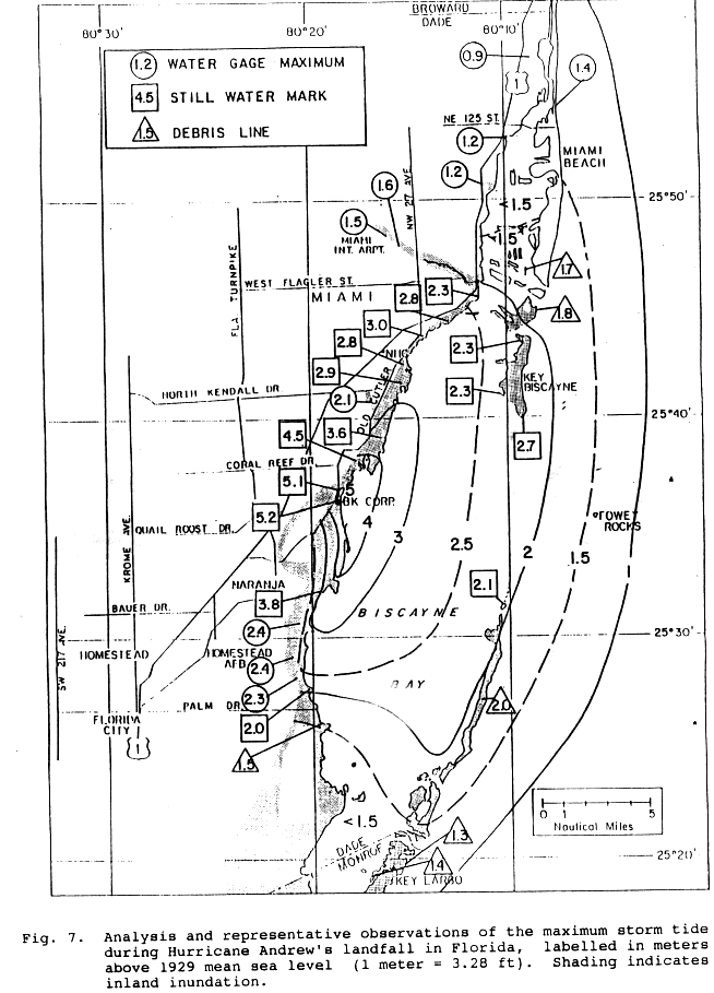
NOAA, 2012o, National Oceanic Atmospheric Administration (NOAA), National Weather Service (NWS),
National Hurricane Center (NHC), "NIC Data Achieve - Best Track Data (HURDAT)," Available at:
http://www.nhc.noaa.gov/pastall.shtml#hurdat, Accessed: 12/14/2012.
NOAA, 2012p, National Oceanic and Atmospheric Administration (NOAA), Hurricane Research Division, Atlantic Oceanographic & Meteorological Laboratory, Wind Field Analysis Data, Website, http://www.aoml.noaa.gov/hrdl/datasub/wind.html, Updated through 2012.
NOAA, 2013a, National Oceanic and Atmospheric Administration (NOAA), Tides and Currents, Virginia Key, FL, NOAA Tides & Currents Website, http://tidesandcurrents.noaa.gov/station-info.shtml?stn=8723214 Virginia Key, FL, accessed February 13, 2013.
NOAA, 2013b, National Oceanic and Atmospheric Administration (NOAA), Tides and Currents, Vaca Key, FL, NOAA Tides & Currents Website, http://tidesandcurrents.noaa.gov/stationinfo.shtml?stn=8723970 Vaca Key, FL, accessed February 13, 2013.
NOAA, 2013c, National Oceanic and Atmospheric Administration (NOAA), Tides and Currents, Key West, FL, NOAA Tides & Currents Website, http://tidesandcurrents.noaa.gov/stationinfo.shtml?stn=8724580 Key West, FL, accessed February 13, 2013.
NOAA, 2013d, National Oceanic Atmospheric Administration (NOAA), Tides and Currents, "Government Cut, Miami Harbor Entrance 8723178 Tidal Data Daily View," Available at:
http://tidesandcurrents.noaa.gov/noaatidepredictions/NOAATidesFacade.jsp?Stationid=8723178, Accessed:
1/4/2013.
NPS, 2013, United States National Park Service (NPS), "Biscayne National Park - Environmental Factors,"
Available at http://www.nps.gov/bisc/naturescience/, Accessed February 13, 2013.
NRC, 1976, U.S. Nuclear Regulatory Commission (NRC), Flood Protection for Nuclear Power Plants, Regulatory Guide 1.102 (NRC RG 1102), Rev. 1, Washington, D.C., 1976.
NRC, 1977, United States Nuclear Regulatory Commission (NRC), "Design Basis Floods for Nuclear Power Plants," Regulatory Guide 1.59, Revision 2 Washington, D.C., 1977.
NRC, 1978, United States Nuclear Regulatory Commission (NRC), "Standard Format and Content of Safety Analysis Reports for Nuclear Power Plants," Regulatory Guide 1.70, Revision 3, Washington, D.C., 1978.
NRC, 2007, United States Nuclear Regulatory Commission (NRC), "Standard Review Plan for the Review of Safety Analysis Reports for Nuclear Power Plants: LWR Edition," NUREG-0800, Washington, D.C.,
March, 2007.
86
NTTF Recommendation 2.1 (Hazard Reevaluations): Flooding EN ERC O N Florida Power & Light Company - PTN March 2013 Excellence-Every project. Every day.
FPL062-PR-001, Rev. 0 NRC, 2009, United States Nuclear Regulatory Commission (NRC), "Tsunami Hazard Assessment at Nuclear Power Plant Sites in the United States of America - Final Report," NUREG/CR-6966, PNNL-17397, Richland, WA, March 2009.
NRC, 2011, United States Nuclear Regulatory Commission (NRC), "Design-Basis Flood Estimation for Site Characterization at Nuclear Power Plants in the United States of America," NUREG/CR-7046, Washington, D.C., November, 2011.
NRC, 2012a, U.S. Nuclear Regulatory Commission, Letter to Licensees, Request for Information Pursuant to Title 10 of the Code of Federal Regulations 50.54(f) Regarding Recommendations 2.1, 2.3, and 9.3 of the Near Term Task Force Review of Insights from the Fukushima Dai-ichi Accident, March 12, 2012.
NRC, 2012b, United States Nuclear Regulatory Commission (NRC), "Turkey Point Units 3 & 4 - Issuance of Amendments Regarding Extended Power Uprate (TAC NOS. ME4907 and ME4908)," MLI 1293A365, Washington, D.C., June 15, 2012.
NRC, 2013, United States Nuclear Regulatory Commission (NRC), "Guidance for Performing a Tsunami, Surge and Seiche Flooding Safety Analysis Revision 0," Japan Lessons-Learned Project Directorate Interim Staff Guidance, JLD-ISG-2012-06, January 4, 2013.
NWS, 1979, National Weather Service (NWS), National Weather Service (NWS) Technical Report (TR) 23, "Meteorological Criteria for Standard Project Hurricane and Probable Maximum Hurricane Windfields, Gulf and East Coast of the United States," United States Department of Commerce, National Oceanic Atmospheric Administration (NOAA), September 1979.
NWS, 1987, National Weather Service (NWS), National Weather Service (NWS) Technical Report (TR) 83, "Hurricane Climatology for the Atlantic and Gulf Coasts of the United States," United States Department of Commerce, National Oceanic Atmospheric Administration (NOAA), April 1987.
Palm Beach County, 2009, "Palm Beach County Unified Local Mitigation Strategy," Palm Beach County Government Website, http://www.pbcgov.com/dem/publications/pdf/2009LMSPlan.pdf, accessed February 2013.
Pararas-Carayannis, G., 2002, "Evaluation of the Threat of Mega Tsunami Generation from Postulated Massive Slope Failures of Island Stratovolcanos on La Palma, Canary Islands, and on the Island of Hawaii,"
Science of Tsunami Hazards, Volume 20, No. 5, pp. 251-277, 2002.
Pasch, 2006a, Pasch, R.J. et al, 2006, National Hurricane Center, "Tropical Cyclone Report Hurricane Wilma 15-25 October 2005," Website, http://www.nhc.noaa.gov/pdf/TCR-AL252005_Wilma.pdf, Updated September 28, 2006.
Pasch, 2006b, Pasch, R.J. et al, 2006, National Hurricane Center, "Preliminary Report Hurricane Floyd 7-17 November 1999," Website, http://www.nhc.noaa.gov/l999floyd.html, November 18, 1999 Peters et al., 2002, Peters, H., Shay, L.K., Mariano, A.J., and Cook, T.M., "Current variability on a narrow shelf with large ambient vorticity," J. Geophys. Res., 107, C8, 3087, August 2002.
87
NTTF Recommendation 2.1 (Hazard Reevaluations): Flooding O
EN ERC O N Florida Power & Light Company - PTN March 2013 Excellence-Every project. Every day.
FPL062-PR-00 1, Rev. 0 Rappaport, 2005, Rappaport, E., 2005, National Hurricane Center, "Preliminary Report Hurricane Andrew 16-28 August 1992," Website, http://www.nhc.noaa.gov/1992andrew.html, Updated 10 December 1993, Addendum 7 February 2005.
Renken et al., 2005, Renken, R.A., J. Dixon, J. Koehmstedt, A.C. Lietz, R. L. Marella, P. Telis, J. Rodgers, and S. Memberg, "Impact of Anthropogenic Development on Coastal Ground-Water Hydrology in Southeastern Florida, 1900-2000," Circular 1275, U.S. Geological Survey, 2005.
Resio and Westerink, 2008, Resio, D.T., and Westerink, J.J., "Modeling the Physics of Storm Surge, Physics Today," Volume 61, Issue 9, pp. 33-38, 2008.
SFDEM, 2009, State of Florida Division of Emergency Management (SFDEM) LiDAR Project Survey, "Miami-Dade County 2ft Contour Lines," Scale 1:24,000, 2009SFDEM Website, http://www.fgdl.org/metadataexplorer.jsp, accessed August 2012.
SFWMD, 2006, South Florida Water Management District (SFWMD), "Preliminary Design Report Cutler Wetlands C-I Flow Way and L-31E Culverts, Biscayne Bay Coastal Wetlands-Phase 1," 2006.
SFWMD, 2007a, South Florida Water Management District (SFWMD), "2007 Miami-Dade 10-ft DEM in NAVD 1988," Release Version 1, SFWMD Website, http://my.sfwmd.gov/gisapps/sfwmdxwebdc/dataview.asp?, accessed August 2012.
SFWMD, 2007b, South Florida Water Management District (SFWMD), "2007-08 Florida Keys 10-ft DEM in NAVD88," Release Version 1, SFWMD Website, http://my.sfwmd.gov/gisapps/sfwmdxwebdc/dataview.asp?, accessed August 2012.
Soloviev, et al., 2003, Soloviev, A.V., Luther, M.E., and Weisberg, R.H., "Energetic baroclinic super-tidal oscillations on the southeast Florida shelf," Geophysical Research Letters, Vol. 30, No. 9, 1463, May 2003.
Stewart, 2005, Stewart, S.R., 2005, National Hurricane Center, "Tropical Cyclone Report Hurricane Ivan 2-24 September 2004," Website, http://www.nhc.noaa.gov/2004ivan.shtml?, Updated May 27, 2005.
Tilmant et al, 1994, Tilmant, J.T., Curry, T.W., Jones, R., Szmant, A., Zieman, J.C. Flora, M., Robblee, M.B., Smith, D., Snow, R.W., and Wanless, H.R., "Hurricane Andrew's Effects on Marine Resources,"
BioScience, Volume 44, no. 4, pp. 230-237, 1994.
USACE, 1984, United States Army Corps of Engineers (USACE), "Shore Protection Manual, Volumes 1 and 2," 1984.
USACE, 2008, U.S. Army Corps of Engineers, Ice Jam Database, Cold Region Research and Engineering Laboratory (CRREL), http://www.crrel.usace. army.mil/ierd/icejam/icejam.htm, accessed August 13, 2008.
USACE, 2011, United States Army Corps of Engineers (USACE), "Coastal Engineering Manual," EM 1110-2-1100, August 2011.
USDC, 1953, United States Department of Commerce (USDC), Coast and Geodetic Survey, "Density of Sea Water at Tide Stations - Atlantic Coast - North and South America," Special Publication No. 279 (Formerly No. DW-1) Revised 1953 Edition, United States Government Printing Office, Washington D.C.,
1953.
88
NTTF Recommendation 2.1 (Hazard Reevaluations): Flooding EN ERC O N Florida Power & Light Company - PTN March 2013 Excellence-Every project Every day.
FPL062-PR-001, Rev. 0 USGS, 1989, U.S. Geological Survey (USGS), Florida Topographic 2-Sided Map, Florida South Section, Scale 1:500,000, Palm Beach County, Florida, Unified Local Mitigation Strategy.
USGS, 1994, U.S. Geological Survey (USGS), Card Sound Quadrangle, Florida-Dade County, 7.5 Minute Series Topographic Map.
USGS, 1997, U.S. Geological Survey (USGS), Arsenicker Keys Quadrangle, Florida-Dade County, 7.5 Minute Series Topographic Map.
USGS, 1998, United States Geological Survey (USGS), "Arsenicker Keys, FL," and "Elliot Key, FL" 7.5-minute Topographic Map, Scale 1:24,000, 1998.
USGS, 2004, United States Geological Survey (USGS), "Novel Geophysical and Geochemical Techniques Used to Study Submarine Groundwater Discharge in Biscayne Bay," Florida, Fact Sheet 2004-3117, September 2004.
USGS, 2008, U.S. Geological Survey (USGS), Water-Quality Samples for the Nation, Water Temperatures for Biscayne Canal at S-28 Near Miami, Florida (Station #02286340), Little River Canal at S-27 at Miami, Florida (Station #02286380), Miami Canal at NW36 ST, Florida (Station #02288600), Miami Canal at Water Plant at Hialeah, Florida (Station #02288500), Miami Canal East of Levee 30 Near Miami, Florida (Station #02287395), Mowry Canal Near Homestead, Florida (Station #02290725), Snake Creek Ca at S-29 at North Miami Beach, Florida (Station #02286300), Snake Creek Canal at NW67 Ave Nr Hialeah, Florida (Station #02286200), Snake Creek Canal Below S-30 Nr Hialeah, Florida (Station #02286181), Tamiami Canal near Coral Gables, Florida (Station #02289500), Tamiami Canal Outlets L-30 to L-67A Nr Miami, Florida (Station #02289060), West Highway Creek near Homestead, Florida (Station #251433080265000),
Snapper Creek C at Miller Drive Nr Miami, Florida (Station #022906 10). USGS website, http://nwis.waterdata.usgs.gov/usa/nwis/qwdata, accessed September 25, 2008.
USGS, 2009, United States Geological Survey (USGS), "1/3-Arc Second National Elevation Dataset (NED)," published 2009, NED bounding coordinates 80.29300 to 80.68200 West to 25.27400 to 25.7890°North, USGS National View Website, http://viewer.nationalmap.gov/viewer, accessed August 2012.
Vatvani et al., 2012, Vatvani, D., N.C. Zweers, M. van Ormondt, A.J. Smale, H. de Vries, and V.K.
Makin, "Storm Surge and Wave Simulations in the Gulf of Mexico Using a Consistent Drag Relation for Atmospheric and Storm Surge Models," Natural Hazards and Earth System Sciences, 12, pp. 2399-2410, doi: 10.5194/nhess-12-2399-2012, 2012.
Vickery et al., 2009, Vickery, Peter J., Forrest J. Masters, Mark D. Powell, Dhiraj Wadhera, "Hurricane Hazard Modeling: The Past, Present, and Future," Journal of Wind Engineering and Industrial Aerodynamics, doi: 10.1016/j.jweia.2009.05.005.
Walton, 2007, Walton, Todd L., "Projected sea level rise in Florida," Ocean Engineering, Volume 34, pp.1832-1840, 2007.
Willoughby et al, 1989, Willoughby, H.E. et al, 1989, "Notes and Correspondence, A record Minimum Sea Level Pressure Observed in Hurricane Gilbert," Monthly Weather Review, Volume 117, pp.28 24-2 825.
Website, http://joumals.ametsoc.org/doi/abs/10.1175/1520-0493%281989%29117%3C2824%3AARMSLP%3E2.0.CO%3B2, February 26, 1989 and June 3, 1989.
89
NTTF Recommendation 2.1 (Hazard Reevaluations): Flooding SEN ERC O N Florida Power & Light Company - PTN March 2013 Excellence-Every project Every day.
FPL062-PR-00 1, Rev. 0 Wingard et al. 2004, Wingard, G.L., T.M. Cronin, C. W. Holmes, D. A. Willard, G. Dwyer, S. E. Ishman, W. Orem, C. P. Williams, J. Albietz, C. E. Bernhardt, C. A. Budet, B. Landacre, T. Lerch, M. Marot, R. E.
Ortiz, "Ecosystem History of Southern and Central Biscayne Bay: Summary Report on Sediment Core Analyses - Year Two," Open File Report 2004-1312, U.S. Geological Survey, October 2004.
Wolfert et al., 2007, Wolfert-Lohmann, M.A., C.D. Langevin, S.A. Jones, C.D. Reich, G.L. Wingard, I.B.
Kuffner, and K.J. Cunningham, "U.S. Geological Survey Science Support Strategy for Biscayne National Park and Surrounding Areas in Southeastern Florida," Open File Report 2007-1288, United States Geological Survey (USGS), 2007.
WL-Delft Hydraulics, 1991, Verboom, G. K., J.G. de Ronde, and R.P. van Dijk, "A Fine Grid Tidal Flow and Storm Surge Model of the North Sea," Publication number 456, WL-Delft Hydraulics, May 1991.
Yang, 2012, Yang, E., E. P. Myers, I. Jeong, and S. A. White, "VDatum for Coastal Waters from the Florida Shelf to the South Atlantic Bight: Tidal Datums, Marine Grids, and Sea Surface Topography," U.S.
Department of Commerce, National Oceanic and Atmospheric Administration, Silver Spring, Maryland, NOAA Technical Memorandum NOS CS 27, 97 pp.
90
O ENERCON Excellen ce-Every project Every day.
NTTF Recommendation 2.1 (Hazard Reevaluations): Flooding Florida Power & Light - PTN March 2013 FPL062-PR-00 1, Rev. 0 Table 2-1. Site Tidal Datum Conversions Datum Input (Conversion From)
Datum Output NAVD88 LMSL NGVD29 MLW MLLW (Conversion To:)NAD8________________
Feet Meters Feet Meters Feet Meters Feet Meters Feet Meters NAVD88 0.000 0.000
-0.868
-0.265
-1.527
-0.465
-1.652
-0.504
-1.761
-0.537 LMSL 0.868 0.265 0.000 0.000
-0.659
-0.201
-0.784
-0.239
-0.892
-0.272 NGVD29 1.527 0.465 0.659 0.201 0.000 0.000
-0.125
-0.038
-0.233
-0.071 MLW 1.652 0.504 0.784 0.239 0.125 0.038 0.000 0.000
-0.109
-0.033 MLLW 1.761 0.537 0.892 0.272 0.233 0.071 0.109 0.033 0.000 0.000 MLW-SiteCa) 2.307 0.703 (a)
The plant site was built using -2.307 MLW, which is used for most surveys and as-built drawings within the plant site. The site bench marks are based on the -2.307 MLW elevations as the reference datum, as was the accepted standard differential between MSL and MLW per detail G 1.1 of the Metropolitan Dade County Public Works Manual in the 1970's (Ford, 2012a).
ENE RCON Excellen ce--Evefy project. Every day.
NTTF Recommendation 2.1 (Hazard Reevaluations): Flooding Florida Power & Light - PTN March 2013 FPL062-PR-001, Rev. 0 Table 2-2. East Miami-Dade County Drainage Subbasin Areas and Outfall Structures Drainage Structure Subbasin Area Outfall Design Headwater Design Name Major Canal Square Structure Structure Type Stage Feet NGVD 29 Cubic Feet Miles per Second C-9(a)
Snake Creek Canal (C-9) 98 S-29 Spillway, 4 gates 3.0 4780 C-8 Biscayne Bay Canal (C-8) 31.5 S-28 Spillway, 2 gates 2.3 3220 C-7 Little River Canal (C-7) 35 S-27 Spillway, 2 gates 3.2 2800 C-6 Miami Canal (C-6) 69 S-26 Spillway, 2 gates 4.4 3400 S-25B Spillway, 2 gates 4.4 2000 C-5 Comfort Canal (C-5) 2.3 S-25 Culvert 2.5 260 C4 Tamiami Canal (C-4)(b) 60.9 S-25A Gated Culvert N/A(c)
N/A C-3 Coral Gables Canal (C-3) 18 G-97 Weir 4.5 640 C-2 Snapper Creek Canal (C-2) 53 S-22 Spillway, 2 gates 3.5 1950 C-100 C-100 Canal 40.6 S-123 Spillway, 2 gates 2.0 2300 C-I Black Creek Canal (C-i) 56.9 S-21 Spillway, 3 gates 1.9 2560 C-102 C-102 Canal 25.4 S-21A Spillway, 2 gates 1.9 1330 C-103 Mowry Canal (C-103) 40.6 S-20F Spillway, 3 gates 1.9 2900 Homestead Military Canal 4.7 S-20G Spillway, 1 gate 2.0 900 North Canal North Canal(d) 7.8 S-20F Spillway, 3 gates 1.9 2900 Florida City Florida City Canal(e) 12.5 Model Land Model Land Canal 28.1 S-20 Spillway, 1 gate 1.5 450 C-111 C-111 Canal 100 S-197 Gated:Culvert 1.4 550 (SFWMD, 2006)
(a)
Subbasin C-9 combines areas C-9 West and C-9 East (b)
Joins with Subbasins C-5 and C-6 and outflows through S-25 and S-25B (c)
N/A indicates data not available (d)
Outflows through S-20F (e)
No outflow structure; joins with L-31E Canal
O ENERCON Excellence-Every project Every day.
NTTF Recommendation 2.1 (Hazard Reevaluations): Flooding Florida Power & Light - PTN March 2013 FPL062-PR-001, Rev. 0 Table 2-3. NOAA Tide Gages Near PTN and Corresponding Tidal Range Great Diurnal Site Number Site Name Latitude Longitude Start Date End Date Tide Range(a)
Feet 8723289 Cutler, Biscayne Bay, FL 250 36.9' 800 18.3' 5/1/1970 3/31/1972 2.13 8723355 Ragged Key No. 5, Biscayne Bay, FL 250 31.4' 800 10.5' 8/1/1987 9/30/1987 1.68 8723393 Elliott Key (Outside). FL 250 28.6' 800 10.8' 7/1/1974 7/31/1974 2.53 8723409 Elliott Key Harbor, Elliott Key, FL 250 27.2' 800 11.8' 7/1/1974 8/31/1987 1.66 8723423 Turkey Point, Biscayne Bay, FL 250 26.2' 800 19.8' 5/1/1970 8/31/1993 1.78 8723465 East Arsenicker, Card Sound, FL 250 22.4' 800 17.4' 12/1/1971 2/29/1972 1.02 8723439 Billys Point, Elliott Key, FL 25° 24.9' 800 12.6' 7/1/1974 7/31/1974 1.64 8723506 Pumpkin Key, Card Sound, FL 250 19.5' 800 17.6' 8/1/1987 9/30/1987 0.75 8723534 Card Sound Bridge, FL 250 17.3' 800 22.2' 5/1/1970 7/31/1971 0.63 8723170 Miami Beach, FL 250 46.1' 800 7.9' 1/30/1985 12/01/1986 2.50 8725110 Naples, FL 260 7.9' 810 48.4' 3/4/1965 12/29/1986 2.87 8723214"1 Virginia Key, FL 250 43.9' 800 9.7' 1/28/1994 12/29/2012 2.19 8723970(')
Vaca Key, FL 240 42.7' 810 6.3' 12/1/1995 12/29/2012 0.97 8724580(b)
Key West, FL 240 33.2' 81 048.5' 11/27/1973 12/29/2012 1.81 (NOAA, 2012a-i)
(a) Great diurnal tide range is the difference between the mean higher high and mean lower low tide levels (b) Active stations
O ENERCON Excellence-Every project. Every day.
NTTF Recommendation 2.1 (Hazard Reevaluations): Flooding Florida Power & Light - PTN March 2013 FPL062-PR-00 1, Rev. 0 Table 3-1. PTN Tornado Generated Missiles Missile Size Velocity (mph)
Weight (Ibs)
Corrugated Sheet of Siding 4 ftx 8 ft 225 100 Bolted Wood Decking 10 ftx 4 fix 4 ft 200 450 Passenger Car (on ground) 50 4000 (FPL, 1991)
OENERCON Excellence-Every project Every day.
NTTF Recommendation 2.1 (Hazard Reevaluations): Flooding Florida Power & Light - PTN March 2013 FPL062-PR-00 1, Rev. 0 Table 3-2. SRP Defined Missiles Missile Spectrum A "No Tumbling" Missile Spectrum Fraction of Total 300 MPH Horizontal Horizontal Missile Mass (lbs)
Dimensions Tornado Velocity Wind Field Velocity (ft/sec)
Velocity (MPH)
Wood Plank 200 4 in. x 12 in. x 12 ft 0.8 240 368 250.9 3" Sch 40 Pipe 78 10 ft long 0.4 120 NA NA 1" Sch 40 Pipe 115 15 ft long NA NA 268 182.7 1" Steel Rod 8
3 ft long 0.6 180 259 176.5 6" Sch 40 Pipe 285 15 ft long 0.4 120 230 156.8 12" Sch 40 Pipe 743 15 ft long 0.4 120 205 139.7 Utility pole 1490 13 1/2 in dia., 35 ft long 0.4 120 241 164.3 Automobile 4000 frontal area 20 ft2 0.2 60 100 68.1 (FPL, 1991) and (NRC, 2007)
0 ENERCON Excellence--Every project. Every day:.
NTTF Recommendation 2.1 (Hazard Reevaluations): Flooding Florida Power & Light - PTN March 2013 FPL062-PR-001, Rev. 0 Table 4-1. 1-Minute Precipitation Depths, 1-Hour LIP Center Temporal Distribution Cumulative Cumulative Incremental Cumulative Fraction of Incremental Cumulative Fraction of Precipitation Precipitation Total Precipitation Precipitation Total Minute (in.)
(in.)
Rainfall Minute (in.)
(in.)
Rainfall 1
0.175 0.175 0.009 31 1.242 8.581 0.442 2
0.175 0.349 0.018 32 1.242 9.823 0.506 3
0.175 0.524 0.027 33 1.242 11.064 0.570 4
0.175 0.698 0.036 34 1.242 12.306 0.634 5
0.175 0.873 0.045 35 1.242 13.548 0.698 6
0.175 1.048 0.054 36 0.349 13.897 0.716 7
0.175 1.222 0.063 37 0.349 14.246 0.734 8
0.175 1.397 0.072 38 0.349 14.595 0.752 9
0.175 1.571 0.081 39 0.349 14.944 0.770 10 0.175 1.746 0.090 40 0.349 15.294 0.788 11 0.175 1.921 0.099 41 0.297 15.591 0.804 12 0.175 2.095 0.108 42 0.297 15.889 0.819 13 0.175 2.270 0.117 43 0.297 16.186 0.834 14 0.175 2.444 0.126 44 0.297 16.484 0.850 15 0.175 2.619 0.135 45 0.297 16.781 0.865 16 0.297 2.916 0.150 46 0.175 16.956 0.874 17 0.297 3.214 0.166 47 0.175 17.130 0.883 18 0.297 3.511 0.181 48 0.175 17.305 0.892 19 0.297 3.809 0.196 49 0.175 17.479 0.901 20 0.297 4.106 0.212 50 0.175 17.654 0.910 21 0.297 4.404 0.227 51 0.175 17.829 0.919 22 0.297 4.701 0.242 52 0.175 18.003 0.928 23 0.297 4.999 0.258 53 0.175 18.178 0.937 24 0.297 5.296 0.273 54 0.175 18.352 0.946 25 0.297 5.594 0.288 55 0.175 18.527 0.955 26 0.297 5.943 0.306 56 0.175 18.702 0.964 27 0.349 6.292 0.324 57 0.175 18.876 0.973 28 0.349 6.641 0.342 58 0.175 19.051 0.982 29 0.349 6.990 0.360 59 0.175 19.225 0.991 30 0.349 7.340 0.378 60 0.175 19.400 1.000
OENERCON Excellence-Every project Every day.
NTTF Recommendation 2.1 (Hazard Reevaluations): Flooding Florida Power & Light - PTN March 2013 FPL062-PR-001, Rev. 0 Table 4-2. Table of Results for Flow Depth, Peak Water Surface Elevation (WSEL), and Maximum Flow Velocity (Scenario A)
WSEL Velocity WSEL Velocity Location Depth (ft)
(NAVD88)
(ft/s)
Location Depth (ft)
(NAVD88)
(ft/s) 1 0.81 15.77 1.44 18 1.19 16.45 2.64 2
1.31 15.78 0.22 19 0.62 16.06 0.23 3
0.98 15.75 0.76 20 0.80 16.14 0.69 4
0.68 15.80 1.42 21 0.66 16.04 0.24 5
0.68 15.81 1.51 22 0.83 16.04 0.14 6
0.60 15.85 0.35 23 0.60 15.93 0.07 7
0.61 17.61 0.18 24 0.61 15.83 0.12 8
0.68 15.66 0.47 25 0.61 18.82 1.61 9
0.61 17.63 0.25 26 0.60 28.12*
0.12 10 0.74 15.58 1.33 27 0.71 15.81 0.58 11 0.64 15.98 2.11 28 0.70 15.80 1.45 12 0.68 16.02 0.57 29 0.65 15.77 0.80 13 1.09 18.82 1.56 30 0.60 4.02 0.05 14 0.60 19.93 0.45 31 0.89 2.77 0.98 15 1.37 16.92 0.95 32 0.72 2.97 0.70 16 1.22 16.86 0.38 33 0.60 14.61 0.00 17 1.20 16.57 1.74
0 ENERCON Excellence-Every project. Every day.
NTTF Recommendation 2.1 (Hazard Reevaluations): Flooding Florida Power & Light - PTN March 2013 FPL062-PR-001, Rev. 0 Table 4-3. Summary of Results for the Analysis of the Flood Protected Areas (Scenario B)
Flood Protected Area Time of Maximum Depth Maximum Depth (ft)
CCW3 57 min 0.88 CCW4 59 mrin 0.97 Unit 3 Condenser Pit 60 min 7.87 Unit 4 Condenser Pit 60 min 7.87
O ENERCON Excellence-Every project Every doy.
NTTF Recommendation 2.1 (Hazard Reevaluations): Flooding Florida Power & Light - PTN March 2013 FPL062-PR-001, Rev. 0 Table 4-4. Topographic and Bathymetric Characteristics of Datasets Used as Input for Hurricane Modeling Area Data Type Source Horizontal Coordinate Vertical/Tidal Vertical Resolution System Datum Units Regional Topography &
GEBCO, 2008 30 arc-second WGS 1984 GCS MSL meters grid Bathymetry
(-1 km)
Site grid Topography USGS, 2009 10 meter NAD 1983 GCS NAVD88 meters Site ~
grd 1-m NED)
Topography SFWMD, 2007a State Plane Site grid (10-ft DEM SFWMD, 2007b 10 foot Florida East, NAVD88 feet LiDAR)
NAD83 State Plane Site grid Topography Ford, 2012b Survey Florida East, NAVD88 feet I_
NAD83 Site grid Bathymetry NOAA, 2008c soundings NAD 1983 GCS MLLW meters (ENC)
Site grid Bathymetry NOAA, 2005 Soundings NAD 1983 GCS MLW feet (NOS)
Soundings NAD_1983 GCS
_MLWfeet
O ENERCON Excellence-Every project Every day.
NTTF Recommendation 2.1 (Hazard Reevaluations): Flooding Florida Power & Light - PTN March 2013 FPL062-PR-001, Rev. 0 Table 4-5. Vertical Unit and Datum Conversions for Datasets within the Site Grid Horizontal Datum Vertical Units Vertical Datum Conversion Conversion Conversion Topography USGS, 2009 NAD83 to WGS84 None - data in NAVD88 to MSL meters SFWMD, 2007a NAD83 to WGS84 Feet to meters NAVD88 to MSL Topography SFWMD, 2007b Topography Ford, 2012b NAD83 to WGS84 Feet to meters NAVD88 to MSL Bathymetry NOAA, 2008c NAD83 to WGS84 None - data in MLLW to MSL (ENC) meters Bathymetry NOAA, 2005 NAD83 to WGS84 None - data in MLW to MSL Bathymetry (NOS) meters
O ENERCON Excellence-Every project Every day.
NTTF Recommendation 2.1 (Hazard Reevaluations): Flooding Florida Power & Light - PTN March 2013 FPL062-PR-001, Rev. 0 Table 4-6. Station Results for 10% Exceedance High and Low Tide Record Record Approximate 10% Exceedance 10% Exceedance Station ID Station Name Years of Data Period Period Distance to High Tide Low Tide Available Available Used Turkey Point High TdLoTide (years)
(years)
(miles)("
1 (feet-NAVD88)
(feet-NAVD88) 1913-1935 &
1941 - 1952 &
8724580 Key West 1954 -2012 94 21 108 1.07
-2.59 8723214 Virginia Key 1994 -2012 19 19 22 1.41
-2.7 1931-1951 &
8723170 Miami Beach 1955 -1981 48 21 26 1.27
-3.63 8723970 Vaca Key 1971 -2012 42 21 70 0.66
-1.98 8725110 Naples 1965 -2012 48 21 103 1.97
-3.71 (NOAA., 2012a-i)
(a) PTN center point location: 25.434488' N, 80.3312450 W
O ENERCON Excellence-Every project Every doy.
NTTF Recommendation 2.1 (Hazard Reevaluations): Flooding Florida Power & Light - PTN March 2013 FPL062-PR-001, Rev. 0 Table 4-7. Tide Station Trend Model Results 20 Year 100 Year Record Approximate 20 Year Non-Linear 100 Year Non-Linear Station ID Station Name Years of Data Period Distance to Linear Trend 2 d Order Linear Trend 2 d Order (years)
Turkey Point Model Trend Model Model Trend Model (miles)
(feet-NAVD88)
(feet-NAVD88)
(feet-NAVD88)
(feet-NAVD88) 8724580 Key West 1913 - 1935 &
94 108 0.15 0.16 0.75 0.80 1941 - 1952 &
1954-2012 8723214 Virginia Key 1994 -2012 19 22 0.20 0.39 1.00 3.78 8723170 Miami Beach 1931 - 1951 &
48 26 0.15
-0.12 0.75
-2.06 1955 - 1981 8723970 Vaca Key 1971-2012 42 70 0.21 0.38 1.05 2.94 8725110 Naples 1965 -2012 48 103 0.15 0.29 0.73 2.26 (NOAA, 2012a-i)
(a) PTN center point location: 25.434488' N, 80.3312450 W
OENERCON Excellence-Every project. Every day:
NTTF Recommendation 2.1 (Hazard Reevaluations): Flooding Florida Power & Light - PTN March 2013 FPL062-PR-001, Rev. 0 Table 4-8. Calibrated Tidal Station Constituents (Sheet 1 of 5)
Tide Stations Constituent Amplitude Phase KI 0.082 213.905304 01 0.062 217.0151978 PI 0.027 213.8946991 QI 0.012 218.4933014 M2 0.246 13.7205 Baracoa S2 0.048 43.4000015 N2 0.061 354.9986877 K2 0.013 43.4107018 NU2 0.012 357.4628906 M4 0.002 343.7409973 M6 0.004 334.9616089 KI 0.008 213.3054047 01 0.012 331.3151855 001 0
0 S2 0.071 48.5999985 M2 0.337 19.5205002 Q1 0.005 322.2933044 N2 0.078 355.5986023 Cat Cay K2 0.017 52.6106987 NU2 0.015 358.5628967 MU2 0.01 0.541 SI 0.003 27.2999992 M4 0.005 221.141098 L2 0.011 52.5424004 2N2 0.01 331.5768127 LABDA2 0.002 33.5780983 S4 0.002 261.1000061 KI 0.08 263.6643066 01 0.118 245.3721008 PI 0.027 263.6357117 QI 0.023 245.2946014 Cayenne M2 0.962 234.3363953 S2 0.195 267.1000061 N2 0.186 234.358902 K2 0.053 267.028595 KI 0.136 24.7464008 01 0.138 19.4582005 PI 0.044 28.6536007 M2 0.076 244.4046021 Coat Zacoalcos QI 0.027 16.6919994 S2 0.021 246.1999969 N2 0.02 229.7384033 MU2 0.002 242.4091949 Jl 0.011 27.3127003 M4 0.002 142.509201
OENERCON Excellence-Every project Every day.
NTTF Recommendation 2.1 (Hazard Reevaluations): Flooding Florida Power & Light - PTN March 2013 FPL062-PR-001, Rev. 0 Table 4-8. Calibrated Tidal Station Constituents (Sheet 2 of 5)
Tide Stations Constituent [ Amplitude Phase KI 0.098 196.0052948 Daytona Beach 01 0.075 201.0151978 P1 0.032 190.9947052 M2 0.584 11.0205002 QI 0.015 197.9933014 ROI 0.003 202.9575958 S2 0.104 32 N2 0.144 349.9986877 K2 0.022 34.0107002 NU2 0.028 351.9628906 MU2 0.018 353.0409851 SI 0.008 160 M6 0.005 367.9616089 JI 0.006 194.0272064 MI 0.005 194.0834961 2Q1 0.002 204.971405 M4 0.007 71.0410004 S6 0.002 210 L2 0.023 31.0424004 2N2 0.019 327.9768066 LABDA2 0.004 20.9780998 001 0.003 191.9954987 S4 0.006 227 M3 0.003 65.9807968 KI 0.098 196.405304 01 0.075 200.9152069 P1 0.032 190.7946014 QI 0.015 197.9933014 M2 0.584 10.9204998 S2 0.104 32.4000015 N2 0.144 349.6986084 K2 0.022 33.9107018 NU2 0.028 352.4628906 MU2 0.018 353.1411133 L2 0.023 31.0424004 T2 0.006 32.3946991 J1 0.006 194.2272034 M 1 0.005 198.5834961 SA 0.104 197.5052948 SSA 0.077 52.4107018 2N2 0.019 328.4768066 LABDA2 0.004 20.8780994 001 0.003 191.8954926 KI 0.069 194.1643066 Ireland Island PI 0.054 194.7720947 S2 0.083 33
O ENERCON Excellence-Every project Every day.
NTTF Recommendation 2.1 (Hazard Reevaluations): Flooding Florida Power & Light - PTN March 2013 FPL062-PR-00 1, Rev. 0 Table 4-8. Calibrated Tidal Station Constituents (Sheet 3 of 5)
Tide Stations Constituent Amplitude Phase PI 0.023 193.8356934 Q1 0.011 194.5946045 N2 0.086 345.7589111 M2 0.379 5.9363999 K2 0.02 35.3286018 NU2 0.016 349.050293 SA 0.101 238.1643066 T2 0.005 31.8356991 ii 0.004 193.3417969 M4 0.002 247.8728027 L2 0.008 21.1138992 SSA 0.034 11.3284998 MS4 0.002 317.9364014 KI 0.041 244.8054047 01 0.033 268.71521 PI 0.012 248.4947052 M2 0.365 20.4204998 QI 0.006 280.5932922 S2 0.073 44.5 N*2 0.084 0.8987 Miami Harbor Entrance K2 0.019 56.4107018 NU2 0.016 3.4628999 MU2 0.011 356.7409973 T2 0.004 44.4947014 L2 0.01 23.2423992 SA 0.088 198.8052979 SSA 0.062 68.710701 2N2 0.011 341.2767944 KI 0.102 188.905304 01 0.076 193.0151978 Pi 0.038 187.3946991 QI 0.018 163.4933014 M2 0.741 357.2204895 001 0.003 184.7955017 S2 0.134 20.7000008 N2 0.172 340.5986023 BK2 0.034 1.6107 NU2 0.038 333.1629028 MU2 0.025 339.8410034 MSF 0.017 266.4794922 ROI 0.003 194.7575989 MK3 0.008 53.6259003 L2 0.019 334.3424072 T2 0.008 20.6947002 2N2 0.021 329.3768005 J1 0.006 186.9272003
O ENERCON Excellence-Every project Every day.
NTTF Recommendation 2.1 (Hazard Reevaluations): Flooding Florida Power & Light - PTN March 2013 FPL062-PR-001, Rev. 0 Table 4-8. Calibrated Tidal Station Constituents (Sheet 4 of 5)
Tide Stations Constituent Amplitude Phase MI 0.009 215.0834961 S1 0.018 157.6000061 MS4 0.012 235.4205017 MM 0.019 212.4219055 MF 0.022 57.9902 2Ql 0.002 197.0713959 SA 0.109 174.6053009 SSA 0.063 60.8106995 LABDA2 0.011 24.0781002 R2 0.009 260.8052979 M3 0.016 76.7807999 KI 0.087 197.3052979 01 0.065 201.3152008 001 0.003 194.3954926 S2 0.064 31.7000008 PI 0.027 199.3946991 M2 0.379 7.7205 Qi 0.012 195.3932953 ROI 0.002 203.357605 N2 0.092 345.6986084 K2 0.02 40.710701 NU2 0.021 343.6629028 MU2 0.009 357.7409973 SI 0.003 249.3000031 Nassau M6 0.002 383.061615 SA 0.095 144.0052948 T2 0.004 31.6947002 JI 0.005 196.3271942 Ml 0.004 179.3834991 LABDA2 0.003 19.6781006 2Ql 0.002 205.3713989 S6 0.001 208.1000061 M4 0.005 14.441 L2 0.014 41.7424011 SSA 0.031 33.0107002 2N2 0.012 322.6767883 R2 0.001 31.7052994 S4 0.001 268.3999939 M3 0.002 26.0807991 KI 0.088 228.1643066 01 0.073 227.0720978 PI 0.029 228.1356964 San Juan M2 0.146 19.2364006 Ql 0.014 226.0946045 S2 0.024 44.2000008 N2 0.039 353.2589111
O ENERCON Excellence-Every project Every day.
NTTF Recommendation 2.1 (Hazard Reevaluations): Flooding Florida Power & Light - PTN March 2013 FPL062-PR-001, Rev. 0 Table 4-8. Calibrated Tidal Station Constituents (Sheet 5 of 5)
Tide Stations Constituent Amplitude Phase K2 0.007 44.2285004 M6 0.002 353.7092896 KI 0.142 20.1464005 01 0.144 13.7581997 P1 0.047 20.1536007 M2 0.017 110.7045975 QI 0.028 10.4919996 S2 0.009 106.5 N2 0.005 155.5384064 M6 0.003 207.9138947 JI 0.011 23.3127003 South Pass cont.
M i 0.01 16.9801998 M4 0.004 263.5093079 KI 0.131 24.4463997 01 0.132 20.9582005 PI 0.042 27.2535992 QI 0.03 0.592 M2 0.071 250.4046021 S2 0.023 257.1000061 N2 0.017 234.3383942 K2 0.006 257.092804 Tampico NU2 0.003 236.4754944 ROI 0.005 19.4291 JI 0.01 26.2126999 M 1 0.009 22.6802006 001 0.006 27.9346008 2QI 0.003 17.4256992 SA 0.119 176.6463928 SSA 0.074 13.8928003 KI 0.1 244.1643066 01 0.08 217.7720947 PI 0.03 243.8356934 Toco M2 0.27 208.9364014 S2 0.09 242 N2 0.03 176.7588959 K2 0.02 242.328598
NTTF Recommendation 2.1 (Hazard Reevaluations): Flooding dim EFlorida Power & Light - PTN 0 EN E RCe N
March 2013 Excellence-Every project Every doay FPL062-PR-001, Rev. 0 Table 4-12. Range of Storm Parameters for PMSS Parameter Value Overall Storm Diameter 600 nautical miles Storm Peripheral Pressure 30.12 inches of Mercury [Hg]
(1020 mbars)
Storm Central Pressure 26.1 (inches of Mercury [Hg])
(884 mbars)
Storm Radius of Maximum Winds Vary from 4 to 20 nautical miles (NWS23 Prescribed Range)
Storm Forward Speed Vary from 6 to 20 knots Storm Track Direction (degrees clockwise from North)70-190 degrees
O ENERCON Excellence-Every project Every day.
NTTF Recommendation 2.1 (Hazard Reevaluations): Flooding Florida Power & Light - PTN March 2013 FPL062-PR-001, Rev. 0 Table 4-13. The Saffir-Simpson Hurricane Scale Type and Category Wind Speed km/hr (mph, kt)
Approximate Central Pressure kPa (mb, in. Hg)
Tropical Depression (TD)
< 62 (<39, <34)
Tropical Storm (TS)63-117 (39-73, 34-63)
Category 1 (HI) 118-153 (74-95,64-82)
> 98 (>980, >28.94)
Category 2 (H2) 154-177 (96-110, 83-95) 96.5-98 (965-980, 28.50-28.94)
Category 3 (H3) 178-209(111-130,96-113) 94.5-96.5 (945-965, 27.91-28.50)
Category 4 (H4) 210-249(131-155,114-135) 92-94.5 (920-945, 27.17-27.91)
Category 5 (H5)
>250 (>155, >135)
<92 (<920, <27.17)
(Blake et al, 2007)
O ENERCON Excellence-Every project.Evety day.
NTTF Recommendation 2.1 (Hazard Reevaluations): Flooding Florida Power & Light - PTN March 2013 FPL062-PR-001, Rev. 0 Table 4-14. Category 4 & 5 Hurricanes within 100 Nautical Miles of PTN Hurricane Date Category Andrew August 16, 1992 to August 28, 1992 5
Donna August 29, 1960 to September 14, 1960 5
Not Named 1949 August 23, 1949 to August 31, 1949 4
Not Named 1948 October 3, 1948 to October 16, 1948 4
Not Named 1947 September 4, 1947 to September 21, 1947 5
Not Named 1945 September 12, 1945 to September 20, 1945 4
Not Named 1935 August 29, 1935 to September 10, 1935 5
Not Named 1933 August 31, 1933 to September 7. 1933 4
Not Named 1933 October 1, 1933 to October 9. 1933 4
Not Named 1929 September 22, 1929 to October 4, 1929 4
Not Named 1928 September 6, 1928 to September 20, 1928 5
Not Named 1926 September 11. 1926 to September 22, 1926 4
Not Named 1919 September 2. 1919 to September 16, 1919 4
(NOAA, 2012k)
O ENERCON Excellence-Every project. Every day.
NTTF Recommendation 2.1 (Hazard Reevaluations): Flooding Florida Power & Light - PTN March 2013 FPL062-PR-001, Rev. 0 Table 4-15. Central Pressure (Po) and Radius of Maximum Winds (R) for Extreme Hurricanes Radius of Central Pressure Maximum Winds Storm Name Year (millibar)
(nautical miles)
References Gilbert 1988 888 4.3 Willoughby et al, 1989 NOAA, 2012p Andrew 1992 922 10 Raa, 2005 Rappaport, 2005 Opal 1995 916 5
Mayfield, 1995 Mitch 1998 905 14 Guiney and Lawrence. 2000 NOAA, 2012p 921 1.8 Pasch, 2006b Floyd 1999 929 38 NOAA, 2012p 932 43 920 23 Beven and Cobb, 2004 Isabel 2003 930 40 NOAA., 2012p Stewart, 2005 Ivan 2004 910 15 NOAA, 2004 902 18 Knabb,2006a Katrina 2005 917 31 NOAA, 2012p 923 36 897 10 Knabb,2006b Rita 2005 919 18 NOAA, 2012p 924 23 882 1
Pasch, 2006a 892 5
NOAA, 2012p Wilma 2005 910 21 930 17 907 10 Franklin,2008 Dean 2007 918 5
NOAA, 2012p 923 18
O ENERCON Excellence-Every project Every day.
NTTF Recommendation 2.1 (Hazard Reevaluations): Flooding Florida Power & Light - PTN March 2013 FPL062-PR-001, Rev. 0 Table 4-17. USGS Stations Used to Characterize the Typical Water Temperatures Near PTN USGS Station(a)
Station No.
Period of Record BISCAYNE CANAL AT S-28 NEAR MIAMI 2286340 1968-1996 LITTLE RIVER CANAL AT S-27 AT MIAMI 2286380 1958-1996 MIAMI CANAL AT NW36 ST 2288600 1967-1996 MIAMI CANAL AT WATER PLANT AT HIALEAH 2288500 1953-1979 MIAMI CANAL EAST OF LEVEE 30 NEAR MIAMI 2287395 1961-1980 MOWRY CANAL NEAR HOMESTEAD 2290725 1969-1980 SNAKE CREEK CA AT S-29 AT NORTH MIAMI BEACH 2286300 1967-1980 SNAKE CREEK CANAL AT NW67 AVE NR HIALEAH 2286200 1960-1980 SNAKE CREEK CANAL BELOW S-30 NR HIALEAH 2286181 1961-1975 TAMIAMI CANAL NEAR CORAL GABLES 2289500 1963-1980 TAMIAMI CANAL OUTLETS L-30 TO L-67A NR MIAMI 2289060 1953-1982 WEST HIGHWAY CREEK NEAR HOMESTEAD 251433080265000 2003-2007 SNAPPER CREEK C AT MILLER DRIVE NR SMIAMI 2290610 1958-1976 (USGS, 2008)
(a) Water temperature data from 449 stations were examined. Only 13 stations listed in the table above have periodic measurements useful for analysis. In addition, although the period of records for the stations is from 1939 to 2007, data prior to 1953 are sporadic and were not considered in this evaluation.
O ENERCON Excellence-Every project. Every day.
NTTF Recommendation 2.1 (Hazard Reevaluations): Flooding Florida Power & Light - PTN March 2013 FPL062-PR-001, Rev. 0 Table 4-18. Subfreezing and Corresponding Daily Average Temperatures at NCDC Stations Near PTN (Sheet 1 of 2)
Homestead Experimental Station (Period of Record 1910 to 1988)
Temperature 0F Temperature OF Date Minimum Average Date Minimum Average 12/03/1910 31.0 46.5 01/26/1951 30.0 48.0 02/03/1917 30.0 40.0 01/05/1953 32.0 53.5 02/06/1917 32.0 49.5 12/17/1953 32.0 49.0 01/02/1918 30.0 51.0 12/22/1954 30.0 49.0 01/04/1918 27.0 43.5 12/23/1954 32.0 53.5 03/02/1920 31.0 51.5 01/06/1956 31.0 51.5 12/17/1920 32.0 51.0 01/09/1956 29.0 46.5 02/28/1922 29.0 (a) 01/10/1956 31.0 50.5 12/28/1923 27.0 56.5 01/15/1956 27.0 49.0 01/02/1927 30.0 47.5 01/10/1958 31.0 44.5 01/12/1927 30.0 49.0 02/05/1958 27.0 48.5 03/04/1927 32.0 51.0 02/14/1958 32.0 49.0 01/29/1928 30.0 48.5 01/22/1960 29.0 44.0 12/29/1928 32.0 52.0 01/23/1960 30.0 44.5 03/05/1930 32.0 51.0 01/24/1960 28.0 45.5 12/12/1934 31.0 44.5 01/21/1961 32.0 49.5 12/13/1934 26.0 40.0 12/29/1961 32.0 47.0 12/12/1937 32.0 47.5 12/30/1961 32.0 47.5 01/28/1938 32.0 48.5 12/10/1962 30.0 44.0 01/20/1939 32.0 46.5 12/11/1962 29.0 48.0 01/28/1940 28.0 39.5 12/14/1962 30.0 44.5 01/29/1940 30.0 44.0 12/15/1962 31.0 48.5 01/30/1940 30.0 46.0 01/14/1964 32.0 41.5 01/11/1941 31.0 49.0 01/15/1964 30.0 46.5 03/02/1941 26.0 46.0 01/18/1965 30.0 45.0 02/03/1942 30.0 49.0 01/31/1966 31.0 48.0 03/04/1942 32.0 50.5 01/20/1971 30.0 41.5 02/16/1943 26.0 47.0 01/19/1977 31.0 39.5 12/20/1943 30.0 49.0 01/20/1977 27.0 44.0 02/09/1945 32.0 55.0 01/13/1981 31.0 46.0 02/06/1947 29.0 48.5 01/19/1981 32.0 50.0 01/02/1949 30.0 51.5 12/26/1983 31.0 39.5 11/27/1949 31.0 53.0 01/22/1985 30.0 41.0 11/29/1950 30.0 49.0 01/23/1985 32.0 43.0 12/19/1950 30.0 47.0 03/02/1986 32.0 48.0
OENERCON Excellence-Every project Every doy.
NTTF Recommendation 2.1 (Hazard Reevaluations): Flooding Florida Power & Light - PTN March 2013 FPL062-PR-001, Rev. 0 Table 4-18. Subfreezing and Corresponding Daily Average Temperatures at NCDC Stations Near PTN (Sheet 2 of 2)
Homestead Experimental Station (Period of Record 1910 to 1988)
Temperature *F Temperature 'F Date Minimum Average Date Minimum Average 12/20/1950 32.0 49.5 I
Miami International Airport (Period of Record 1948 to 2008)
Temperature 0F Temperature "F Date
-MnmmDate Minimum Average Minimum Average 01/20/1977 31.0 45.0 01/22/1985 30.0 41.5 03/03/1980 32.0 42.5 12/24/1989 31.0 38.0 01/13/1981 32.0 46.5 12/25/1989 30.0 42.5 (NOAA, 2008a)
(a)
This data point is not available. However, based on all the data available, the daily average temperature is not expected to fall below freezing.
D.f 1.0.1 1 0-1-
ý 1-1 erences:
- a..
Overview Map I~*ey FLO A
Clearwar Palm say Potensbug amp F
West Palm B F~wtLaudi P-rN lamril Legend Turkey Point Nuclear Generating Station Units 3&4 (PTN)
Contours - 2 ft interval Feet 0
500 1,000 1,500 I
__ I I
I 0
100 200 300 400 500 Meters Document Name: FPLTP077-GIS-A004 Projection: State Plane Florida East, NAD 83 (US Feet)
Vertical Datum: NAVD88 By: MLS Date: 01/6/2013 Turkey Po Figure 2-1 PTN Site Location Flooding Hazard Reevaluation int Nuclear Generating Station Units 3&4 (PTN)
MHHW - Mean High High Water -The average of the higher high water height of each tidal day.
MHW - Mean High Water - The average of all the high water heights observed.
MSL - Mean Sea Level - The arithmetic mean of hourly heights observed.
MLW - Mean Low Water -The average of all the low water heights observed.
MLLW - Mean Low Low Water - The average of the lower low water height of each tidal day observed.
NAVD88 - North American Vertical Datum 1988 - is a fixed vertical control datum, referenced to the tide station and benchmark at Father Point/Rimouski, Canada was held fixed as the single initial constraint.
NGVD29 - National Geodetic Vertical Datum of 1929 - fixed vertical control datum, affixed to 21 tide stations in the United States and 5 in Canada.
Figure 2-2 Schematic Illustrating Relationships between Fixed and Tidal Datums
Reference:
NOAA, 2011c.
Document Name: FPLO62-GIS-AD14 Flooding Hazard Reevaluation By: MLS Date: 2/8/2013 Turkey Point Nuclear Generating Station Units 3&4 (PTN)
87*
Wb
&51 87=
gr 310 D 3 ALABAMA
_G E, EXPLANATION C:
HYDROLOGIC UNIT CODE 29-(The state of Florida is in region 03) c.
14 SUBnREGIONUME SUBREGIO BUNCN)n 0
SACCOUNTING UNIT NUMBER ACCOJNn]NO UNIT BOUNDARY1 08 r
ATALOGINATUNIT NUBEUNIT B~iJNeRO' CATALOGING UNIT NUMBER CATALOGING UNIT-ACATALOGNG UNIT BNS ACCOUNTNG UNIT AIN ACCOUNTING UNIT 280 BASIN SUB3REGION BASIN SUBREGICN
-W St. Marys River 070204 Waccanasma River 110101 Nassau River 070205 Econfin-Steinhatchea Rivers 110102 Upper St Johns River 080101 Aualla River 110103 Oklawaha River 080102 Upper.*jwianee River 110201 0
Lower St Johns River 080103 Alapaýa River 110202
\\
Daytona-St Auustine Coastal 080201 Withlccoochee River 110203 27-Cape Canaveral Coastal 080202 Lower Suwawnee River 110205 1"
Vero Beach Coastal 080203 Sauta Fe River 110206 1
Kissimmee River 090101 Apalachee Bay-St Marks River 120001 Northmen Okeechobee Inflow 090102 Lower Ochlockc'iee River 120003 Western Okeechobee Inflow 090103 Lower Chattahonchee River 130034 Lake Okeechobee 090201 Ap*aachicola River 130011 Evergiades 090202 Chipbe River 130012 Floida Bay 090203 New River 130013
- 1.
U 2W0 Big Cypress Swainp 090204 Apalahtucosi Say 130014 Caloosathachee Rivser 090205 S1. Andrews-St. Joseph Bays 140101 0%
Peace River 100101 Choctawhatchee Bay 140102 Myakka River 100102 Yellow River 140103 Charlotte Harbor 100103 Blackwater River 140104 Sarasota Bay 100201 Pensacola Bay 140105 O
PTN Manatee River 100202 Perido River 140106 Litle Manatee River 100203 Percldo Bay 140107 25-Alafia River 100204 Pea River 140202 Hillsborough River 100205 Lower Choctawhatchee River 140203 Tampa Bay 100200 Lower Conecuh River 140304 0
25 50 75 100 MILES Crystal-Pithlachascottee Rivers 100207 Escamba River 140305 i
I,.
I I
I I
Withlacoo~hee River 100208 0
25 50 75 100 KILOMETERS I
I IIIIII
Reference:
Marella, 1999.
Legend:
Turkey Point Nuclear Generating Station Units 3&4 (PTN)
Figure 2-4 Map of South Florida Watershed Subregions Document Name: FPL062-GIS-AO15 Flooding Hazard Reevaluation By: MLS Date: 2/8/2013 T-1r.-i Innf l*D=d *ir f
I n
- n Qf[fi*,n I In+
L "NtA ID. ktM y
to
A (1970)
B (1990) 0 10 20 MILES 0
10 20 KILOMETERS Legend Turkey Point Nuclear Generating Station Units 3&4 (PTN)
Reference:
Cooper and Lane, 1987.
Document Name: FPL062-GIS-A014 By: MLS Date: 2/8/2013 Figure 2-5 Surface Water Conveyances System in the South Florida Region in (A) 1970 and (B) 1990 Flooding Hazard Reevaluation Turkey Point Nuclear Generating Station Units 3&4 (PTN)
260W 2504Y 2S5OW 25015'
Reference:
Langevin, 2001.
Legend:
Turkey Point Nuclear Generating Station Units 3&4 (PTN)
Figure 2-6 Locations of Eastern Miami-Dade County Surface Water Management Basins Flooding Hazard Reevaluation Turkey Point Nuclear Generating Station Units 3&4 (PTN)
Document Name: FPL062-GIS-AO15 By: MLS Date: 2/8/2013
269O' 25*45' 25W3 2159Y Legend:
Reference:
Lietz, 1999.
Figure 2-7 Turkey Point Nuclear Generating Station Units 3&4 (PTN)
Document Name: FPL062-GIS-AO15 By: MLS Date: 2/8/2013 Locations of ENP-SDCS Canals, Flow Control Structures on Canal Outlets, and Biscayne Bay Planning Regions Flooding Hazard Reevaluation Turkey Point Nuclear Generating Station Units 3&4 (PTN)
Legend Turkey Point Nuclear Generating Station Units 3 & 4 (PTN)
_ NOAA Tide Stations USGS Stream Gage Stations Airport Military Installation Stream Canal Limited
-Highway Major Railroad Line 0
References:
Miles 0
3
.6 9
I I
I I
I I
I I
I 0
3 6
9 12 KilometX 7S Document Name: FPTP077-GlS-A003 Projection: State Plane Florida East, NAD 83 (US Feet)
By: MLS Date: 01/06/2013 Figurb 2-8 Locations of NOAA Tide and USGS Streamflow Gages Near PTN Flooding Hazard Reevaluation Turkey Point Nuclear Generating Station Units 3&4 (PTN)
350 EXTREME 12" PIPE MEAN 12" PIPE EXTREME 1" ROD EXTREME UTILITY POLE Z=150 Z=150 Z=150 Z=150 EXTREME VEHICLE EXTREME PLANK 90% QUANTILE PLANK EXTREME 12" PIPE Z=10 Z=150 Z=150 Z=33 30
.=.........
250
' 200
- _ 150 Z
0 0
50 100 150 200 250 300 350 SIMULATED WIND SPEED MPH Figure 3-2
Reference:
FPL, 1991.
Missiles Generated by Wind Simulated for Tormis Code Document Name: FPLO62-GIS-A015 Flooding Hazard Reevaluation By: MLS Date: 2/8/2013 Turkey Point Nuclear Generating Station Units 3&4 (PTN)